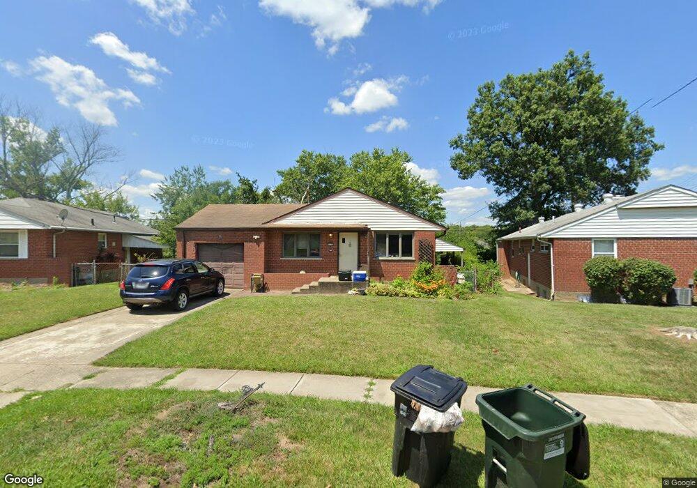
8573 Brent Dr Cincinnati, OH 45231
Finneytown NeighborhoodEstimated Value: $219,000 - $256,000
3
Beds
2
Baths
1,215
Sq Ft
$193/Sq Ft
Est. Value
About This Home
This home is located at 8573 Brent Dr, Cincinnati, OH 45231 and is currently estimated at $234,126, approximately $192 per square foot. 8573 Brent Dr is a home located in Hamilton County with nearby schools including Finneytown Elementary School, Finneytown Secondary Campus, and St. Vivian School.
Ownership History
Date
Name
Owned For
Owner Type
Purchase Details
Closed on
Jan 3, 2018
Sold by
Mead Ian D and Mead Frances A
Bought by
Stuhlreyer Steve J and Stuhlreyer Jennifer J
Current Estimated Value
Home Financials for this Owner
Home Financials are based on the most recent Mortgage that was taken out on this home.
Original Mortgage
$96,224
Outstanding Balance
$82,568
Interest Rate
4.62%
Mortgage Type
FHA
Estimated Equity
$151,558
Purchase Details
Closed on
Aug 31, 2005
Sold by
Gruenwald Peter J and Gruenwald Gael M
Bought by
Mead Ian D
Create a Home Valuation Report for This Property
The Home Valuation Report is an in-depth analysis detailing your home's value as well as a comparison with similar homes in the area
Home Values in the Area
Average Home Value in this Area
Purchase History
| Date | Buyer | Sale Price | Title Company |
|---|---|---|---|
| Stuhlreyer Steve J | $98,000 | None Available | |
| Mead Ian D | $135,000 | None Available |
Source: Public Records
Mortgage History
| Date | Status | Borrower | Loan Amount |
|---|---|---|---|
| Open | Stuhlreyer Steve J | $96,224 |
Source: Public Records
Tax History Compared to Growth
Tax History
| Year | Tax Paid | Tax Assessment Tax Assessment Total Assessment is a certain percentage of the fair market value that is determined by local assessors to be the total taxable value of land and additions on the property. | Land | Improvement |
|---|---|---|---|---|
| 2024 | $3,837 | $53,274 | $10,906 | $42,368 |
| 2023 | $3,709 | $53,274 | $10,906 | $42,368 |
| 2022 | $3,286 | $34,301 | $10,294 | $24,007 |
| 2021 | $3,292 | $34,301 | $10,294 | $24,007 |
| 2020 | $3,260 | $34,301 | $10,294 | $24,007 |
| 2019 | $3,158 | $30,450 | $8,722 | $21,728 |
| 2018 | $2,922 | $30,450 | $8,722 | $21,728 |
| 2017 | $2,828 | $30,450 | $8,722 | $21,728 |
| 2016 | $2,763 | $28,879 | $7,938 | $20,941 |
| 2015 | $2,736 | $28,879 | $7,938 | $20,941 |
| 2014 | $2,733 | $28,879 | $7,938 | $20,941 |
| 2013 | $2,904 | $31,735 | $8,722 | $23,013 |
Source: Public Records
Map
Nearby Homes
- 954 Hollytree Dr
- 958 Hollytree Dr
- 8405 Arundel Ct
- 1013 Vacationland Dr
- 8433 Jonfred Ct
- 1029 Bluejay Dr
- 654 Doepke Ln
- 8622 Mockingbird Ln
- 8627 Mockingbird Ln
- 8816 Falmouth Dr
- 9132 Millcliff Dr
- 1033 Hearthstone Dr
- 8932 Hollyhock Dr
- 984 W Galbraith Rd
- 1100 Gracewind Ct
- 961 W Galbraith Rd
- 831 Compton Rd
- 8608 Long Ln
- 1151 Hempstead Dr
- 9197 Long Ln
- 8567 Brent Dr
- 871 Reynard Ave
- 779 Reynard Ave Unit 8622A
- 8559 Brent Dr
- 861 Reynard Ave
- 870 Reynard Ave
- 8551 Brent Dr
- 8564 Brent Dr
- 8605 Brent Dr
- 8556 Brent Dr
- 8547 Brent Dr
- 860 Reynard Ave
- 880 Reynard Ave Unit 1
- 880 Reynard Ave
- 8620 Winton Rd
- 853 Reynard Ave
- 8613 Brent Dr
- 8548 Brent Dr
- 8630 Winton Rd
- 8610 Brent Dr