8600 Combs Rd Indianapolis, IN 46237
South Franklin NeighborhoodEstimated payment $18,508/month
About This Lot
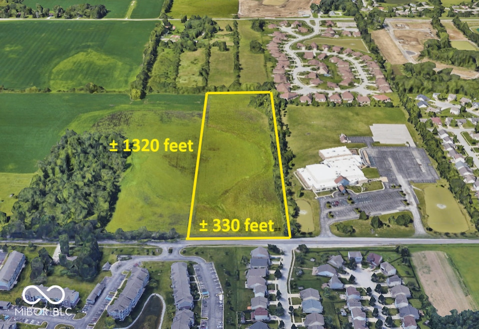
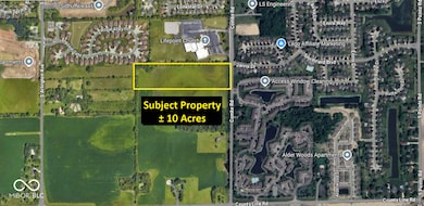
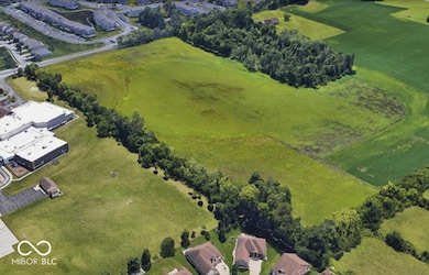
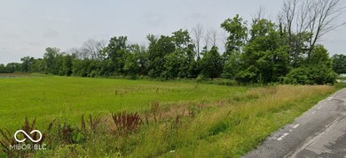
Nestled in the heart of one of Indianapolis's most dynamic and rapidly growing suburban corridors, this exceptional 10-acre parcel offers a rare opportunity for developers, investors, or institutional users seeking visibility, access, and long-term upside. Boasting approximately 330 feet of frontage along Combs Road, the site provides both prominence and flexibility for a wide range of development uses, from residential infill to commercial, mixed-use, or community-oriented projects (subject to zoning). Strategically positioned between South Arlington Avenue and the increasingly active 5 Points Road corridor, with convenient access to County Line Road, the property is directly adjacent to existing residential neighborhoods, community centers, and key service anchors, including Lifepoint Church and numerous retail and multifamily developments. The surrounding area has experienced sustained growth over the past decade, supported by strong demographics, ongoing infrastructure investments, and the expanding footprint of southeastern Marion County's suburban development. With a depth of approximately 1,320 feet, the lot's rectangular configuration and gentle topography make it ideal for efficient site planning and phased development. Whether you're looking to capitalize on the area's residential demand, introduce a new community serving commercial node, or secure long-term land holdings in a prime location, this property offers both immediate appeal and future potential.
Property Details
Property Type
- Land
Est. Annual Taxes
- $296
Lot Details
- 10 Acre Lot
Schools
- Franklin Central Junior High
Community Details
- No Home Owners Association
- Franklin Subdivision
Listing and Financial Details
- Tax Lot 49-15-23-123-002.000-300
- Assessor Parcel Number 491523123002000300
Map
Home Values in the Area
Average Home Value in this Area
Tax History
| Year | Tax Paid | Tax Assessment Tax Assessment Total Assessment is a certain percentage of the fair market value that is determined by local assessors to be the total taxable value of land and additions on the property. | Land | Improvement |
|---|---|---|---|---|
| 2024 | $374 | $22,400 | $22,400 | -- |
| 2023 | $374 | $18,700 | $18,700 | $0 |
| 2022 | $296 | $18,700 | $18,700 | $0 |
| 2021 | $254 | $12,700 | $12,700 | $0 |
| 2020 | $252 | $12,600 | $12,600 | $0 |
| 2019 | $306 | $15,300 | $15,300 | $0 |
| 2018 | $316 | $15,800 | $15,800 | $0 |
| 2017 | $364 | $18,200 | $18,200 | $0 |
| 2016 | $386 | $19,300 | $19,300 | $0 |
| 2014 | $404 | $20,200 | $20,200 | $0 |
| 2013 | $320 | $17,300 | $17,300 | $0 |
Property History
| Date | Event | Price | List to Sale | Price per Sq Ft | Prior Sale |
|---|---|---|---|---|---|
| 08/22/2025 08/22/25 | Price Changed | $3,500,000 | -22.2% | -- | |
| 05/11/2025 05/11/25 | For Sale | $4,500,000 | +1100.0% | -- | |
| 09/04/2020 09/04/20 | Sold | $375,000 | -18.5% | -- | View Prior Sale |
| 09/04/2020 09/04/20 | Pending | -- | -- | -- | |
| 07/27/2020 07/27/20 | Price Changed | $460,000 | -16.3% | -- | |
| 07/15/2020 07/15/20 | For Sale | $549,900 | -- | -- |
Purchase History
| Date | Type | Sale Price | Title Company |
|---|---|---|---|
| Special Warranty Deed | -- | None Listed On Document | |
| Warranty Deed | -- | Mvp National Title | |
| Warranty Deed | $375,000 | Mvp National Title | |
| Interfamily Deed Transfer | -- | -- |
Source: MIBOR Broker Listing Cooperative®
MLS Number: 22038284
APN: 49-15-23-123-002.000-300
Disclaimer: Certain information contained herein is derived from information provided by parties other than Homes.com. All information provided is deemed reliable, but is not guaranteed to be accurate and should be independently verified.
![]() Based on information submitted to the MLS GRID. All data is obtained from various sources and may not have been verified by broker or MLS GRID. Supplied Open House Information is subject to change without notice. All information should be independently reviewed and verified for accuracy. Properties may or may not be listed by the office/agent presenting the information. Some IDX listings have been excluded from this website.
Based on information submitted to the MLS GRID. All data is obtained from various sources and may not have been verified by broker or MLS GRID. Supplied Open House Information is subject to change without notice. All information should be independently reviewed and verified for accuracy. Properties may or may not be listed by the office/agent presenting the information. Some IDX listings have been excluded from this website.
- 7843 Almond Dr
- 6315 Jakes Place
- 6527 Southern Ridge Dr
- 7715 Combs Rd
- 7841 Rosebush Dr
- 6633 Muirfield Way
- 8136 Amble Way
- 6552 Locust Grove Dr
- 7724 Gordon Way
- 7640 Gordon Way
- 8135 Borland Dr
- 6703 Locust Grove Dr
- 8251 Garden Ridge Rd
- 8223 Morera Ct
- 8241 Morera Ct
- 7607 Ardwell Ct
- 8437 Crosser Dr
- 8434 Smithfield Ln
- 8418 Flick Way
- 5914 Edelle Dr
- 8043 Southern Trails Place
- 8144 Amarillo Dr
- 8105 Milender Blvd
- 7516 Inverness Dr
- 7703 Janel Ct
- 6233 Carrie Cir
- 6834 Turnberry Way
- 7150 Combs Rd
- 7925 Carlington Rd
- 5945 Arlo Dr
- 8401 Boggs Creek Dr
- 8940 Latitudes Dr
- 2755 Red Bloom Dr
- 7251 Windsor Lakes Dr
- 5220 Tamarisk Ct
- 7306 Oxbridge Place
- 6737 Amber Springs Way
- 8035 Preidt Place
- 6810 Valley Ridge Dr
- 6241 Amber Valley Ln
