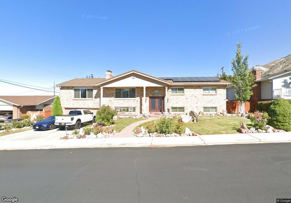
861 E 2620 N Provo, UT 84604
Rock Canyon NeighborhoodEstimated Value: $693,000 - $755,000
6
Beds
3
Baths
3,889
Sq Ft
$186/Sq Ft
Est. Value
About This Home
This home is located at 861 E 2620 N, Provo, UT 84604 and is currently estimated at $723,072, approximately $185 per square foot. 861 E 2620 N is a home located in Utah County with nearby schools including Rock Canyon Elementary School, Centennial Middle School, and Timpview High School.
Ownership History
Date
Name
Owned For
Owner Type
Purchase Details
Closed on
Nov 23, 2009
Sold by
Nelson Michael E and Nelson Veloy S
Bought by
Nelson Michael E and Nelson Veloy
Current Estimated Value
Home Financials for this Owner
Home Financials are based on the most recent Mortgage that was taken out on this home.
Original Mortgage
$210,000
Interest Rate
4.88%
Mortgage Type
New Conventional
Purchase Details
Closed on
May 29, 1997
Sold by
Taylor Dan N and Taylor Madge
Bought by
Nelson Michael E and Nelson Veloy S
Home Financials for this Owner
Home Financials are based on the most recent Mortgage that was taken out on this home.
Original Mortgage
$195,750
Interest Rate
8.08%
Create a Home Valuation Report for This Property
The Home Valuation Report is an in-depth analysis detailing your home's value as well as a comparison with similar homes in the area
Home Values in the Area
Average Home Value in this Area
Purchase History
| Date | Buyer | Sale Price | Title Company |
|---|---|---|---|
| Nelson Michael E | -- | Wasatch Title Insurance Age | |
| Nelson Michael E | -- | -- |
Source: Public Records
Mortgage History
| Date | Status | Borrower | Loan Amount |
|---|---|---|---|
| Closed | Nelson Michael E | $210,000 | |
| Closed | Nelson Michael E | $195,750 |
Source: Public Records
Tax History
| Year | Tax Paid | Tax Assessment Tax Assessment Total Assessment is a certain percentage of the fair market value that is determined by local assessors to be the total taxable value of land and additions on the property. | Land | Improvement |
|---|---|---|---|---|
| 2025 | $463 | $342,430 | -- | -- |
| 2024 | $463 | $340,615 | $0 | $0 |
| 2023 | $449 | $323,950 | $0 | $0 |
| 2022 | $3,211 | $314,160 | $0 | $0 |
| 2021 | $2,571 | $438,700 | $182,700 | $256,000 |
| 2020 | $2,562 | $409,900 | $158,900 | $251,000 |
| 2019 | $2,464 | $409,900 | $158,900 | $251,000 |
| 2018 | $2,149 | $362,700 | $144,400 | $218,300 |
| 2017 | $2,087 | $193,545 | $0 | $0 |
| 2016 | $1,961 | $169,455 | $0 | $0 |
| 2015 | $1,882 | $164,395 | $0 | $0 |
| 2014 | $1,768 | $160,985 | $0 | $0 |
Source: Public Records
Map
Nearby Homes
- 788 E 2680 N
- 1108 E 2620 N
- 758 E 3030 N
- 3129 Cherokee Ln
- 2774 N 370 E
- 2254 N 390 E
- 2848 Foothill Dr
- 3250 Mohawk Ln
- 3025 N 250 E
- 240 E 2230 N Unit 7
- 2735 N Country Club Dr
- 5600 N Canyon Rd
- 186 E 2100 N
- 1801 N 650 E
- 182 E 2090 N
- 3013 N 100 W
- 3057 N 100 W
- 1960 N Canyon Rd
- 2939 N Marrcrest Dr W
- 2999 N Marrcrest West Dr
Your Personal Tour Guide
Ask me questions while you tour the home.