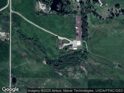
863 Middle Burnt Fork Rd Stevensville, MT 59870
Estimated Value: $297,000 - $1,757,653
4
Beds
3
Baths
3,045
Sq Ft
$324/Sq Ft
Est. Value
About This Home
This home is located at 863 Middle Burnt Fork Rd, Stevensville, MT 59870 and is currently estimated at $986,218, approximately $323 per square foot. 863 Middle Burnt Fork Rd is a home located in Ravalli County with nearby schools including Stevensville Elementary School, Stevensville Junior High School, and Stevensville High School.
Ownership History
Date
Name
Owned For
Owner Type
Purchase Details
Closed on
Jul 13, 2017
Sold by
Not Available From County
Bought by
Bettas George A and Bettas Bobbi J
Current Estimated Value
Home Financials for this Owner
Home Financials are based on the most recent Mortgage that was taken out on this home.
Original Mortgage
$142,500
Outstanding Balance
$121,917
Interest Rate
3.94%
Mortgage Type
New Conventional
Purchase Details
Closed on
Dec 3, 2003
Bought by
Bettas George A and Bettas Bobbi J
Create a Home Valuation Report for This Property
The Home Valuation Report is an in-depth analysis detailing your home's value as well as a comparison with similar homes in the area
Home Values in the Area
Average Home Value in this Area
Purchase History
| Date | Buyer | Sale Price | Title Company |
|---|---|---|---|
| Bettas George A | -- | -- | |
| Bettas George A | -- | -- |
Source: Public Records
Mortgage History
| Date | Status | Borrower | Loan Amount |
|---|---|---|---|
| Closed | Bettas George A | $142,500 |
Source: Public Records
Tax History Compared to Growth
Tax History
| Year | Tax Paid | Tax Assessment Tax Assessment Total Assessment is a certain percentage of the fair market value that is determined by local assessors to be the total taxable value of land and additions on the property. | Land | Improvement |
|---|---|---|---|---|
| 2024 | $6,304 | $1,106,732 | $0 | $0 |
| 2023 | $6,322 | $1,106,732 | $0 | $0 |
| 2022 | $6,223 | $874,472 | $0 | $0 |
| 2021 | $5,057 | $649,992 | $0 | $0 |
| 2020 | $4,739 | $583,776 | $0 | $0 |
| 2019 | $4,696 | $583,776 | $0 | $0 |
| 2018 | $4,145 | $537,626 | $0 | $0 |
| 2017 | $3,890 | $537,626 | $0 | $0 |
| 2016 | $3,800 | $501,228 | $0 | $0 |
| 2015 | $3,813 | $501,228 | $0 | $0 |
| 2014 | $3,415 | $264,551 | $0 | $0 |
Source: Public Records
Map
Nearby Homes
- 1003 N Burnt Fork Rd
- 1117 Rugged Ridge Rd
- 1173 Rugged Ridge Rd
- 165 Barnwood Way
- 208 Barnwood Way
- 164 Barnwood Way
- 177 Barnwood Way
- 625 Middle Burnt Fork Rd
- Lot 32-A Drovers Trail
- 586 Cash Nichols Rd
- 000 S Sunset Bench Rd
- 685 Hollibaugh Rd
- Lot 1 Reed Butte Rd
- 4053 Sage Creek Rd
- 3979 Evenson Ln
- nhn Prosperity Heights Dr
- 999 Websters Way
- 1425 Drovers Trail
- 3018 MacK Smith Ln
- 661 Rising Sun Ln
- 863 Middle Burnt Fork Rd
- 883 Middle Burnt Fork Rd
- 905 Middle Burnt Fork Rd
- 3604 Bridle Bit Ln
- 851 Middle Burnt Fork Rd
- 849 Middle Burnt Fork Rd
- NHN Mid Burnt Fork Rd
- 3606 Bridle Bit Ln
- 803 Middle Burnt Fork Rd
- 1073 N Burnt Fork Rd
- 825 Middle Burnt Fork Rd
- North Burnt Fork Rd
- 1104 N Burnt Fork Rd
- 1004 N North Burnt Fork Rd
- 1002 N Burnt Fork Rd
- 1042 N Burnt Fork Rd
- 1050 Iron Cap Dr
- 801 Middle Burnt Fork Rd
- 1051 Middle Burnt Fork Rd
- 1044 Iron Cap Dr
