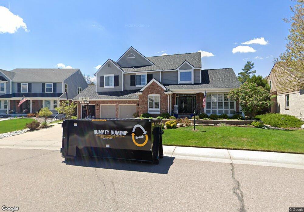
8689 S Forrest Dr Littleton, CO 80126
Northridge NeighborhoodEstimated Value: $1,075,000 - $1,153,000
4
Beds
4
Baths
4,886
Sq Ft
$226/Sq Ft
Est. Value
About This Home
This home is located at 8689 S Forrest Dr, Littleton, CO 80126 and is currently estimated at $1,103,001, approximately $225 per square foot. 8689 S Forrest Dr is a home located in Douglas County with nearby schools including Cougar Run Elementary School, Cresthill Middle School, and Highlands Ranch High School.
Ownership History
Date
Name
Owned For
Owner Type
Purchase Details
Closed on
Apr 27, 2016
Sold by
Hansard Markham L
Bought by
Barri Adam F and Barri Kristine M
Current Estimated Value
Home Financials for this Owner
Home Financials are based on the most recent Mortgage that was taken out on this home.
Original Mortgage
$417,000
Outstanding Balance
$332,716
Interest Rate
3.73%
Mortgage Type
New Conventional
Estimated Equity
$770,285
Purchase Details
Closed on
May 19, 2004
Sold by
Hansard Markham L and Hansard Joanna B
Bought by
Hansard Markham L
Home Financials for this Owner
Home Financials are based on the most recent Mortgage that was taken out on this home.
Original Mortgage
$496,000
Interest Rate
7.65%
Mortgage Type
New Conventional
Purchase Details
Closed on
May 3, 2004
Sold by
Hansard Markham L and Hansard Joanna B
Bought by
Hansard Markham L
Home Financials for this Owner
Home Financials are based on the most recent Mortgage that was taken out on this home.
Original Mortgage
$496,000
Interest Rate
7.65%
Mortgage Type
New Conventional
Purchase Details
Closed on
May 13, 2000
Sold by
Millsap Don M and Fortunato Carmen Fortunato
Bought by
Hansard Markham L and Hansard Joanna B
Home Financials for this Owner
Home Financials are based on the most recent Mortgage that was taken out on this home.
Original Mortgage
$306,000
Interest Rate
8.62%
Purchase Details
Closed on
Apr 8, 1994
Sold by
April Corp
Bought by
Millsap Don M and Fortunato Carmen
Home Financials for this Owner
Home Financials are based on the most recent Mortgage that was taken out on this home.
Original Mortgage
$203,150
Interest Rate
7.49%
Purchase Details
Closed on
Mar 1, 1994
Sold by
Mission Viejo Company
Bought by
April Corporation
Home Financials for this Owner
Home Financials are based on the most recent Mortgage that was taken out on this home.
Original Mortgage
$203,150
Interest Rate
7.49%
Purchase Details
Closed on
Nov 3, 1993
Sold by
Mission Viejo Co
Bought by
April Corp
Create a Home Valuation Report for This Property
The Home Valuation Report is an in-depth analysis detailing your home's value as well as a comparison with similar homes in the area
Home Values in the Area
Average Home Value in this Area
Purchase History
| Date | Buyer | Sale Price | Title Company |
|---|---|---|---|
| Barri Adam F | $652,000 | Land Title Guarantee | |
| Hansard Markham L | -- | -- | |
| Hansard Markham L | -- | Chicago Title Co | |
| Hansard Markham L | $382,500 | Guardian Title | |
| Millsap Don M | $295,436 | Land Title | |
| April Corporation | -- | -- | |
| April Corp | $660,500 | -- |
Source: Public Records
Mortgage History
| Date | Status | Borrower | Loan Amount |
|---|---|---|---|
| Open | Barri Adam F | $417,000 | |
| Previous Owner | Hansard Markham L | $496,000 | |
| Previous Owner | Hansard Markham L | $306,000 | |
| Previous Owner | Millsap Don M | $203,150 |
Source: Public Records
Tax History Compared to Growth
Tax History
| Year | Tax Paid | Tax Assessment Tax Assessment Total Assessment is a certain percentage of the fair market value that is determined by local assessors to be the total taxable value of land and additions on the property. | Land | Improvement |
|---|---|---|---|---|
| 2024 | $6,846 | $76,320 | $15,740 | $60,580 |
| 2023 | $6,834 | $76,320 | $15,740 | $60,580 |
| 2022 | $4,751 | $52,000 | $11,330 | $40,670 |
| 2021 | $4,942 | $52,000 | $11,330 | $40,670 |
| 2020 | $4,629 | $49,910 | $10,890 | $39,020 |
| 2019 | $4,646 | $49,910 | $10,890 | $39,020 |
| 2018 | $4,012 | $42,450 | $11,050 | $31,400 |
| 2017 | $3,653 | $42,450 | $11,050 | $31,400 |
| 2016 | $3,665 | $41,800 | $11,870 | $29,930 |
| 2015 | $1,872 | $41,800 | $11,870 | $29,930 |
| 2014 | $1,713 | $35,330 | $7,160 | $28,170 |
Source: Public Records
Map
Nearby Homes
- 8685 Meadow Creek Dr
- 8586 Meadow Creek Dr
- 8320 Stonybridge Cir
- 8495 Pebble Creek Way Unit 102
- 72 Falcon Hills Dr
- 3825 Canyon Ranch Rd Unit 203
- 3855 Canyon Ranch Rd Unit 104
- 8834 Blue Mountain Place
- 3756 E Phillips Cir
- 8254 S Fillmore Way
- 8259 S Fillmore Cir
- 8228 S Fillmore Cir
- 8174 S Fillmore Way
- 8181 S Fillmore Cir
- 4179 E Phillips Place
- 4605 Copeland Loop Unit 204
- 4605 Copeland Loop Unit 104
- 8909 Copeland St
- 8925 Copeland St
- 8734 Pochard St
- 8689 Forrest Dr
- 8685 Forrest Dr
- 8693 Forrest Dr
- 8695 Meadow Creek Dr
- 3339 Meadow Creek Place
- 3351 Meadow Creek Place
- 8681 Forrest Dr
- 3327 Meadow Creek Place
- 3375 Meadow Creek Place
- 8688 Forrest Dr
- 3387 Meadow Creek Place
- 8705 Forrest Dr
- 8684 Forrest Dr
- 8677 Forrest Dr
- 3315 Meadow Creek Place
- 8696 Meadow Creek Dr
- 3411 Meadow Creek Place
- 8675 Meadow Creek Dr
- 8680 Forrest Dr
- 8711 Forrest Dr