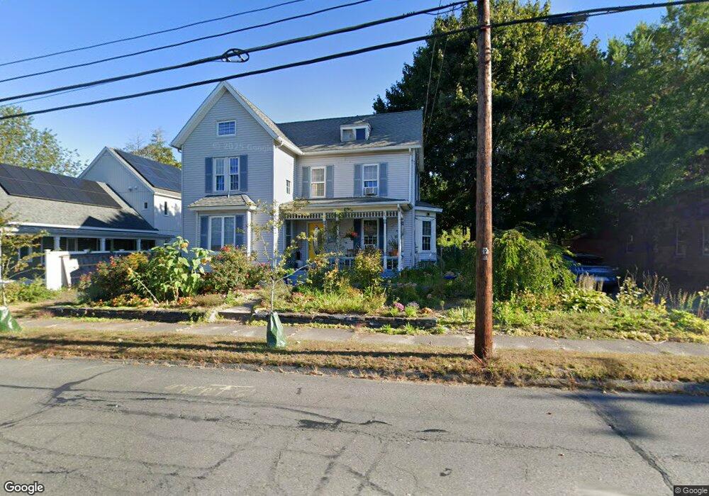
87 Locust St Northampton, MA 01060
Estimated Value: $543,219 - $687,000
4
Beds
2
Baths
2,149
Sq Ft
$285/Sq Ft
Est. Value
About This Home
This home is located at 87 Locust St, Northampton, MA 01060 and is currently estimated at $612,055, approximately $284 per square foot. 87 Locust St is a home located in Hampshire County with nearby schools including Northampton High School, The Montessori School of Northampton, and Lander Grinspoon Academy.
Ownership History
Date
Name
Owned For
Owner Type
Purchase Details
Closed on
Aug 20, 2007
Sold by
Breakstone Kevin T
Bought by
Hesse Caryn R and Hesse Kent A
Current Estimated Value
Home Financials for this Owner
Home Financials are based on the most recent Mortgage that was taken out on this home.
Original Mortgage
$272,000
Outstanding Balance
$172,305
Interest Rate
6.67%
Mortgage Type
Purchase Money Mortgage
Estimated Equity
$439,750
Purchase Details
Closed on
Nov 5, 2004
Sold by
Bramucci Michelle A and Bramucci Richard C
Bought by
Breakstone Kevin T
Home Financials for this Owner
Home Financials are based on the most recent Mortgage that was taken out on this home.
Original Mortgage
$254,400
Interest Rate
5.71%
Mortgage Type
Purchase Money Mortgage
Purchase Details
Closed on
Mar 21, 2003
Sold by
Bramucci Michelle A and Korash Michelle A
Bought by
Bramucci Michelle A and Bramucci Richard C
Home Financials for this Owner
Home Financials are based on the most recent Mortgage that was taken out on this home.
Original Mortgage
$207,200
Interest Rate
5.9%
Mortgage Type
Purchase Money Mortgage
Purchase Details
Closed on
Sep 30, 1999
Sold by
Grabowski Theresa A and Izbicki Thomas S
Bought by
Bramucci Richard and Korash Michelle A
Home Financials for this Owner
Home Financials are based on the most recent Mortgage that was taken out on this home.
Original Mortgage
$122,500
Interest Rate
7.85%
Mortgage Type
Purchase Money Mortgage
Create a Home Valuation Report for This Property
The Home Valuation Report is an in-depth analysis detailing your home's value as well as a comparison with similar homes in the area
Home Values in the Area
Average Home Value in this Area
Purchase History
| Date | Buyer | Sale Price | Title Company |
|---|---|---|---|
| Hesse Caryn R | $340,000 | -- | |
| Breakstone Kevin T | $318,000 | -- | |
| Bramucci Michelle A | -- | -- | |
| Bramucci Richard | $110,000 | -- |
Source: Public Records
Mortgage History
| Date | Status | Borrower | Loan Amount |
|---|---|---|---|
| Open | Hesse Caryn R | $272,000 | |
| Previous Owner | Bramucci Richard | $254,400 | |
| Previous Owner | Bramucci Richard | $207,200 | |
| Previous Owner | Bramucci Richard | $153,000 | |
| Previous Owner | Bramucci Richard | $122,500 |
Source: Public Records
Tax History Compared to Growth
Tax History
| Year | Tax Paid | Tax Assessment Tax Assessment Total Assessment is a certain percentage of the fair market value that is determined by local assessors to be the total taxable value of land and additions on the property. | Land | Improvement |
|---|---|---|---|---|
| 2025 | $6,394 | $459,000 | $122,400 | $336,600 |
| 2024 | $6,436 | $423,700 | $122,400 | $301,300 |
| 2023 | $6,409 | $404,600 | $111,200 | $293,400 |
| 2022 | $5,698 | $318,500 | $111,200 | $207,300 |
| 2021 | $5,366 | $308,900 | $106,200 | $202,700 |
| 2020 | $5,190 | $308,900 | $106,200 | $202,700 |
| 2019 | $5,136 | $295,700 | $106,200 | $189,500 |
| 2018 | $5,071 | $297,600 | $106,200 | $191,400 |
| 2017 | $4,967 | $297,600 | $106,200 | $191,400 |
| 2016 | $4,809 | $297,600 | $106,200 | $191,400 |
| 2015 | $4,445 | $281,300 | $106,200 | $175,100 |
| 2014 | $4,329 | $281,300 | $106,200 | $175,100 |
Source: Public Records
Map
Nearby Homes
- 0 Terrace Ln
- 152 S Main St Unit 4
- 63 Riverside Dr
- 61 Woodlawn Ave
- 76 Cooke Ave
- 74 Barrett St Unit 105
- 14 Arlington St
- 11 Norwood Ave
- 37 Landy Ave
- 76 Maple St
- 67 Park St Unit A
- 67 Park St Unit B
- 67 Park St Unit D
- 225 Nonotuck St Unit C
- 218 Elm St
- 325 Riverside Dr
- 321 Riverside Dr
- 49 Kensington Ave
- 84 N Main St
- 37 Finn St