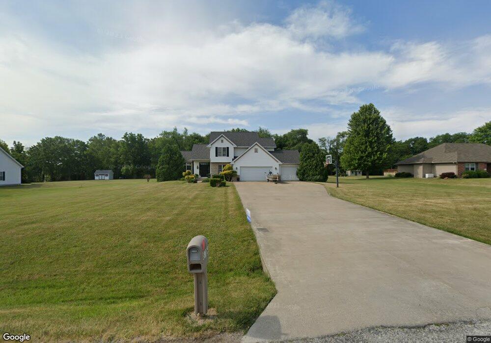
8706 W Bartell Dr Mapleton, IL 61547
Estimated Value: $335,338 - $393,000
4
Beds
3
Baths
2,214
Sq Ft
$161/Sq Ft
Est. Value
About This Home
This home is located at 8706 W Bartell Dr, Mapleton, IL 61547 and is currently estimated at $357,085, approximately $161 per square foot. 8706 W Bartell Dr is a home located in Peoria County with nearby schools including Limestone Walters Elementary School and Limestone Community High School.
Ownership History
Date
Name
Owned For
Owner Type
Purchase Details
Closed on
Jun 15, 2011
Sold by
Kelly Cloyd
Bought by
Hopper Derrick R and Hopper Angela G
Current Estimated Value
Home Financials for this Owner
Home Financials are based on the most recent Mortgage that was taken out on this home.
Original Mortgage
$187,000
Interest Rate
2.87%
Mortgage Type
New Conventional
Create a Home Valuation Report for This Property
The Home Valuation Report is an in-depth analysis detailing your home's value as well as a comparison with similar homes in the area
Purchase History
| Date | Buyer | Sale Price | Title Company |
|---|---|---|---|
| Hopper Derrick R | $237,000 | Attorney Only | |
| Hopper Derrick R | $237,000 | -- |
Source: Public Records
Mortgage History
| Date | Status | Borrower | Loan Amount |
|---|---|---|---|
| Previous Owner | Hopper Derrick R | $187,000 | |
| Closed | Hopper Derrick R | $187,000 |
Source: Public Records
Tax History
| Year | Tax Paid | Tax Assessment Tax Assessment Total Assessment is a certain percentage of the fair market value that is determined by local assessors to be the total taxable value of land and additions on the property. | Land | Improvement |
|---|---|---|---|---|
| 2024 | $7,652 | $95,660 | $15,230 | $80,430 |
| 2023 | $7,131 | $88,570 | $14,100 | $74,470 |
| 2022 | $6,747 | $83,500 | $13,050 | $70,450 |
| 2021 | $6,500 | $80,290 | $12,550 | $67,740 |
| 2020 | $6,129 | $78,710 | $12,300 | $66,410 |
| 2019 | $6,142 | $78,710 | $12,300 | $66,410 |
| 2018 | $5,994 | $78,690 | $12,300 | $66,390 |
| 2017 | $6,210 | $79,480 | $12,420 | $67,060 |
| 2016 | $6,062 | $80,290 | $12,550 | $67,740 |
| 2015 | $5,862 | $78,710 | $12,300 | $66,410 |
| 2014 | $5,849 | $77,340 | $12,080 | $65,260 |
| 2013 | -- | $77,340 | $12,080 | $65,260 |
Source: Public Records
Map
Nearby Homes
- 9320 W Lake Camelot Dr
- 5221 S Cameron Ln
- 9522 W Excalibur Ct
- 9811 W Lake Lancelot Dr
- 409 W Lake Camelot Dr
- 9517 W Whittingham Point
- 9913 W Guinivere Dr
- 0 W Country View Dr
- 3 W Country View Dr
- 7426 W Lancaster Rd
- 9622 W Lancaster Rd
- 4304 S Arn Ct
- 2400 S Cameron Ln
- 10520 W Sir Durham Ct
- 6820 W Pfeiffer Rd
- 15 Sandalwood Ln
- 4202 W Smithville Rd
- 3912 S Paramount Rd
- LOT 26 W Sunflower Dr
- Lot 2 S Gerdes Rd
- 8714 W Bartell Dr
- 8626 W Bartell Dr
- 8625 W Pfeiffer Rd
- 8709 W Pfeiffer Rd
- 8722 W Bartell Dr
- 8616 W Bartell Dr
- 8707 W Bartell Dr
- 8719 W Pfeiffer Rd
- 8711 W Bartell Dr
- 8629 W Bartell Dr
- Lot 36 Bartell
- 8615 W Bartell Dr
- 8801 W Pfeiffer Rd
- 8804 W Bartell Dr
- 8721 W Bartell Dr
- 8604 W Bartell Dr
- 8605 W Pfeiffer Rd
- 8624 W Pfeiffer Rd
- 8614 Bartell Dr
- 0 Pointe Dr Unit 1133481
Your Personal Tour Guide
Ask me questions while you tour the home.