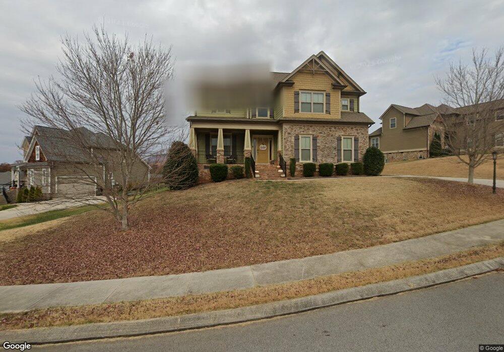
8779 McKenzie Farm Dr Unit 35 Ooltewah, TN 37363
Estimated Value: $490,000 - $621,000
4
Beds
3
Baths
2,250
Sq Ft
$242/Sq Ft
Est. Value
About This Home
This home is located at 8779 McKenzie Farm Dr Unit 35, Ooltewah, TN 37363 and is currently estimated at $543,483, approximately $241 per square foot. 8779 McKenzie Farm Dr Unit 35 is a home located in Hamilton County with nearby schools including Ooltewah Elementary School, Hunter Middle School, and Ooltewah High School.
Ownership History
Date
Name
Owned For
Owner Type
Purchase Details
Closed on
Jun 14, 2013
Sold by
Fatherson Partnership Two
Bought by
Deberry John R and Deberry Kelly
Current Estimated Value
Home Financials for this Owner
Home Financials are based on the most recent Mortgage that was taken out on this home.
Original Mortgage
$270,750
Outstanding Balance
$191,994
Interest Rate
3.42%
Mortgage Type
New Conventional
Estimated Equity
$351,489
Purchase Details
Closed on
Jun 5, 2009
Sold by
Athens Federal Community Bank
Bought by
Fatherson Partnership Two
Purchase Details
Closed on
Mar 31, 2009
Sold by
Mckenzie Farm Llc
Bought by
Athens Federal Community Bank and Citizens National Bank
Create a Home Valuation Report for This Property
The Home Valuation Report is an in-depth analysis detailing your home's value as well as a comparison with similar homes in the area
Home Values in the Area
Average Home Value in this Area
Purchase History
| Date | Buyer | Sale Price | Title Company |
|---|---|---|---|
| Deberry John R | $285,000 | Pioneer Title Agency Inc | |
| Fatherson Partnership Two | $4,500,000 | None Available | |
| Athens Federal Community Bank | $4,385,875 | None Available |
Source: Public Records
Mortgage History
| Date | Status | Borrower | Loan Amount |
|---|---|---|---|
| Open | Deberry John R | $270,750 | |
| Closed | Fatherson Partnership Two | $0 |
Source: Public Records
Tax History Compared to Growth
Tax History
| Year | Tax Paid | Tax Assessment Tax Assessment Total Assessment is a certain percentage of the fair market value that is determined by local assessors to be the total taxable value of land and additions on the property. | Land | Improvement |
|---|---|---|---|---|
| 2024 | $1,897 | $84,775 | $0 | $0 |
| 2023 | $1,906 | $84,775 | $0 | $0 |
| 2022 | $1,906 | $84,775 | $0 | $0 |
| 2021 | $1,906 | $84,775 | $0 | $0 |
| 2020 | $2,162 | $77,850 | $0 | $0 |
| 2019 | $2,162 | $77,850 | $0 | $0 |
| 2018 | $2,162 | $77,850 | $0 | $0 |
| 2017 | $2,162 | $77,850 | $0 | $0 |
| 2016 | $2,074 | $0 | $0 | $0 |
| 2015 | $2,074 | $74,675 | $0 | $0 |
| 2014 | $2,074 | $0 | $0 | $0 |
Source: Public Records
Map
Nearby Homes
- 7608 Maplehurst Dr
- 7515 Highborne Ln
- 9058 Knolling Loop
- 7505 Highborne Ln
- 8987 Knolling Loop
- 9089 Knolling Loop
- 8760 Snowy Owl Rd
- 7320 Dividing Way
- 7382 Dividing Way
- 7552 Snow Line Ln
- 7541 Snow Cone Way
- 7556 Snow Line Ln
- 7573 Snow Line Ln
- 7549 Snow Cone Way
- 8930 Knolling Loop
- 7564 Snow Line Ln
- 7538 Snow Cone Way
- 7568 Snow Line Ln
- 8918 Knolling Loop
- 7559 Snow Cone Way
- 8779 McKenzie Farm Dr
- 8761 McKenzie Farm Dr
- 8761 McKenzie Farm Dr Unit 34
- 8793 McKenzie Farm Dr
- 8793 McKenzie Farm Dr Unit 36
- 7537 Sandy Creek Ln
- 7537 Sandy Creek Ln
- 7537 Sandy Creek Ln Unit Lot 39
- 7537 Sandy Creek Ln Unit 39
- 8778 McKenzie Farm Dr
- 8778 McKenzie Farm Dr Unit 14
- 8786 McKenzie Farm Dr
- 8786 McKenzie Farm Dr Unit 15
- 8794 McKenzie Farm Dr
- 8794 McKenzie Farm Dr Unit 16
- 8762 McKenzie Farm Dr
- 8762 McKenzie Farm Dr Unit 12
- 8770 McKenzie Farm Dr
- 8770 McKenzie Farm Dr Unit 13
- 8753 McKenzie Farm Dr