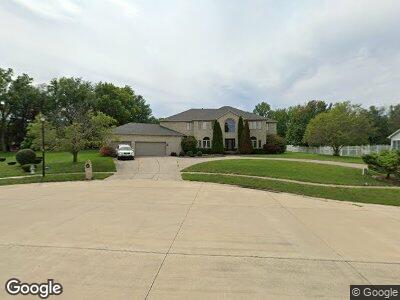
879 Jasons Way Forsyth, IL 62535
Estimated Value: $524,071 - $679,000
5
Beds
6
Baths
6,322
Sq Ft
$94/Sq Ft
Est. Value
About This Home
This home is located at 879 Jasons Way, Forsyth, IL 62535 and is currently estimated at $596,018, approximately $94 per square foot. 879 Jasons Way is a home located in Macon County with nearby schools including Warrensburg-Latham Elementary School, Warrensburg-Latham Middle School, and Warrensburg-Latham High School.
Ownership History
Date
Name
Owned For
Owner Type
Purchase Details
Closed on
Jan 19, 2021
Sold by
Jones Brandie N
Bought by
Lincoln Land Illinois Land Trust
Current Estimated Value
Home Financials for this Owner
Home Financials are based on the most recent Mortgage that was taken out on this home.
Original Mortgage
$297,000
Interest Rate
2.71%
Mortgage Type
New Conventional
Create a Home Valuation Report for This Property
The Home Valuation Report is an in-depth analysis detailing your home's value as well as a comparison with similar homes in the area
Home Values in the Area
Average Home Value in this Area
Purchase History
| Date | Buyer | Sale Price | Title Company |
|---|---|---|---|
| Lincoln Land Illinois Land Trust | $470,000 | -- | |
| Lincoln Land Illinois Land | $445,000 | None Available |
Source: Public Records
Mortgage History
| Date | Status | Borrower | Loan Amount |
|---|---|---|---|
| Previous Owner | Lincoln Land Illinois Land | $297,000 | |
| Previous Owner | Patel Gaurang | $403,000 | |
| Previous Owner | Patel Guarang | $414,500 | |
| Previous Owner | Patel Gaurang | $417,000 | |
| Previous Owner | Pateel Gaurang | $120,000 | |
| Previous Owner | Patel Gaurang | $210,000 |
Source: Public Records
Tax History Compared to Growth
Tax History
| Year | Tax Paid | Tax Assessment Tax Assessment Total Assessment is a certain percentage of the fair market value that is determined by local assessors to be the total taxable value of land and additions on the property. | Land | Improvement |
|---|---|---|---|---|
| 2024 | $13,798 | $184,380 | $17,904 | $166,476 |
| 2023 | $12,974 | $169,498 | $16,459 | $153,039 |
| 2022 | $13,186 | $157,203 | $15,265 | $141,938 |
| 2021 | $12,004 | $148,333 | $14,273 | $134,060 |
| 2020 | $13,384 | $167,479 | $13,978 | $153,501 |
| 2019 | $13,384 | $167,479 | $13,978 | $153,501 |
| 2018 | $13,296 | $168,677 | $14,078 | $154,599 |
| 2017 | $13,356 | $167,921 | $14,015 | $153,906 |
| 2016 | $13,571 | $168,325 | $14,049 | $154,276 |
| 2015 | $13,228 | $166,329 | $13,882 | $152,447 |
| 2014 | $12,262 | $166,329 | $13,882 | $152,447 |
| 2013 | $12,716 | $166,329 | $13,882 | $152,447 |
Source: Public Records
Map
Nearby Homes
- 95 Hickory Point Ct
- 160 Hickory Point Ct
- 1250 W Hickory Point Rd
- 5307 Yavapai Dr
- 5354 N Macarthur Rd
- 749 Christopher Dr
- 981 W Forsyth Rd
- 957 W Forsyth Rd
- 120 Shadow Ridge Blvd
- 7 McDonald Ave
- 157 Shadow Ridge Blvd
- 335 Loma Dr
- 164 Shadow Ridge Blvd
- 1104 Clement Ave
- 1302 Clement Ave
- 0 Route 51 Unit 6241333
- 4624 Redbud Ct
- 4554 Nicklaus Ct
- 4605 Redbud Ct
- 4545 Havenwood Dr
- 879 Jasons Way
- 879 Jason's Way
- 892 Cara Chris Ln
- 867 Jasons Way
- 870 Jasons Way
- 882 Jasons Way
- 847 Jasons Way
- 873 Cara Chris Ln
- 881 Cara Chris Ln
- 858 Jasons Way
- 865 Cara Chris Ln
- 950 Cara Chris Ln
- 857 Cara Chris Ln
- 881 S Oakland Ave
- 893 S Oakland Ave
- 869 S Oakland Ave
- 850 Jasons Way
- 857 S Oakland Ave
- 1120 W Weaver Rd
- 1124 W Weaver Rd