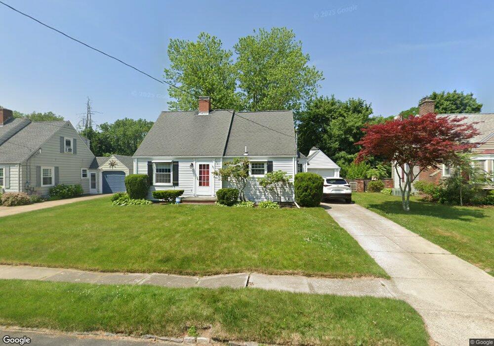
88 Roslyn Ave Cranston, RI 02910
Forest Hills NeighborhoodEstimated Value: $395,000 - $440,000
3
Beds
2
Baths
1,239
Sq Ft
$334/Sq Ft
Est. Value
About This Home
This home is located at 88 Roslyn Ave, Cranston, RI 02910 and is currently estimated at $413,723, approximately $333 per square foot. 88 Roslyn Ave is a home located in Providence County with nearby schools including Woodridge Elementary School, Western Hills Middle School, and Cranston High School West.
Ownership History
Date
Name
Owned For
Owner Type
Purchase Details
Closed on
Apr 15, 2015
Sold by
Mellor David D and Marzocchi Deana M
Bought by
Mellor David D
Current Estimated Value
Purchase Details
Closed on
Jul 11, 2014
Sold by
Mellor David D
Bought by
Mellor David D and Marzocchi Deana M
Purchase Details
Closed on
Jul 31, 2007
Sold by
Feeney Karen A
Bought by
Mellor David D
Home Financials for this Owner
Home Financials are based on the most recent Mortgage that was taken out on this home.
Original Mortgage
$157,600
Interest Rate
6.78%
Mortgage Type
Purchase Money Mortgage
Create a Home Valuation Report for This Property
The Home Valuation Report is an in-depth analysis detailing your home's value as well as a comparison with similar homes in the area
Home Values in the Area
Average Home Value in this Area
Purchase History
| Date | Buyer | Sale Price | Title Company |
|---|---|---|---|
| Mellor David D | -- | -- | |
| Mellor David D | -- | -- | |
| Mellor David D | $228,000 | -- |
Source: Public Records
Mortgage History
| Date | Status | Borrower | Loan Amount |
|---|---|---|---|
| Previous Owner | Mellor David D | $157,000 | |
| Previous Owner | Mellor David D | $160,000 | |
| Previous Owner | Mellor David D | $157,600 |
Source: Public Records
Tax History Compared to Growth
Tax History
| Year | Tax Paid | Tax Assessment Tax Assessment Total Assessment is a certain percentage of the fair market value that is determined by local assessors to be the total taxable value of land and additions on the property. | Land | Improvement |
|---|---|---|---|---|
| 2025 | $4,369 | $314,800 | $103,900 | $210,900 |
| 2024 | $4,222 | $310,200 | $103,900 | $206,300 |
| 2023 | $4,196 | $222,000 | $71,700 | $150,300 |
| 2022 | $4,109 | $222,000 | $71,700 | $150,300 |
| 2021 | $3,996 | $222,000 | $71,700 | $150,300 |
| 2020 | $3,948 | $190,100 | $75,100 | $115,000 |
| 2019 | $3,948 | $190,100 | $75,100 | $115,000 |
| 2018 | $3,857 | $190,100 | $75,100 | $115,000 |
| 2017 | $3,781 | $164,800 | $68,200 | $96,600 |
| 2016 | $3,700 | $164,800 | $68,200 | $96,600 |
| 2015 | $3,700 | $164,800 | $68,200 | $96,600 |
| 2014 | $3,654 | $160,000 | $68,200 | $91,800 |
Source: Public Records
Map
Nearby Homes
- 46 Roslyn Ave
- 55 Columbus Blvd
- 111 Belgium St
- 63 Packard St
- 80 Packard St
- 174 Gansett Ave
- 92 Rhode Island St
- 12 Stevens Rd
- 0 Fiat Ave
- 210 Crescent Ave
- 7 Cleveland Ave
- 1455 Park Ave Unit 3
- 145 Harmon Ave
- 0 Doane St
- 74 Leslie St
- 18 Standish Ave
- 166 Midwood St
- 9 Southern St
- 2 Gansett Ave
- 14 New Hampshire St