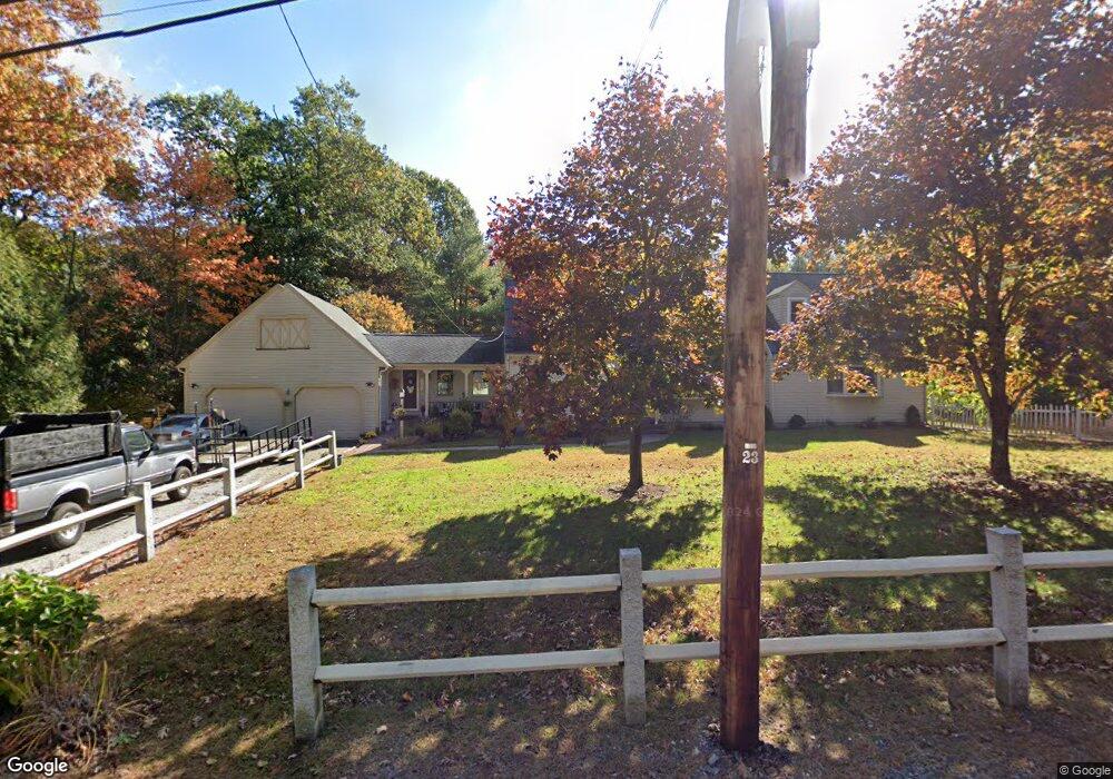
89 Miller St Franklin, MA 02038
Estimated Value: $791,000 - $921,000
4
Beds
2
Baths
2,904
Sq Ft
$295/Sq Ft
Est. Value
About This Home
This home is located at 89 Miller St, Franklin, MA 02038 and is currently estimated at $856,200, approximately $294 per square foot. 89 Miller St is a home located in Norfolk County with nearby schools including Helen Keller Elementary School, Annie Sullivan Middle School, and Franklin High School.
Ownership History
Date
Name
Owned For
Owner Type
Purchase Details
Closed on
Apr 8, 1981
Bought by
Foley Thomas J and Foley Judith G
Current Estimated Value
Create a Home Valuation Report for This Property
The Home Valuation Report is an in-depth analysis detailing your home's value as well as a comparison with similar homes in the area
Purchase History
| Date | Buyer | Sale Price | Title Company |
|---|---|---|---|
| Foley Thomas J | $61,000 | -- |
Source: Public Records
Mortgage History
| Date | Status | Borrower | Loan Amount |
|---|---|---|---|
| Open | Foley Thomas J | $324,290 | |
| Closed | Foley Thomas J | $144,130 | |
| Closed | Foley Thomas J | $40,000 |
Source: Public Records
Tax History
| Year | Tax Paid | Tax Assessment Tax Assessment Total Assessment is a certain percentage of the fair market value that is determined by local assessors to be the total taxable value of land and additions on the property. | Land | Improvement |
|---|---|---|---|---|
| 2025 | $7,801 | $671,300 | $339,300 | $332,000 |
| 2024 | $7,771 | $659,100 | $339,300 | $319,800 |
| 2023 | $7,470 | $593,800 | $289,100 | $304,700 |
| 2022 | $6,980 | $496,800 | $227,700 | $269,100 |
| 2021 | $6,907 | $471,500 | $255,700 | $215,800 |
| 2020 | $6,538 | $450,600 | $245,200 | $205,400 |
| 2019 | $6,452 | $440,100 | $234,800 | $205,300 |
| 2018 | $6,018 | $410,800 | $226,400 | $184,400 |
| 2017 | $5,745 | $394,000 | $209,600 | $184,400 |
| 2016 | $5,625 | $387,900 | $224,400 | $163,500 |
| 2015 | $5,590 | $376,700 | $213,200 | $163,500 |
| 2014 | $5,040 | $348,800 | $187,000 | $161,800 |
Source: Public Records
Map
Nearby Homes
- 7 Glenwood Rd
- 70 Daniels St
- 43 Grey Wolf Dr Unit 13
- 41 Myrtle St
- 10 Silver Fox Rd
- 312 Eagles Nest Way Unit 312
- 20 Waites Crossing
- 19 Waites Crossing
- 13 Waites Crossing
- 14 Waites Crossing
- 10 Populatic Street Extension
- 0 Toils End Rd
- 9 Elliot Mills Unit 5
- 8 Elliot Mills Unit 30
- 5 Elliot Mills Unit 3
- 7 Elliot Mills Unit 4
- 10 Elliot Mills Unit 29
- 12 Ariana Ln
- 204 Lincoln St
- 91 Oliver Pond Cir Unit 3
Your Personal Tour Guide
Ask me questions while you tour the home.