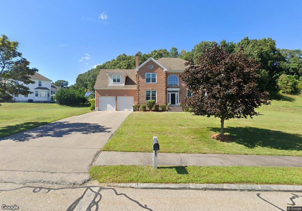
9 Red Gate Ln Franklin, MA 02038
Estimated Value: $910,462 - $1,105,000
4
Beds
3
Baths
2,495
Sq Ft
$396/Sq Ft
Est. Value
About This Home
This home is located at 9 Red Gate Ln, Franklin, MA 02038 and is currently estimated at $988,116, approximately $396 per square foot. 9 Red Gate Ln is a home located in Norfolk County with nearby schools including Gerald M. Parmenter Elementary School, Remington Middle School, and Franklin High School.
Ownership History
Date
Name
Owned For
Owner Type
Purchase Details
Closed on
Jun 25, 2001
Sold by
Thomas Martin J
Bought by
Obrien Kevin R and Obrien Ellen A
Current Estimated Value
Home Financials for this Owner
Home Financials are based on the most recent Mortgage that was taken out on this home.
Original Mortgage
$398,700
Outstanding Balance
$153,090
Interest Rate
7.09%
Mortgage Type
Purchase Money Mortgage
Estimated Equity
$835,026
Purchase Details
Closed on
Jan 14, 1997
Sold by
Del Mar Dev Corp
Bought by
Thomas Martin J
Home Financials for this Owner
Home Financials are based on the most recent Mortgage that was taken out on this home.
Original Mortgage
$217,400
Interest Rate
7.46%
Mortgage Type
Purchase Money Mortgage
Create a Home Valuation Report for This Property
The Home Valuation Report is an in-depth analysis detailing your home's value as well as a comparison with similar homes in the area
Purchase History
| Date | Buyer | Sale Price | Title Company |
|---|---|---|---|
| Obrien Kevin R | $443,000 | -- | |
| Thomas Martin J | $287,400 | -- |
Source: Public Records
Mortgage History
| Date | Status | Borrower | Loan Amount |
|---|---|---|---|
| Open | Thomas Martin J | $83,997 | |
| Open | Thomas Martin J | $398,700 | |
| Previous Owner | Thomas Martin J | $217,400 |
Source: Public Records
Tax History
| Year | Tax Paid | Tax Assessment Tax Assessment Total Assessment is a certain percentage of the fair market value that is determined by local assessors to be the total taxable value of land and additions on the property. | Land | Improvement |
|---|---|---|---|---|
| 2025 | $9,614 | $827,400 | $374,200 | $453,200 |
| 2024 | $9,899 | $839,600 | $374,200 | $465,400 |
| 2023 | $9,090 | $722,600 | $317,900 | $404,700 |
| 2022 | $9,607 | $683,800 | $331,100 | $352,700 |
| 2021 | $8,852 | $604,200 | $277,400 | $326,800 |
| 2020 | $8,539 | $588,500 | $277,400 | $311,100 |
| 2019 | $8,579 | $585,200 | $274,500 | $310,700 |
| 2018 | $8,197 | $559,500 | $280,300 | $279,200 |
| 2017 | $8,284 | $568,200 | $289,000 | $279,200 |
| 2016 | $7,856 | $541,800 | $264,900 | $276,900 |
| 2015 | $7,316 | $493,000 | $216,100 | $276,900 |
| 2014 | $7,359 | $509,300 | $232,400 | $276,900 |
Source: Public Records
Map
Nearby Homes
- 18 Northern Spy Rd
- 3 Oak View Terrace Unit 3
- 65 Jordan Rd
- 62 Uncas Ave
- 60 Uncas Ave
- 66 Uncas Ave
- 68 Uncas Ave
- 76 Uncas Ave
- 80 Uncas Ave
- 82 Uncas Ave
- 30 Partridge View Ln S
- 37 Cross St
- 99 Summer St
- 90 E Central St Unit 304
- 9 Elliot Mills Unit 5
- 8 Elliot Mills Unit 30
- 5 Elliot Mills Unit 3
- 7 Elliot Mills Unit 4
- 10 Elliot Mills Unit 29
- 50 Reed Fulton Ave Unit Lot 61
- 13 Lot # 13 Red Gate Ln
- 15 Red Gate Ln
- 5 Red Gate Ln
- 19 Red Gate Ln
- 580 E Central St
- 14 Red Gate Ln
- 10 Red Gate Ln
- 6 Red Gate Ln
- 578 E Central St
- 1 Red Gate Ln
- 606 E Central St
- 23 Red Gate Ln
- 18 Red Gate Ln
- 601 E Central St
- 27 Red Gate Ln
- 550 E Central St
- 540 E Central St
- 28 Red Gate Ln
- 6 Northern Spy Rd
- 31 Red Gate Ln
Your Personal Tour Guide
Ask me questions while you tour the home.