9 State Highway Hh Poplar Bluff, MO 63901
Estimated Value: $110,000 - $188,000
--
Bed
--
Bath
1,743
Sq Ft
$83/Sq Ft
Est. Value
About This Home
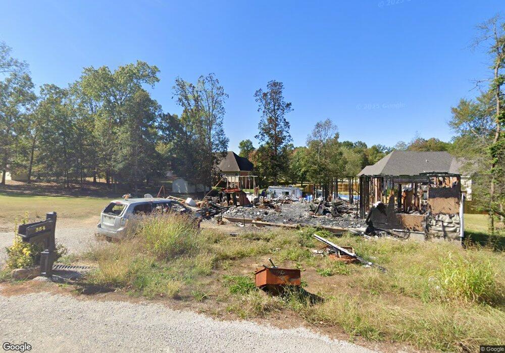
This home is located at 9 State Highway Hh, Poplar Bluff, MO 63901 and is currently estimated at $145,000, approximately $83 per square foot. 9 State Highway Hh is a home with nearby schools including Oak Grove Elementary School, Poplar Bluff Fifth & Sixth Grade Center, and Poplar Bluff Junior High School.
Ownership History
Date
Name
Owned For
Owner Type
Purchase Details
Closed on
Mar 4, 2025
Sold by
Sheriff Of Butler County Missouri
Bought by
Hayes Dan and Hayes Teresa
Current Estimated Value
Purchase Details
Closed on
Nov 6, 2024
Sold by
Butler County Sheriff
Bought by
Hayes Dan and Hayes Teresa
Purchase Details
Closed on
Sep 20, 2013
Sold by
Ozark Foothills Development Association
Bought by
Morgan John R
Home Financials for this Owner
Home Financials are based on the most recent Mortgage that was taken out on this home.
Original Mortgage
$104,860
Interest Rate
3.12%
Mortgage Type
USDA
Create a Home Valuation Report for This Property
The Home Valuation Report is an in-depth analysis detailing your home's value as well as a comparison with similar homes in the area
Home Values in the Area
Average Home Value in this Area
Purchase History
| Date | Buyer | Sale Price | Title Company |
|---|---|---|---|
| Hayes Dan | -- | None Listed On Document | |
| Hayes Dan | $5,654 | None Listed On Document | |
| Hayes Dan | $5,654 | None Listed On Document | |
| Morgan John R | -- | None Available |
Source: Public Records
Mortgage History
| Date | Status | Borrower | Loan Amount |
|---|---|---|---|
| Previous Owner | Morgan John R | $104,860 |
Source: Public Records
Tax History Compared to Growth
Tax History
| Year | Tax Paid | Tax Assessment Tax Assessment Total Assessment is a certain percentage of the fair market value that is determined by local assessors to be the total taxable value of land and additions on the property. | Land | Improvement |
|---|---|---|---|---|
| 2024 | $106 | $2,380 | $0 | $0 |
| 2023 | $106 | $2,380 | $0 | $0 |
| 2022 | $1,099 | $24,720 | $0 | $0 |
| 2021 | $1,099 | $24,720 | $0 | $0 |
| 2020 | $1,116 | $24,720 | $0 | $0 |
| 2019 | $1,115 | $24,720 | $0 | $0 |
| 2018 | $1,115 | $24,720 | $0 | $0 |
| 2017 | -- | $24,720 | $0 | $0 |
| 2016 | -- | $24,720 | $0 | $0 |
| 2015 | -- | $24,720 | $0 | $0 |
| 2014 | -- | $14,390 | $0 | $0 |
| 2012 | $36 | $480 | $0 | $0 |
Source: Public Records
Map
Nearby Homes
- 6115 Greenbriar Dr
- 223 Timberway Dr
- 547 County Road 448
- Lot 11 Timber Way Dr
- 103 Lincoln Dr
- 1460 Victoria Rd
- 5100 Crabapple Ln
- 210 Berkshire Dr
- 135 County Road 4415
- 148 County Road 4421
- 2163 Township Line Rd
- 46 Red Cedar Blvd
- 267 Misty Lake Rd
- 205 Batson Lake Ln
- 1149 Mistletoe Ln
- 125 Terrell Ave
- 3011 Wolf Run
- 383 Golden Ln
- 381 Golden Ln
- 54 Century Ave Unit 54
- 356 Meadow View Dr
- 371 Meadow View
- 353 Meadow View Dr
- 369 Meadow View Dr
- 6130 Greenbriar Dr
- 6120 Greenbriar Dr
- 169 Bluebird Ln
- 362 Meadow View Dr
- 361 Meadow View Dr
- 231 County Road 445
- 6110 Greenbriar Dr
- 6135 Greenbriar Dr
- 345 Meadow View Dr
- 365 Meadow View Dr
- 366 Meadow View Dr
- 141 County Road 445
- 235 Rocky Ridge Dr
- 241 Rocky Ridge Ln
- 325 Meadow View Dr
- 6105 Greenbriar Dr