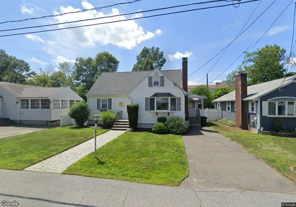
9 Tuttle Ln Saugus, MA 01906
Pleasant Hills NeighborhoodEstimated Value: $620,000 - $707,000
3
Beds
2
Baths
1,320
Sq Ft
$501/Sq Ft
Est. Value
About This Home
This home is located at 9 Tuttle Ln, Saugus, MA 01906 and is currently estimated at $661,928, approximately $501 per square foot. 9 Tuttle Ln is a home located in Essex County with nearby schools including Saugus High School, Pioneer Charter School Of Science II, and Melrose Montessori School.
Ownership History
Date
Name
Owned For
Owner Type
Purchase Details
Closed on
Dec 3, 2004
Sold by
Campanile Robert M
Bought by
Campanile Robert M
Current Estimated Value
Purchase Details
Closed on
Jan 21, 1992
Sold by
Walsh Nicholas Est
Bought by
Campanile Robert
Home Financials for this Owner
Home Financials are based on the most recent Mortgage that was taken out on this home.
Original Mortgage
$30,000
Interest Rate
8.57%
Mortgage Type
Purchase Money Mortgage
Create a Home Valuation Report for This Property
The Home Valuation Report is an in-depth analysis detailing your home's value as well as a comparison with similar homes in the area
Home Values in the Area
Average Home Value in this Area
Purchase History
| Date | Buyer | Sale Price | Title Company |
|---|---|---|---|
| Campanile Robert M | -- | -- | |
| Campanile Robert | $133,000 | -- |
Source: Public Records
Mortgage History
| Date | Status | Borrower | Loan Amount |
|---|---|---|---|
| Previous Owner | Campanile Robert | $30,000 |
Source: Public Records
Tax History
| Year | Tax Paid | Tax Assessment Tax Assessment Total Assessment is a certain percentage of the fair market value that is determined by local assessors to be the total taxable value of land and additions on the property. | Land | Improvement |
|---|---|---|---|---|
| 2025 | $5,955 | $557,600 | $299,300 | $258,300 |
| 2024 | $5,712 | $536,300 | $282,200 | $254,100 |
| 2023 | $5,529 | $491,000 | $248,000 | $243,000 |
| 2022 | $5,353 | $445,700 | $227,400 | $218,300 |
| 2021 | $5,036 | $408,100 | $197,500 | $210,600 |
| 2020 | $4,656 | $390,600 | $188,100 | $202,500 |
| 2019 | $4,463 | $366,400 | $171,000 | $195,400 |
| 2018 | $4,012 | $346,500 | $165,900 | $180,600 |
| 2017 | $3,758 | $311,900 | $154,800 | $157,100 |
| 2016 | $3,529 | $289,300 | $154,500 | $134,800 |
| 2015 | $3,312 | $275,500 | $147,100 | $128,400 |
| 2014 | $3,091 | $266,200 | $147,100 | $119,100 |
Source: Public Records
Map
Nearby Homes
- 7 Tuttle Ln
- 11 Tuttle Ln
- 5 Tuttle Ln
- 15 Tuttle Ln
- 10 Bennett Hwy Unit 3
- 10 Bennett Hwy
- 10 Bennett Hwy Unit B1
- 10 Bennett Hwy Unit 202
- 9 Enmore Rd
- 34 Felton St Unit 103
- 34 Felton St Unit 203
- 34 Felton St Unit 101
- 34 Felton St Unit 202
- 7 Enmore Rd
- 5 Enmore Rd
- 11 Enmore Rd
- 15 Enmore Rd
- 26 Felton St
- 30 Felton St
- 22 Felton St
Your Personal Tour Guide
Ask me questions while you tour the home.