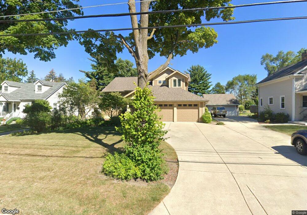
901 Pershing Ave Wheaton, IL 60189
Southeast Wheaton NeighborhoodEstimated Value: $602,405 - $729,000
Studio
1
Bath
2,732
Sq Ft
$246/Sq Ft
Est. Value
About This Home
This home is located at 901 Pershing Ave, Wheaton, IL 60189 and is currently estimated at $672,601, approximately $246 per square foot. 901 Pershing Ave is a home located in DuPage County with nearby schools including Lincoln Elementary School, Edison Middle School, and Wheaton Warrenville South High School.
Ownership History
Date
Name
Owned For
Owner Type
Purchase Details
Closed on
Sep 22, 2016
Sold by
Sturm Robert K and Hayden Eileen A
Bought by
Allen Keith
Current Estimated Value
Purchase Details
Closed on
Nov 30, 1998
Sold by
Munsterman Arnett F and Munsterman Ruth M
Bought by
Allen Keith R and Allen Phyllis D
Purchase Details
Closed on
Dec 6, 1996
Sold by
Munsterman Arnette F and Munsterman Ruth M
Bought by
Allen Keith R and Allen Phyllis D
Create a Home Valuation Report for This Property
The Home Valuation Report is an in-depth analysis detailing your home's value as well as a comparison with similar homes in the area
Home Values in the Area
Average Home Value in this Area
Purchase History
| Date | Buyer | Sale Price | Title Company |
|---|---|---|---|
| Allen Keith | $155,000 | Ctic | |
| Allen Keith R | $160,000 | -- | |
| Allen Keith R | $40,000 | -- |
Source: Public Records
Tax History
| Year | Tax Paid | Tax Assessment Tax Assessment Total Assessment is a certain percentage of the fair market value that is determined by local assessors to be the total taxable value of land and additions on the property. | Land | Improvement |
|---|---|---|---|---|
| 2024 | $10,666 | $181,483 | $46,237 | $135,246 |
| 2023 | $10,208 | $167,050 | $42,560 | $124,490 |
| 2022 | $10,171 | $157,870 | $40,220 | $117,650 |
| 2021 | $10,130 | $154,130 | $39,270 | $114,860 |
| 2020 | $10,095 | $152,690 | $38,900 | $113,790 |
| 2019 | $9,855 | $148,660 | $37,870 | $110,790 |
| 2018 | $10,967 | $162,420 | $35,680 | $126,740 |
| 2017 | $10,793 | $156,420 | $34,360 | $122,060 |
| 2016 | $10,637 | $150,170 | $32,990 | $117,180 |
| 2015 | $10,541 | $143,260 | $31,470 | $111,790 |
| 2014 | $10,996 | $141,620 | $29,760 | $111,860 |
| 2013 | $10,714 | $142,050 | $29,850 | $112,200 |
Source: Public Records
Map
Nearby Homes
- 510 S President St
- 1500 Pershing Ave
- 840 Sheldon Ct Unit B
- 715 S Naperville Rd
- 1000 S Lorraine Rd Unit 214
- 1607 E Indiana St
- 1026 Briarcliffe Blvd
- 421 E Willow Ave
- 1344 S Lorraine Rd Unit C
- 1318 Gamon Rd
- 119 S Williston St
- 123 S Blanchard St
- 1818 E Indiana St
- 302 Roscommon Ct
- 1581 Groton Ln
- 353 E Liberty Dr
- 1542 Castlewood Dr
- 1551 Briarcliffe Blvd
- 909 S Wheaton Ave
- 110 E Farnham Ln
- 905 Pershing Ave
- 867 Pershing Ave
- 823 Pershing Ave
- 907 Pershing Ave
- 913 Pershing Ave
- 815 Pershing Ave
- 904 Pershing Ave
- 824 Pershing Ave
- 906 Pershing Ave
- 816 Pershing Ave
- 809 Pershing Ave
- 910 Pershing Ave
- 816 S President St
- 812 S President St
- 916 Pershing Ave
- 805 Pershing Ave
- 805 Pershing Ave Unit West Room
- 808 S President St
- 803 Pershing Ave
- 804 S President St
Your Personal Tour Guide
Ask me questions while you tour the home.