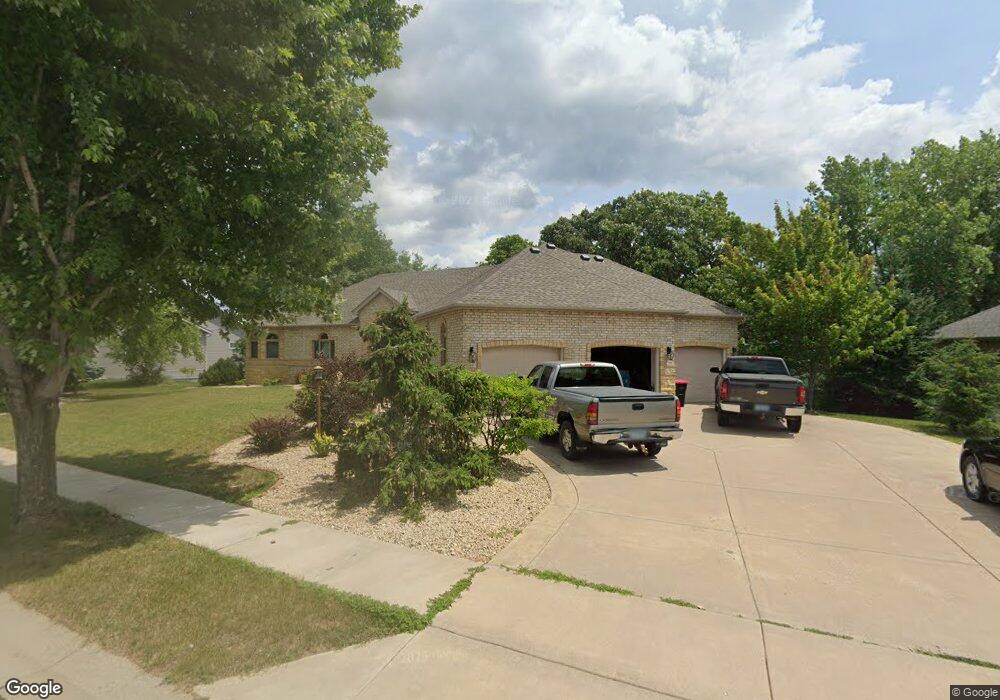
905 Snowbird Dr Red Wing, MN 55066
Estimated Value: $456,000 - $670,000
3
Beds
3
Baths
3,454
Sq Ft
$158/Sq Ft
Est. Value
About This Home
This home is located at 905 Snowbird Dr, Red Wing, MN 55066 and is currently estimated at $545,480, approximately $157 per square foot. 905 Snowbird Dr is a home located in Goodhue County with nearby schools including Burnside Elementary School, Sunnyside Elementary School, and Twin Bluff Middle School.
Ownership History
Date
Name
Owned For
Owner Type
Purchase Details
Closed on
Jun 4, 2019
Sold by
Saul William D and Saul Gwen D
Bought by
Rehder Patrick J and Rehder Michele R
Current Estimated Value
Purchase Details
Closed on
Jun 20, 2016
Sold by
Saul William D and Saul Gwen D
Bought by
Saul William D and Saul Gwen D
Purchase Details
Closed on
Feb 12, 2003
Sold by
Mn Development Inc
Bought by
Biermann Homes Inc
Purchase Details
Closed on
Aug 28, 2000
Sold by
Charlson Arnold G and Charlson Janet B
Bought by
M B Development Inc
Create a Home Valuation Report for This Property
The Home Valuation Report is an in-depth analysis detailing your home's value as well as a comparison with similar homes in the area
Home Values in the Area
Average Home Value in this Area
Purchase History
| Date | Buyer | Sale Price | Title Company |
|---|---|---|---|
| Rehder Patrick J | $415,000 | -- | |
| Saul William D | -- | Attorney | |
| Biermann Homes Inc | $66,900 | -- | |
| M B Development Inc | $267,500 | -- |
Source: Public Records
Tax History
| Year | Tax Paid | Tax Assessment Tax Assessment Total Assessment is a certain percentage of the fair market value that is determined by local assessors to be the total taxable value of land and additions on the property. | Land | Improvement |
|---|---|---|---|---|
| 2025 | $7,884 | $576,900 | $63,000 | $513,900 |
| 2024 | $7,884 | $567,300 | $63,100 | $504,200 |
| 2023 | $4,074 | $567,800 | $63,100 | $504,700 |
| 2022 | $7,412 | $563,900 | $63,100 | $500,800 |
| 2021 | $6,954 | $495,600 | $81,500 | $414,100 |
| 2020 | $6,882 | $471,000 | $81,500 | $389,500 |
| 2019 | $6,896 | $434,700 | $81,500 | $353,200 |
| 2018 | $5,896 | $440,800 | $81,500 | $359,300 |
| 2017 | $5,738 | $399,100 | $81,500 | $317,600 |
| 2016 | $5,730 | $423,200 | $111,600 | $311,600 |
| 2015 | $5,522 | $411,400 | $111,600 | $299,800 |
| 2014 | -- | $408,800 | $125,500 | $283,300 |
Source: Public Records
Map
Nearby Homes
- 4786 Mount Hood Ln
- 921 Snowbird Dr
- 910 Snowbird Dr
- 914 Snowbird Dr
- 4739 Big Sky Ct
- 853 Aurora Cir
- 4958 Chalet Ct
- 912 Aurora Cir
- 980 Aurora Cir
- 135 Kingswood Dr
- 1056 Birch Ave
- 5542 Cannon Dale Ct
- 3557 Skyline Dr
- 3560 Graves Dr
- 3429 Helen Ln
- 131 Rose Ave
- 128 Charles Ave
- 186 Sargent Dr
- 113 Burnside Ave S
- 1125 Hewitt Blvd
- 899 Snowbird Dr
- Lot 12 Snowbird
- 909 Snowbird Dr
- 0 Snowbird Dr Unit 4194542
- 00 Snowbird-Drive-
- 0 Snowbird Dr Unit 4403267
- 887 Snowbird Dr
- 898 Snowbird Dr
- 933 Snowbird Dr
- 4794 Mount Hood Ln
- 550 Aspen Ave
- 875 Snowbird Dr
- 880 Snowbird Dr
- 924 Snowbird Dr
- 4791 Mount Hood Ln
- 00 Snowbird Dr
- 4736 Big Sky Ct
- 542 Aspen Ave
- 930 Snowbird Dr
- 610 Aspen Ave
Your Personal Tour Guide
Ask me questions while you tour the home.