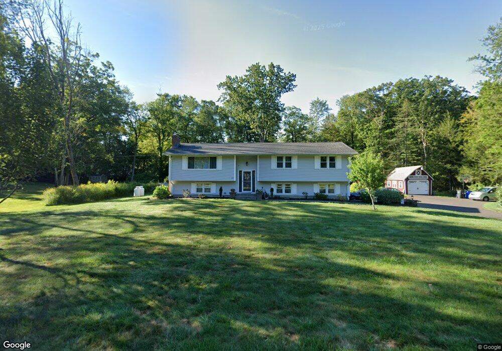
91 Blue Ridge Dr Somers, CT 06071
Estimated Value: $425,000 - $508,000
3
Beds
3
Baths
1,390
Sq Ft
$346/Sq Ft
Est. Value
About This Home
This home is located at 91 Blue Ridge Dr, Somers, CT 06071 and is currently estimated at $480,563, approximately $345 per square foot. 91 Blue Ridge Dr is a home located in Tolland County with nearby schools including Somers Elementary School, Mabelle B. Avery Middle School, and Somers High School.
Ownership History
Date
Name
Owned For
Owner Type
Purchase Details
Closed on
May 13, 2005
Sold by
Walsh Kevin and Walsh Sue
Bought by
Kowal Brian and Kowal Priscilla
Current Estimated Value
Purchase Details
Closed on
Aug 5, 2002
Sold by
Miller Steven and Miller Keri
Bought by
Walsh Kevin and Walsh Sue
Purchase Details
Closed on
May 2, 2000
Sold by
Reed Howard and Reed Betty
Bought by
Miller Steven and Miller Keri
Create a Home Valuation Report for This Property
The Home Valuation Report is an in-depth analysis detailing your home's value as well as a comparison with similar homes in the area
Home Values in the Area
Average Home Value in this Area
Purchase History
| Date | Buyer | Sale Price | Title Company |
|---|---|---|---|
| Kowal Brian | $254,000 | -- | |
| Kowal Brian | $254,000 | -- | |
| Walsh Kevin | $218,500 | -- | |
| Walsh Kevin | $218,500 | -- | |
| Miller Steven | $165,900 | -- | |
| Miller Steven | $165,900 | -- |
Source: Public Records
Mortgage History
| Date | Status | Borrower | Loan Amount |
|---|---|---|---|
| Open | Miller Steven | $221,229 | |
| Closed | Miller Steven | $230,921 |
Source: Public Records
Tax History Compared to Growth
Tax History
| Year | Tax Paid | Tax Assessment Tax Assessment Total Assessment is a certain percentage of the fair market value that is determined by local assessors to be the total taxable value of land and additions on the property. | Land | Improvement |
|---|---|---|---|---|
| 2025 | $6,081 | $201,300 | $69,500 | $131,800 |
| 2024 | $5,830 | $201,300 | $69,500 | $131,800 |
| 2023 | $5,699 | $201,300 | $69,500 | $131,800 |
| 2022 | $5,548 | $201,300 | $69,500 | $131,800 |
| 2021 | $5,367 | $201,300 | $69,500 | $131,800 |
| 2020 | $5,378 | $196,500 | $69,500 | $127,000 |
| 2019 | $5,107 | $186,600 | $75,400 | $111,200 |
| 2018 | $5,107 | $186,600 | $75,400 | $111,200 |
| 2017 | $4,753 | $186,600 | $75,400 | $111,200 |
| 2016 | $4,519 | $186,600 | $75,400 | $111,200 |
| 2015 | $4,024 | $172,200 | $82,500 | $89,700 |
| 2014 | $4,024 | $172,200 | $82,500 | $89,700 |
Source: Public Records
Map
Nearby Homes
- 35 Therese Dr
- 49 Bridle Path Dr
- 557 Hall Hill Rd
- 35 Cantlewood Dr
- 603 Hall Hill Rd
- 31 Meade Ln
- 4 Copley Cir
- 2 Meacham Dr Unit 2
- 144 Watchaug Rd
- 155 Sheridan Rd
- 436 Taylor Rd
- 11 Northfield Rd
- 138 Main St
- 192 Main St
- 355 Pinehurst Dr
- 42 Schneider Rd
- 20 Halon Terrace Unit Lot 11
- 80 Pease Rd
- 14 High Meadow Cir
- 0 Rockingham Cir
- 98 Blue Ridge Dr
- 95 Blue Ridge Dr
- 83 Blue Ridge Dr
- 76 Blue Ridge Dr
- 77 Blue Ridge Dr
- 95 Loubier Dr
- 94 Loubier Dr
- 70 Blue Ridge Dr
- 67 Blue Ridge Dr
- 86 Loubier Dr
- 89 Loubier Dr
- 80 Loubier Dr
- 62 Blue Ridge Dr
- 85 Mcculloch Dr
- 83 Loubier Dr
- 172 Wrights Brook Dr
- 75 Mcculloch Dr
- 55 Blue Ridge Dr
- 56 Blue Ridge Dr
- 190 Wrights Brook Dr