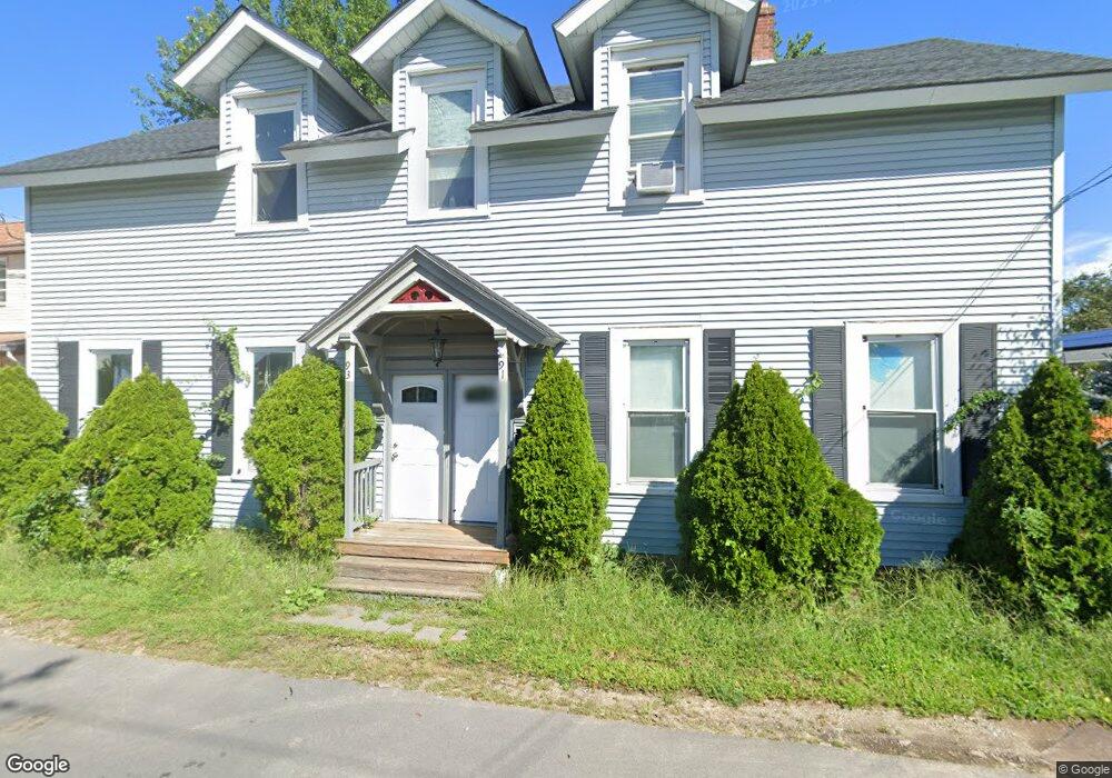
91 Oak Ave Unit 93 Riverside, RI 02915
Riverside NeighborhoodEstimated Value: $562,000 - $631,000
8
Beds
2
Baths
3,100
Sq Ft
$191/Sq Ft
Est. Value
About This Home
This home is located at 91 Oak Ave Unit 93, Riverside, RI 02915 and is currently estimated at $593,580, approximately $191 per square foot. 91 Oak Ave Unit 93 is a home located in Providence County with nearby schools including East Providence High School, St Mary Academy-Bay View, and The Gordon School.
Ownership History
Date
Name
Owned For
Owner Type
Purchase Details
Closed on
Dec 22, 2016
Sold by
Oertel Charles W
Bought by
Oertel Charles W
Current Estimated Value
Purchase Details
Closed on
Oct 8, 2013
Sold by
Oertel Charles W
Bought by
Cest T T and Cest Oertel
Purchase Details
Closed on
Feb 19, 2004
Sold by
Razumau Andrei and Razumau Ina
Bought by
Prunty William
Purchase Details
Closed on
Nov 25, 2003
Sold by
Doughty Steven
Bought by
Razumau Andrei
Create a Home Valuation Report for This Property
The Home Valuation Report is an in-depth analysis detailing your home's value as well as a comparison with similar homes in the area
Home Values in the Area
Average Home Value in this Area
Purchase History
| Date | Buyer | Sale Price | Title Company |
|---|---|---|---|
| Oertel Charles W | -- | -- | |
| Wood Stephen F | -- | -- | |
| Oertel Charles W | -- | -- | |
| Cest T T | -- | -- | |
| Cest T T | -- | -- | |
| Prunty William | $300,000 | -- | |
| Prunty William | $300,000 | -- | |
| Razumau Andrei | $250,000 | -- | |
| Razumau Andrei | $250,000 | -- |
Source: Public Records
Mortgage History
| Date | Status | Borrower | Loan Amount |
|---|---|---|---|
| Previous Owner | Razumau Andrei | $252,000 | |
| Previous Owner | Razumau Andrei | $108,000 |
Source: Public Records
Tax History
| Year | Tax Paid | Tax Assessment Tax Assessment Total Assessment is a certain percentage of the fair market value that is determined by local assessors to be the total taxable value of land and additions on the property. | Land | Improvement |
|---|---|---|---|---|
| 2025 | $7,370 | $563,900 | $98,200 | $465,700 |
| 2024 | $6,014 | $392,300 | $81,900 | $310,400 |
| 2023 | $5,790 | $392,300 | $81,900 | $310,400 |
| 2022 | $5,974 | $273,300 | $53,400 | $219,900 |
| 2021 | $5,876 | $273,300 | $53,300 | $220,000 |
| 2020 | $5,627 | $273,300 | $53,300 | $220,000 |
| 2019 | $5,471 | $273,300 | $53,300 | $220,000 |
| 2018 | $5,196 | $227,100 | $53,500 | $173,600 |
| 2017 | $5,080 | $227,100 | $53,500 | $173,600 |
| 2016 | $5,055 | $227,100 | $53,500 | $173,600 |
| 2015 | $5,212 | $227,100 | $54,500 | $172,600 |
| 2014 | $5,212 | $227,100 | $54,500 | $172,600 |
Source: Public Records
Map
Nearby Homes
- 33 Pine St Unit 35
- 56 Knowlton St
- 27 Hoppin Ave
- 2 Sprague Ave
- 25 Arnold St
- 79 Sherman St
- 48 Read St
- 102 Willett Ave
- 43 Bullocks Point Ave Unit 4A
- 43 Bullocks Point Ave Unit 8B
- 33 Bullocks Point Ave Unit 5C
- 25 Bullocks Point Ave Unit 5C
- 41 Whitcomb Rd
- 47 Dartmouth Ave
- 6 Fuller Ave
- 525 Willett Ave
- 63 Indian Rd
- 63 Cul de Sac Way
- 14 Lottie Dr
- 131 Anson Dr
Your Personal Tour Guide
Ask me questions while you tour the home.