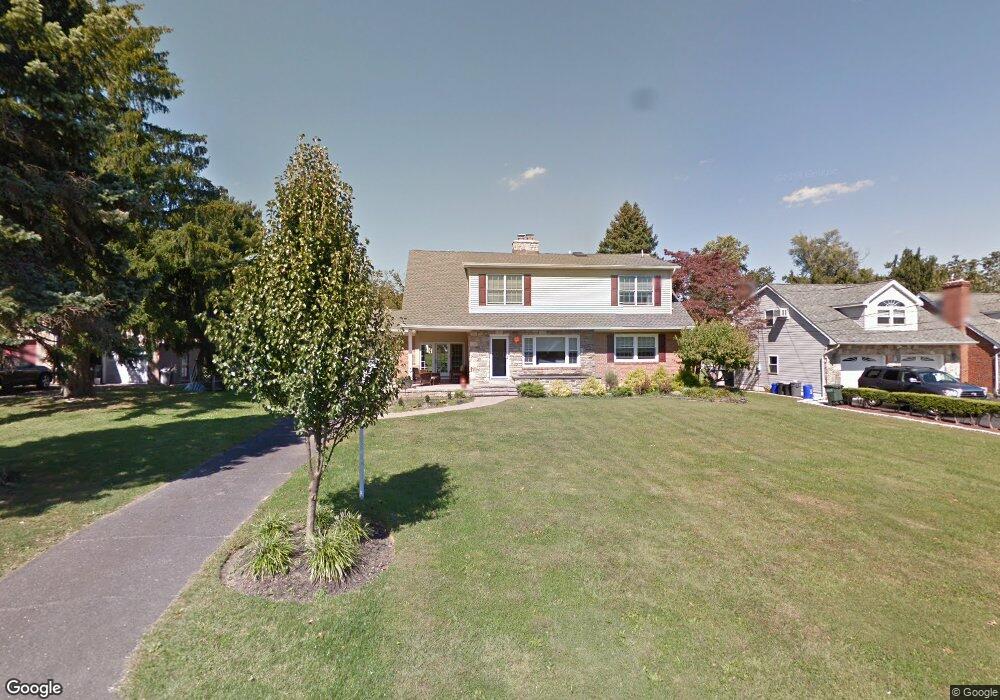
912 E Maple Dr Southampton, PA 18966
Estimated Value: $466,000 - $707,000
4
Beds
2
Baths
2,598
Sq Ft
$230/Sq Ft
Est. Value
About This Home
This home is located at 912 E Maple Dr, Southampton, PA 18966 and is currently estimated at $597,167, approximately $229 per square foot. 912 E Maple Dr is a home located in Bucks County with nearby schools including Davis Elementary School, Klinger Middle School, and William Tennent High School.
Ownership History
Date
Name
Owned For
Owner Type
Purchase Details
Closed on
Jun 24, 2003
Sold by
Leonhardt Harold A
Bought by
Rosenfeld Matthew and Rosenfeld Megan
Current Estimated Value
Home Financials for this Owner
Home Financials are based on the most recent Mortgage that was taken out on this home.
Original Mortgage
$155,000
Outstanding Balance
$65,726
Interest Rate
5.34%
Mortgage Type
Purchase Money Mortgage
Estimated Equity
$531,441
Purchase Details
Closed on
May 20, 1993
Bought by
Wunderlich Anna Mae
Create a Home Valuation Report for This Property
The Home Valuation Report is an in-depth analysis detailing your home's value as well as a comparison with similar homes in the area
Home Values in the Area
Average Home Value in this Area
Purchase History
We collect this data history from publicly available records. To have your information removed, we recommend requesting removal directly through your county’s website.
| Date | Buyer | Sale Price | Title Company |
|---|---|---|---|
| Rosenfeld Matthew | $195,000 | -- | |
| Wunderlich Anna Mae | -- | -- |
Source: Public Records
Mortgage History
We collect this data history from publicly available records. To have your information removed, we recommend requesting removal directly through your county’s website.
| Date | Status | Borrower | Loan Amount |
|---|---|---|---|
| Open | Rosenfeld Matthew | $155,000 | |
| Closed | Rosenfeld Matthew | $10,000 |
Source: Public Records
Tax History
| Year | Tax Paid | Tax Assessment Tax Assessment Total Assessment is a certain percentage of the fair market value that is determined by local assessors to be the total taxable value of land and additions on the property. | Land | Improvement |
|---|---|---|---|---|
| 2025 | $6,789 | $31,740 | $6,680 | $25,060 |
| 2024 | $6,789 | $31,740 | $6,680 | $25,060 |
| 2023 | $6,582 | $31,740 | $6,680 | $25,060 |
| 2022 | $6,444 | $31,740 | $6,680 | $25,060 |
| 2021 | $6,327 | $31,740 | $6,680 | $25,060 |
| 2020 | $6,240 | $31,740 | $6,680 | $25,060 |
| 2019 | $6,010 | $31,740 | $6,680 | $25,060 |
| 2018 | $5,872 | $31,740 | $6,680 | $25,060 |
| 2017 | $5,706 | $31,740 | $6,680 | $25,060 |
| 2016 | $5,706 | $31,740 | $6,680 | $25,060 |
| 2015 | -- | $31,740 | $6,680 | $25,060 |
| 2014 | -- | $31,740 | $6,680 | $25,060 |
Source: Public Records
Map
Nearby Homes
- 1007 Fawn Dr
- 1038 Fawn Dr
- 905 Pebble Ln
- 633 Provident Rd
- 1086 Gravel Hill Rd
- 649 Provident Rd
- 670 Amalia Ln
- 578 Kutcher Rd
- 681 Provident Rd
- 653 Provident Rd
- 657 Provident Rd
- 665 Provident Rd
- 1555 Fieldwood Rd
- 704 Steamboat Station Unit 704
- 1027 Rozel Ave
- 1609 Mcnelis Dr
- 1022 Rozel Ave
- 756 Street Rd Unit 1
- 445 Nicholas Dr
- 522 Jason Dr
- 918 E Maple Dr
- 924 E Maple Dr
- 893 Central Ave
- 887 Central Ave
- 906 E Maple Dr
- 899 Central Ave
- 881 Central Ave
- 960 E Maple Dr
- 915 E Maple Dr
- 921 E Maple Dr
- 908 Woodland Dr
- 950 E Maple Dr
- 875 Central Ave
- 927 E Maple Dr
- 901 E Maple Dr
- 894 E Maple Dr
- 933 E Maple Dr
- 896 Central Ave
- 957 E Maple Dr
- 869 Central Ave
Your Personal Tour Guide
Ask me questions while you tour the home.