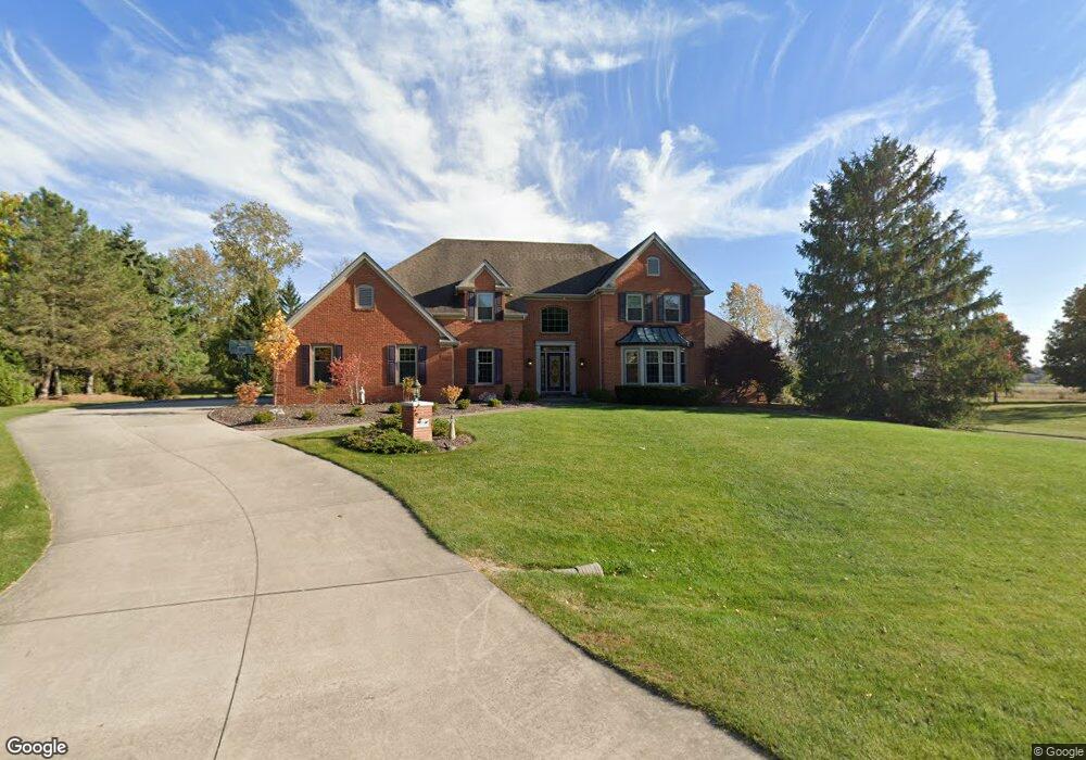
9136 Laurel Hurst Fort Wayne, IN 46835
Arlington Park NeighborhoodEstimated Value: $450,000 - $555,000
4
Beds
5
Baths
3,322
Sq Ft
$154/Sq Ft
Est. Value
About This Home
This home is located at 9136 Laurel Hurst, Fort Wayne, IN 46835 and is currently estimated at $510,936, approximately $153 per square foot. 9136 Laurel Hurst is a home located in Allen County with nearby schools including Arlington Elementary School, Jefferson Middle School, and Northrop High School.
Ownership History
Date
Name
Owned For
Owner Type
Purchase Details
Closed on
Dec 30, 2002
Sold by
Floryan Daniel
Bought by
Pappas Daniel G and Pappas Laura A
Current Estimated Value
Home Financials for this Owner
Home Financials are based on the most recent Mortgage that was taken out on this home.
Original Mortgage
$268,000
Outstanding Balance
$111,054
Interest Rate
6.13%
Estimated Equity
$399,882
Create a Home Valuation Report for This Property
The Home Valuation Report is an in-depth analysis detailing your home's value as well as a comparison with similar homes in the area
Home Values in the Area
Average Home Value in this Area
Purchase History
| Date | Buyer | Sale Price | Title Company |
|---|---|---|---|
| Pappas Daniel G | -- | Three Rivers Title Company I |
Source: Public Records
Mortgage History
| Date | Status | Borrower | Loan Amount |
|---|---|---|---|
| Open | Pappas Daniel G | $268,000 | |
| Closed | Pappas Daniel G | $50,250 |
Source: Public Records
Tax History
| Year | Tax Paid | Tax Assessment Tax Assessment Total Assessment is a certain percentage of the fair market value that is determined by local assessors to be the total taxable value of land and additions on the property. | Land | Improvement |
|---|---|---|---|---|
| 2025 | $5,349 | $495,000 | $70,500 | $424,500 |
| 2024 | $5,168 | $461,000 | $70,500 | $390,500 |
| 2022 | $4,543 | $398,200 | $70,500 | $327,700 |
| 2021 | $3,907 | $344,700 | $57,300 | $287,400 |
| 2020 | $3,731 | $335,200 | $57,300 | $277,900 |
| 2019 | $3,397 | $307,000 | $57,300 | $249,700 |
| 2018 | $3,421 | $307,000 | $57,300 | $249,700 |
| 2017 | $3,371 | $299,600 | $57,300 | $242,300 |
| 2016 | $3,313 | $301,500 | $57,300 | $244,200 |
| 2014 | $3,028 | $291,400 | $57,300 | $234,100 |
| 2013 | $2,902 | $279,800 | $57,300 | $222,500 |
Source: Public Records
Map
Nearby Homes
- 4825 Wheatridge Rd
- 4544 E Shenandoah Cir
- 9434 Maysville Rd
- 3914 Stanton Hall Pkwy
- 9406 Mill Ridge Run
- 10206 Maysville Rd
- 3634 Colorado Ct
- 4803 Oak Creek Ct
- 4118 Stillwood Dr
- 7927 Willowwood Dr
- 3310 Brantley Dr
- 3417 Montana Dr
- 8230 Oklahoma Trail
- 3414 Country Park Ln
- 7728 Wishingwell Ct
- 7219 Putt Ln
- 7530 Glenoak Pkwy
- 6615 Cherry Hill Pkwy
- 5424 Thornbriar Ln
- 6722 Orial Place
- 9202 Laurel Hurst
- 9124 Laurel Hurst
- 9205 Laurel Hurst
- 9208 Laurel Hurst
- 9112 Laurel Hurst
- 9213 Laurel Hurst
- 4522 Wheelock Rd
- 9216 Laurel Hurst
- 9106 Laurel Hurst
- 9105 Laurel Hurst
- 9019 Stellhorn Rd
- 9019 Stellhorn Rd Unit LOT 1
- 9019 Stellhorn Rd Unit LOT 1 and LOT 2
- 4514 Wheelock Rd
- 8951 Stellhorn Rd
- 9219 Laurel Hurst
- 9224 Laurel Hurst
- 4628 Wheelock Rd
- 9034 Laurel Hurst
- 8931 Stellhorn Rd
Your Personal Tour Guide
Ask me questions while you tour the home.