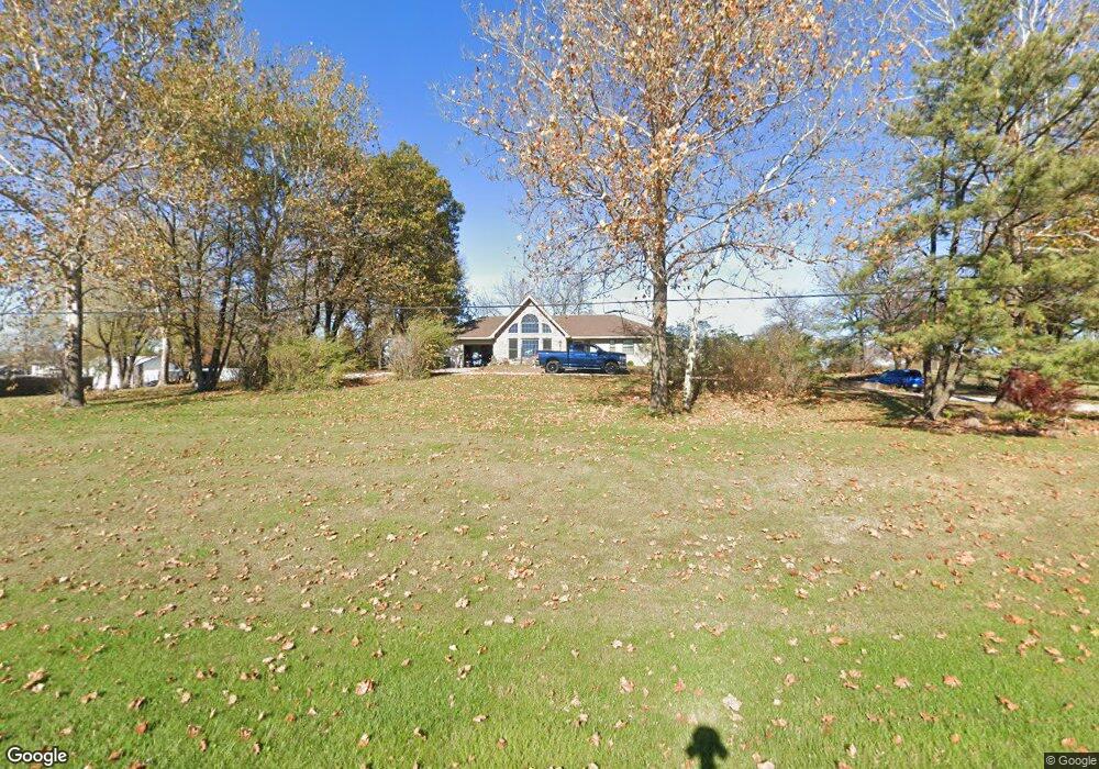
914 4h Rd Lansing, KS 66043
Estimated Value: $375,000 - $424,466
4
Beds
3
Baths
1,672
Sq Ft
$236/Sq Ft
Est. Value
About This Home
This home is located at 914 4h Rd, Lansing, KS 66043 and is currently estimated at $395,155, approximately $236 per square foot. 914 4h Rd is a home located in Leavenworth County with nearby schools including Lansing Elementary School, Lansing Middle 6-8, and Lansing High 9-12.
Ownership History
Date
Name
Owned For
Owner Type
Purchase Details
Closed on
Jun 1, 2004
Bought by
Evans Michael A and Evans Jennifer
Current Estimated Value
Home Financials for this Owner
Home Financials are based on the most recent Mortgage that was taken out on this home.
Original Mortgage
$206,679
Outstanding Balance
$159,708
Interest Rate
6.32%
Mortgage Type
VA
Estimated Equity
$235,447
Create a Home Valuation Report for This Property
The Home Valuation Report is an in-depth analysis detailing your home's value as well as a comparison with similar homes in the area
Home Values in the Area
Average Home Value in this Area
Purchase History
| Date | Buyer | Sale Price | Title Company |
|---|---|---|---|
| Evans Michael A | $221,500 | -- |
Source: Public Records
Mortgage History
| Date | Status | Borrower | Loan Amount |
|---|---|---|---|
| Open | Evans Michael A | $206,679 | |
| Closed | Evans Michael A | $219,750 |
Source: Public Records
Tax History Compared to Growth
Tax History
| Year | Tax Paid | Tax Assessment Tax Assessment Total Assessment is a certain percentage of the fair market value that is determined by local assessors to be the total taxable value of land and additions on the property. | Land | Improvement |
|---|---|---|---|---|
| 2025 | $5,348 | $44,426 | $9,103 | $35,323 |
| 2024 | $5,348 | $42,718 | $10,743 | $31,975 |
| 2023 | $5,348 | $41,074 | $10,743 | $30,331 |
| 2022 | -- | $37,341 | $7,014 | $30,327 |
| 2021 | $0 | $34,201 | $6,179 | $28,022 |
| 2020 | $4,669 | $31,883 | $5,923 | $25,960 |
| 2019 | $4,482 | $30,573 | $5,578 | $24,995 |
| 2018 | $4,116 | $28,116 | $5,359 | $22,757 |
| 2017 | $4,126 | $28,116 | $5,359 | $22,757 |
| 2016 | $3,993 | $27,209 | $5,359 | $21,850 |
| 2015 | -- | $26,807 | $5,359 | $21,448 |
| 2014 | -- | $26,094 | $5,359 | $20,735 |
Source: Public Records
Map
Nearby Homes
- 000 4-H Rd
- 811 4-H Rd
- 722 Bittersweet Rd
- 624 S Bittersweet Ln
- 922 Southfork St
- 527 S Valley Dr
- 1221 S Desoto Rd
- 115 W Gilman Rd
- 875 Clearview Dr
- 73 Continental Dr
- 77 Continental Dr
- 833 Rock Creek Dr
- 901 S Main St
- 705 Rock Creek Dr
- 104 Olive St
- 610 Meadowlark Rd
- 506 1st Terrace
- 202 S Main St
- 124 S Main St
- 131 Rock Creek Loop