Estimated Value: $414,000 - $496,000
4
Beds
4
Baths
1,974
Sq Ft
$224/Sq Ft
Est. Value
About This Home
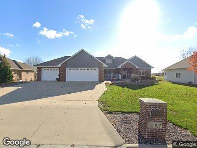
This home is located at 917 Fox Ridge Rd, Dike, IA 50624 and is currently estimated at $442,190, approximately $224 per square foot. 917 Fox Ridge Rd is a home with nearby schools including Dike Elementary School, New Hartford Elementary School, and Dike-New Hartford Junior High School.
Ownership History
Date
Name
Owned For
Owner Type
Purchase Details
Closed on
Feb 1, 2021
Sold by
Albers Michael D and Albers Sandra R
Bought by
Albers Michael D and Mezera-Albers Sandra R
Current Estimated Value
Home Financials for this Owner
Home Financials are based on the most recent Mortgage that was taken out on this home.
Original Mortgage
$158,300
Outstanding Balance
$143,858
Interest Rate
2.1%
Mortgage Type
New Conventional
Estimated Equity
$281,339
Create a Home Valuation Report for This Property
The Home Valuation Report is an in-depth analysis detailing your home's value as well as a comparison with similar homes in the area
Home Values in the Area
Average Home Value in this Area
Purchase History
| Date | Buyer | Sale Price | Title Company |
|---|---|---|---|
| Albers Michael D | -- | -- |
Source: Public Records
Mortgage History
| Date | Status | Borrower | Loan Amount |
|---|---|---|---|
| Open | Albers Michael D | $158,300 | |
| Previous Owner | Albers Michael D | $275,000 | |
| Previous Owner | Albers Michale D | $199,700 | |
| Previous Owner | Albers Michael D | $196,800 | |
| Previous Owner | Albers Michael Dean | $207,000 |
Source: Public Records
Tax History Compared to Growth
Tax History
| Year | Tax Paid | Tax Assessment Tax Assessment Total Assessment is a certain percentage of the fair market value that is determined by local assessors to be the total taxable value of land and additions on the property. | Land | Improvement |
|---|---|---|---|---|
| 2024 | $6,966 | $425,940 | $53,780 | $372,160 |
| 2023 | $6,966 | $425,940 | $53,780 | $372,160 |
| 2022 | $6,496 | $366,300 | $50,950 | $315,350 |
| 2021 | $6,496 | $366,300 | $50,950 | $315,350 |
| 2020 | $6,132 | $342,430 | $50,950 | $291,480 |
| 2019 | $5,780 | $342,430 | $50,950 | $291,480 |
| 2018 | $5,428 | $323,020 | $50,950 | $272,070 |
| 2017 | $5,428 | $323,020 | $50,950 | $272,070 |
| 2016 | $5,674 | $315,950 | $0 | $0 |
| 2015 | $5,674 | $290,070 | $0 | $0 |
| 2014 | $5,334 | $290,070 | $0 | $0 |
Source: Public Records
Map
Nearby Homes
- 607 4th St Unit North unit
- 617 4th St Unit middle unit
- 138 E Elder St
- 4515 Grundy Rd
- 28708 215th St
- 0000 S Ave
- 4718 Wild Horse Dr
- 5417 Fernwood Dr
- 5403 Fernwood Dr
- 5423 Fernwood Dr
- Field 3 S Ave
- Field 4 S Ave
- Field 2 S Ave
- 4016 Wild Horse Dr
- 4010 Wild Horse Dr
- 4004 Wild Horse Dr
- 4007 Wild Horse Dr
- 4517 Granite Ridge Rd
- 4531 Sonoma Dr
- 2823 Arbor Ridge Rd