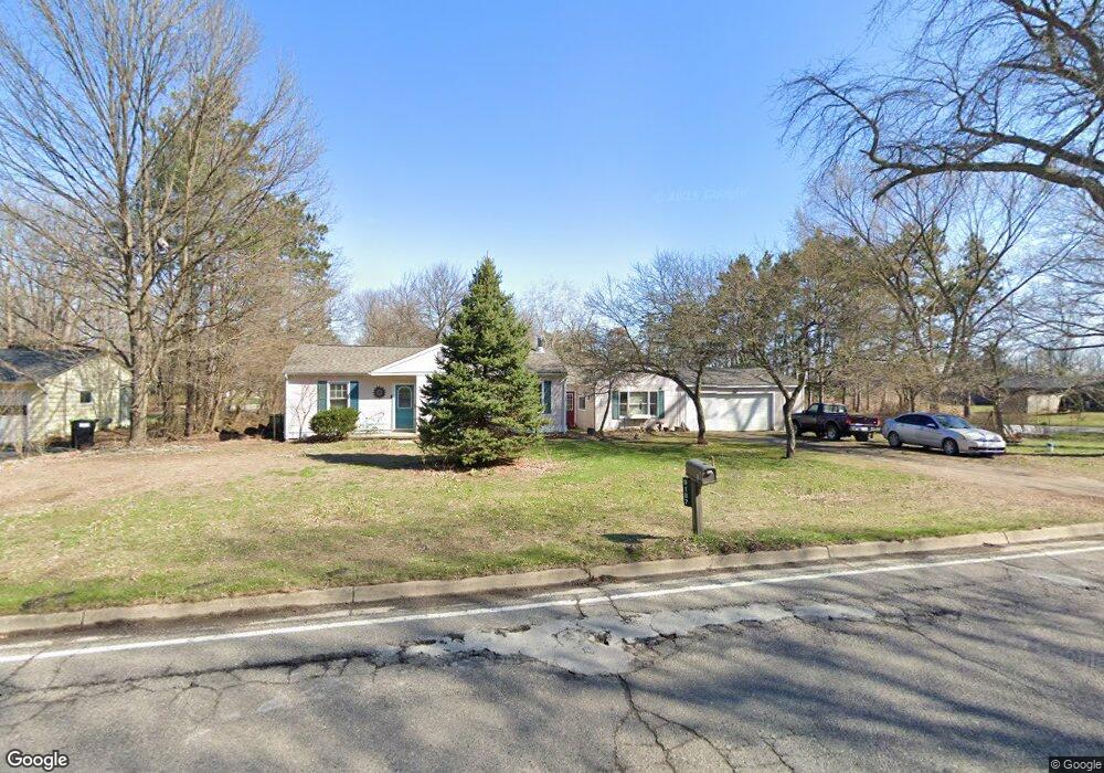
9187 Maltby Rd Brighton, MI 48116
Estimated Value: $321,423 - $367,000
3
Beds
2
Baths
1,702
Sq Ft
$202/Sq Ft
Est. Value
About This Home
This home is located at 9187 Maltby Rd, Brighton, MI 48116 and is currently estimated at $343,606, approximately $201 per square foot. 9187 Maltby Rd is a home located in Livingston County with nearby schools including Hawkins Elementary School, Scranton Middle School, and Brighton High School.
Ownership History
Date
Name
Owned For
Owner Type
Purchase Details
Closed on
Oct 17, 2023
Sold by
Macdougall Patricia
Bought by
Macdougall Patricia
Current Estimated Value
Purchase Details
Closed on
Jul 1, 2000
Sold by
Anguish Timothy and Anguish Kathleen Susan Maher
Bought by
Macdougall Patricia M
Home Financials for this Owner
Home Financials are based on the most recent Mortgage that was taken out on this home.
Original Mortgage
$45,000
Interest Rate
8.55%
Create a Home Valuation Report for This Property
The Home Valuation Report is an in-depth analysis detailing your home's value as well as a comparison with similar homes in the area
Home Values in the Area
Average Home Value in this Area
Purchase History
| Date | Buyer | Sale Price | Title Company |
|---|---|---|---|
| Macdougall Patricia | -- | None Listed On Document | |
| Macdougall Patricia M | $136,000 | American Title Co |
Source: Public Records
Mortgage History
| Date | Status | Borrower | Loan Amount |
|---|---|---|---|
| Previous Owner | Macdougall Patricia M | $45,000 |
Source: Public Records
Tax History Compared to Growth
Tax History
| Year | Tax Paid | Tax Assessment Tax Assessment Total Assessment is a certain percentage of the fair market value that is determined by local assessors to be the total taxable value of land and additions on the property. | Land | Improvement |
|---|---|---|---|---|
| 2025 | $2,178 | $127,100 | $0 | $0 |
| 2024 | $940 | $123,200 | $0 | $0 |
| 2023 | $899 | $109,900 | $0 | $0 |
| 2022 | $1,834 | $94,000 | $0 | $0 |
| 2021 | $1,834 | $94,200 | $0 | $0 |
| 2020 | $1,819 | $96,600 | $0 | $0 |
| 2019 | $1,787 | $94,000 | $0 | $0 |
| 2018 | $1,756 | $83,200 | $0 | $0 |
| 2017 | $1,727 | $83,500 | $0 | $0 |
| 2016 | $1,718 | $85,200 | $0 | $0 |
| 2014 | $1,381 | $67,500 | $0 | $0 |
| 2012 | $1,381 | $57,200 | $0 | $0 |
Source: Public Records
Map
Nearby Homes
- 6891 Somerset Dr
- 00 Cheddar Valley
- Lot 12 Wyndam Ln
- 9353 Old Lee Rd
- 6394 Stephen
- 326 Redmaple Ln Unit 365
- 518 Redmaple Ln Unit 62
- 392 Woodfield Square Ln
- 1242 Baywood Cir
- 8127 Goldenrod Ct
- 396 Spring Brooke Dr Unit 49
- 390 Spring Brooke Dr Unit 390
- 840 Heatheridge Ct Unit 16
- 1017 Elmwood Dr Unit 5
- 0000 Dibrova Dr
- 413 Water Tower Cir Unit 97
- 1016 Pinewood Ct Unit 48
- 8209 Lee Rd
- 0000 Grand River Ave
- 1041 Fairway Trails Dr
- 9177 Maltby Rd
- 6937 Somerset Dr
- 9209 Maltby Rd
- 9169 Maltby Rd
- 9198 Maltby Rd
- 6929 Cheddar Valley Dr
- 9155 Maltby Rd
- 6928 Cheddar Valley Dr
- 0 Somerset Dr
- 6915 Cheddar Valley
- 6915 Cheddar Valley Dr
- 6919 Somerset Dr
- V/L Somerset Rd
- 9137 Maltby Rd
- 6912 Cheddar Valley Dr
- 6905 Cheddar Valley Dr Unit Bldg-Unit
- 6905 Cheddar Valley Dr
- 6904 Cheddar Valley
- 9121 Maltby Rd
- 6911 Somerset Dr