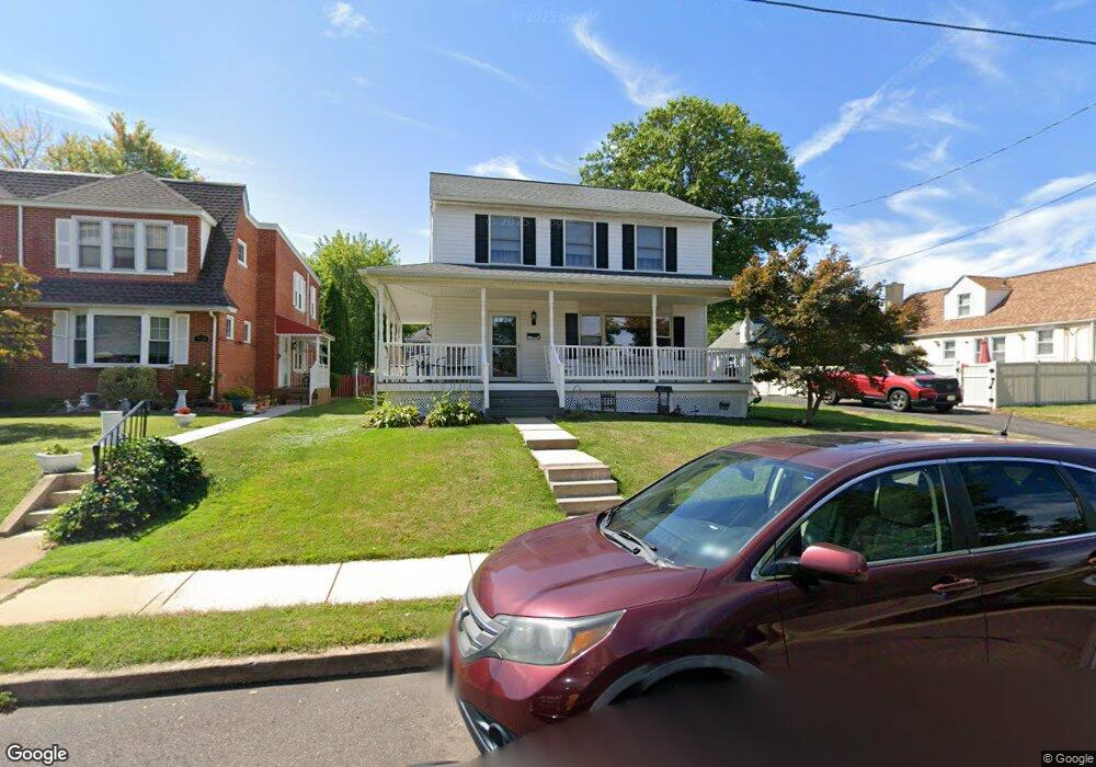
920 Derstine Ave Lansdale, PA 19446
Estimated Value: $424,000 - $444,000
3
Beds
2
Baths
1,456
Sq Ft
$301/Sq Ft
Est. Value
About This Home
This home is located at 920 Derstine Ave, Lansdale, PA 19446 and is currently estimated at $438,694, approximately $301 per square foot. 920 Derstine Ave is a home located in Montgomery County with nearby schools including York Avenue Elementary School, Penndale Middle School, and North Penn Senior High School.
Ownership History
Date
Name
Owned For
Owner Type
Purchase Details
Closed on
Aug 28, 1997
Sold by
Fitzgerald Denis J
Bought by
Peacock Raymond J and Peacock Carol F
Current Estimated Value
Purchase Details
Closed on
Feb 7, 1997
Sold by
Fitzgerald Denis J and Fitzgerald Dennis
Bought by
Fitzgerald Denis J
Purchase Details
Closed on
Dec 23, 1996
Sold by
Hangey Gaymore B and Hangey Robert W
Bought by
Fitzgerald Dennis
Create a Home Valuation Report for This Property
The Home Valuation Report is an in-depth analysis detailing your home's value as well as a comparison with similar homes in the area
Home Values in the Area
Average Home Value in this Area
Purchase History
| Date | Buyer | Sale Price | Title Company |
|---|---|---|---|
| Peacock Raymond J | $138,900 | -- | |
| Fitzgerald Denis J | -- | -- | |
| Fitzgerald Dennis | $29,000 | -- |
Source: Public Records
Tax History Compared to Growth
Tax History
| Year | Tax Paid | Tax Assessment Tax Assessment Total Assessment is a certain percentage of the fair market value that is determined by local assessors to be the total taxable value of land and additions on the property. | Land | Improvement |
|---|---|---|---|---|
| 2025 | $5,242 | $124,620 | $33,960 | $90,660 |
| 2024 | $5,242 | $124,620 | $33,960 | $90,660 |
| 2023 | $4,904 | $124,620 | $33,960 | $90,660 |
| 2022 | $4,748 | $124,620 | $33,960 | $90,660 |
| 2021 | $4,554 | $124,620 | $33,960 | $90,660 |
| 2020 | $4,417 | $124,620 | $33,960 | $90,660 |
| 2019 | $4,344 | $124,620 | $33,960 | $90,660 |
| 2018 | $1,165 | $124,620 | $33,960 | $90,660 |
| 2017 | $4,055 | $124,620 | $33,960 | $90,660 |
| 2016 | $4,006 | $124,620 | $33,960 | $90,660 |
| 2015 | $3,718 | $124,620 | $33,960 | $90,660 |
| 2014 | $3,718 | $124,620 | $33,960 | $90,660 |
Source: Public Records
Map
Nearby Homes
- 21 S Valley Forge Rd Unit 213
- 108 Allison Ct Unit 8
- 831 W Main St
- 13 W End Dr
- 1061 York Ave
- 204 N Valley Forge Rd Unit 7B
- 625 Derstine Ave
- 833 W 4th St
- 1025 Birch St
- 340 Central Dr
- 1028 Poplar St Unit 75
- 1035 Forest Ave
- 217 Cherry Ln
- 405 Derstine Ave
- 245 Cherry Ln
- 750 Annes Ct
- 129 W Fifth St
- 128 S Broad St
- 532 Green St
- 302 W 8th St Unit 21
- 916 Derstine Ave
- 914 Derstine Ave
- 43 S Valley Forge Rd
- 47 S Valley Forge Rd
- 912 Derstine Ave
- 910 Derstine Ave
- 906 Derstine Ave
- 925 Columbia Ave
- 923 Columbia Ave
- 933 Columbia Ave
- 921 Columbia Ave
- 919 Columbia Ave
- 99 S Valley Forge Rd
- 155 S Valley Forge Rd
- 917 Columbia Ave
- 904 Derstine Ave
- 915 Columbia Ave
- 913 Columbia Ave
- 902 Derstine Ave
- 911 Columbia Ave