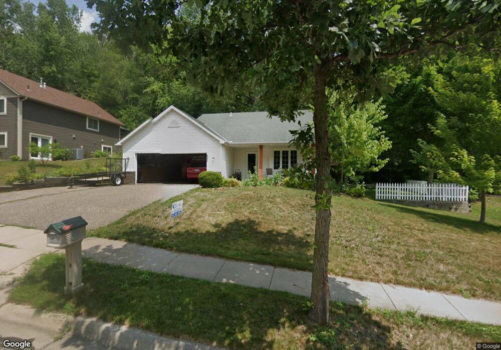
927 Aspen Ave Red Wing, MN 55066
Estimated Value: $334,525 - $383,000
4
Beds
2
Baths
1,965
Sq Ft
$180/Sq Ft
Est. Value
About This Home
This home is located at 927 Aspen Ave, Red Wing, MN 55066 and is currently estimated at $353,881, approximately $180 per square foot. 927 Aspen Ave is a home located in Goodhue County with nearby schools including Burnside Elementary School, Sunnyside Elementary School, and Twin Bluff Middle School.
Ownership History
Date
Name
Owned For
Owner Type
Purchase Details
Closed on
Sep 4, 2015
Sold by
Quast Mark A and Quast Misty L R
Bought by
Wendland Michael S and Wendland Jennifer M
Current Estimated Value
Purchase Details
Closed on
Sep 19, 2003
Sold by
Carrol Tracy L
Bought by
Quast Mark A and Quast Lee R
Purchase Details
Closed on
Jul 31, 2002
Sold by
Rapier Richard G and Rapier Shelley A
Bought by
Carroll Tracy
Purchase Details
Closed on
Sep 28, 2000
Sold by
Burkel Michael R and Burkel Krista L
Bought by
Rapier Richard G and Rapier Shelley A
Purchase Details
Closed on
Sep 6, 2000
Sold by
Rcc Construction Inc
Bought by
Burkel Michael R and Burkel Krista L
Purchase Details
Closed on
Aug 8, 1997
Sold by
Biermann Homes Inc
Bought by
Burkel Michael R and Burkel Krista L
Purchase Details
Closed on
Apr 17, 1997
Sold by
Charlson Arnold G and Charlson Janet B
Bought by
Biermann Homes Inc
Create a Home Valuation Report for This Property
The Home Valuation Report is an in-depth analysis detailing your home's value as well as a comparison with similar homes in the area
Home Values in the Area
Average Home Value in this Area
Purchase History
| Date | Buyer | Sale Price | Title Company |
|---|---|---|---|
| Wendland Michael S | $215,000 | Goodhue County Abstract | |
| Quast Mark A | $182,500 | -- | |
| Carroll Tracy | $167,000 | -- | |
| Rapier Richard G | $153,500 | -- | |
| Burkel Michael R | $21,500 | -- | |
| Burkel Michael R | $144,942 | -- | |
| Biermann Homes Inc | $23,000 | -- |
Source: Public Records
Tax History
| Year | Tax Paid | Tax Assessment Tax Assessment Total Assessment is a certain percentage of the fair market value that is determined by local assessors to be the total taxable value of land and additions on the property. | Land | Improvement |
|---|---|---|---|---|
| 2025 | $4,086 | $322,400 | $43,200 | $279,200 |
| 2024 | $4,086 | $317,200 | $43,200 | $274,000 |
| 2023 | $2,016 | $297,100 | $43,200 | $253,900 |
| 2022 | $3,556 | $295,200 | $43,200 | $252,000 |
| 2021 | $3,250 | $250,200 | $43,200 | $207,000 |
| 2020 | $3,200 | $233,700 | $43,200 | $190,500 |
| 2019 | $3,182 | $216,700 | $43,200 | $173,500 |
| 2018 | $2,538 | $217,900 | $41,600 | $176,300 |
| 2017 | $2,476 | $189,800 | $41,600 | $148,200 |
| 2016 | $2,262 | $187,700 | $41,600 | $146,100 |
| 2015 | $2,162 | $181,000 | $41,600 | $139,400 |
| 2014 | -- | $173,200 | $41,600 | $131,600 |
Source: Public Records
Map
Nearby Homes
- 912 Aurora Cir
- 853 Aurora Cir
- 4739 Big Sky Ct
- 1056 Birch Ave
- 980 Aurora Cir
- 921 Snowbird Dr
- 914 Snowbird Dr
- 910 Snowbird Dr
- 133 Kingswood Dr
- 135 Kingswood Dr
- 4958 Chalet Ct
- 237 Butternut Ave
- 5542 Cannon Dale Ct
- 3429 Helen Ln
- 186 Sargent Dr
- 210 Sargent Dr Unit 103
- 113 Burnside Ave S
- 1125 Hewitt Blvd
- 2820 N Service Dr
- 374 Westwood South St
Your Personal Tour Guide
Ask me questions while you tour the home.