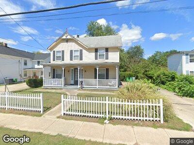
927 Montgomery St Laurel, MD 20707
Estimated Value: $446,119 - $576,000
--
Bed
2
Baths
2,118
Sq Ft
$242/Sq Ft
Est. Value
About This Home
This home is located at 927 Montgomery St, Laurel, MD 20707 and is currently estimated at $512,780, approximately $242 per square foot. 927 Montgomery St is a home located in Prince George's County with nearby schools including Scotchtown Hills Elementary School, Dwight D. Eisenhower Middle School, and Laurel High School.
Ownership History
Date
Name
Owned For
Owner Type
Purchase Details
Closed on
Jun 20, 2007
Sold by
Mcwilliams Carl
Bought by
Mcwilliams Living Trust and Rebecca Mcwilliams,Carl
Current Estimated Value
Purchase Details
Closed on
May 18, 2007
Sold by
Mcwilliams Carl
Bought by
Mcwilliams Living Trust and Rebecca Mcwilliams,Carl
Purchase Details
Closed on
Dec 26, 1985
Sold by
Schmidt William W
Bought by
Mcwilliams Carl and Rebecca Simmons
Create a Home Valuation Report for This Property
The Home Valuation Report is an in-depth analysis detailing your home's value as well as a comparison with similar homes in the area
Home Values in the Area
Average Home Value in this Area
Purchase History
| Date | Buyer | Sale Price | Title Company |
|---|---|---|---|
| Mcwilliams Living Trust | -- | -- | |
| Mcwilliams Living Trust | -- | -- | |
| Mcwilliams Carl | $105,000 | -- |
Source: Public Records
Mortgage History
| Date | Status | Borrower | Loan Amount |
|---|---|---|---|
| Open | Mcwilliams Carl | $253,400 | |
| Previous Owner | Mcwilliams Carl F | $50,000 | |
| Previous Owner | Mcwilliams Carl | $32,000 | |
| Previous Owner | Mcwilliams Carl | $120,260 |
Source: Public Records
Tax History Compared to Growth
Tax History
| Year | Tax Paid | Tax Assessment Tax Assessment Total Assessment is a certain percentage of the fair market value that is determined by local assessors to be the total taxable value of land and additions on the property. | Land | Improvement |
|---|---|---|---|---|
| 2024 | $5,807 | $390,000 | $0 | $0 |
| 2023 | $5,552 | $372,200 | $0 | $0 |
| 2022 | $5,256 | $354,400 | $102,100 | $252,300 |
| 2021 | $4,924 | $331,233 | $0 | $0 |
| 2020 | $4,679 | $308,067 | $0 | $0 |
| 2019 | $4,427 | $284,900 | $76,000 | $208,900 |
| 2018 | $4,220 | $268,067 | $0 | $0 |
| 2017 | $4,034 | $251,233 | $0 | $0 |
| 2016 | -- | $234,400 | $0 | $0 |
| 2015 | $3,763 | $234,400 | $0 | $0 |
| 2014 | $3,763 | $234,400 | $0 | $0 |
Source: Public Records
Map
Nearby Homes
- 305 9th St
- 916 Philip Powers Dr
- 1110 Montgomery St
- 407 Sandy Spring Rd
- 1106 Snowden Place
- 1125 Westview Terrace
- 926 West St
- 610 Main St Unit 511
- 610 Main St Unit 413
- 9201 Redbridge Ct
- 1007 7th St
- 9545 Bolton Farm Rd
- 9679 Baltimore Ave
- 9524 Bolton Farm Ln
- 9520 Bolton Farm Ln
- 9516 Bolton Farm Ln
- 9500 Bolton Farm Ln
- 9508 Bolton Farm Ln
- 9532 Bolton Farm Ln
- 9512 Bolton Farm Ln
- 927 Montgomery St
- 929 Montgomery St Unit B
- 929 Montgomery St
- 929 Montgomery St Unit C
- 210 10th St
- 216 10th Street B Unit B
- 923 Montgomery St
- 216 10th St
- 216 10th St Unit B
- 214 10th Street A Unit A
- 214 10th St
- 214 10th St Unit A
- 214 10th St Unit B
- 931 Montgomery St
- 206 10th St
- 921 Montgomery St
- 933 Montgomery St
- 919 Montgomery St
- 204 10th St
- 924 Montgomery St