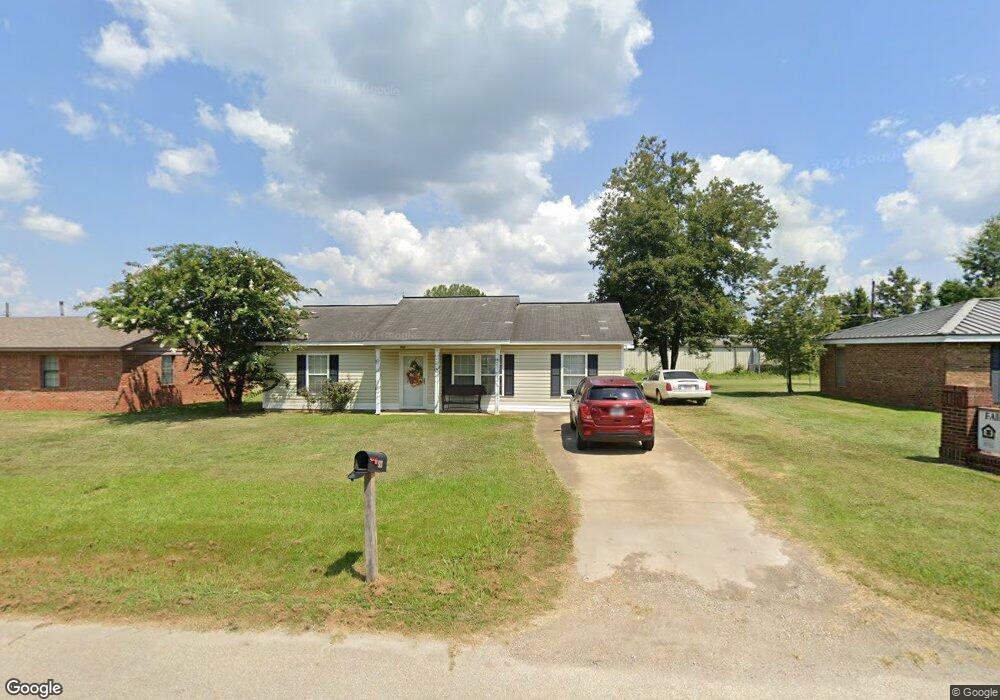
927 Reed St New Albany, MS 38652
Estimated Value: $120,470 - $223,000
3
Beds
2
Baths
1,056
Sq Ft
$150/Sq Ft
Est. Value
About This Home
This home is located at 927 Reed St, New Albany, MS 38652 and is currently estimated at $158,618, approximately $150 per square foot. 927 Reed St is a home located in Union County with nearby schools including New Albany Elementary School, New Albany/S.Tippah/Union County Alternative School, and New Albany Middle School.
Ownership History
Date
Name
Owned For
Owner Type
Purchase Details
Closed on
Aug 16, 2019
Sold by
Turner Larry Keith and Turner Marquita
Bought by
Spires Jimmy W
Current Estimated Value
Home Financials for this Owner
Home Financials are based on the most recent Mortgage that was taken out on this home.
Original Mortgage
$89,898
Outstanding Balance
$78,895
Interest Rate
3.8%
Mortgage Type
New Conventional
Estimated Equity
$79,723
Purchase Details
Closed on
Dec 18, 2007
Sold by
Good Neighbors Habitat For Humanity
Bought by
Turner Larry Keith and Turner Marquita
Create a Home Valuation Report for This Property
The Home Valuation Report is an in-depth analysis detailing your home's value as well as a comparison with similar homes in the area
Home Values in the Area
Average Home Value in this Area
Purchase History
| Date | Buyer | Sale Price | Title Company |
|---|---|---|---|
| Spires Jimmy W | -- | None Available | |
| Turner Larry Keith | -- | -- |
Source: Public Records
Mortgage History
| Date | Status | Borrower | Loan Amount |
|---|---|---|---|
| Open | Spires Jimmy W | $89,898 |
Source: Public Records
Tax History Compared to Growth
Tax History
| Year | Tax Paid | Tax Assessment Tax Assessment Total Assessment is a certain percentage of the fair market value that is determined by local assessors to be the total taxable value of land and additions on the property. | Land | Improvement |
|---|---|---|---|---|
| 2024 | $288 | $5,613 | $0 | $0 |
| 2023 | $289 | $5,613 | $0 | $0 |
| 2022 | $469 | $4,548 | $0 | $0 |
| 2021 | $506 | $5,066 | $0 | $0 |
| 2020 | $506 | $5,066 | $0 | $0 |
| 2019 | $506 | $5,066 | $0 | $0 |
| 2018 | $479 | $4,791 | $0 | $0 |
| 2017 | $459 | $4,780 | $0 | $0 |
| 2016 | $437 | $4,780 | $0 | $0 |
| 2015 | -- | $4,780 | $0 | $0 |
| 2014 | -- | $4,549 | $0 | $0 |
Source: Public Records
Map
Nearby Homes
- 931 Reed St
- 0 Lot 6 Sam T Barkley Dr
- Lot 48 Rolling Hills Dr
- Lot 49 Rolling Hills Dr
- 0 Lot 5 Sam T Barkley Dr
- 0 Lot 4 Sam T Barkley Dr
- 0 Lot 3 Sam T Barkley Dr
- 0 Lot 8 Sam T Barkley Dr
- 0 Lot 2 Sam Tbarkley Dr Unit 23-1317
- 1315 Moss Hill Dr
- 816 W Bankhead St
- 1329 Moss Hill Dr
- 0 Coulter Dr Denton Rd Unit 24-3689
- 1509 Allison Cir
- 0 Coulter Cove + - 52 Ac
- 102 Robbins Dr
- 301 Starlyn Ave
- 559 County Road 75
- 403 Bristol Ave
- 621 Glendale Rd
- 927 Reed St
- 929 Reed St
- 933 Reed St
- 932 Reed St
- 928 Reed St
- 307 N Glenfield Rd
- 213 N Glenfield Rd
- 1001 Rolling Hills Dr
- 211 N Glenfield Rd
- 1002 Rolling Hills Dr
- 204 N Glenfield Rd
- 204 N Glenfield Rd
- 1004 Rolling Hills Dr
- 1004 Rolling Hills Dr
- 118 Fairground Cir
- 101 Industrial Dr
- 120 Fairground Cir
- 1010 Rolling Hills Dr
- 114 N Glenfield Rd
- 117 N Glenfield Rd