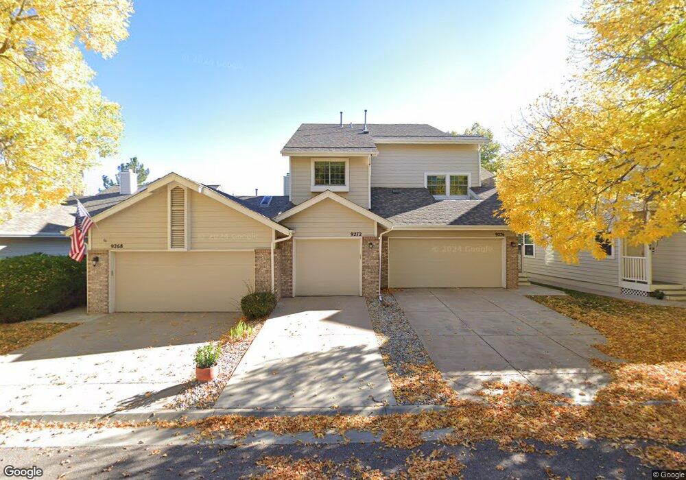
9272 Miles Dr Lone Tree, CO 80124
Estimated Value: $512,000 - $561,000
2
Beds
3
Baths
1,732
Sq Ft
$305/Sq Ft
Est. Value
About This Home
This home is located at 9272 Miles Dr, Lone Tree, CO 80124 and is currently estimated at $528,594, approximately $305 per square foot. 9272 Miles Dr is a home located in Douglas County with nearby schools including Eagle Ridge Elementary School, Cresthill Middle School, and Highlands Ranch High School.
Ownership History
Date
Name
Owned For
Owner Type
Purchase Details
Closed on
May 14, 2013
Sold by
Mcdonald Dale E and Mcdonald Darlene S
Bought by
Broadbend Julie A
Current Estimated Value
Purchase Details
Closed on
Aug 14, 1998
Sold by
Daniel Cordes
Bought by
Mcdonald Dale E and Mcdonald Darlene S
Home Financials for this Owner
Home Financials are based on the most recent Mortgage that was taken out on this home.
Original Mortgage
$104,800
Interest Rate
6.94%
Purchase Details
Closed on
Apr 29, 1994
Sold by
Thurston David S and Thurston Robin A
Bought by
Cordes Daniel
Purchase Details
Closed on
Mar 26, 1993
Sold by
Scott Catherine L
Bought by
Thurston David S and Thurston Robin A
Purchase Details
Closed on
Aug 11, 1989
Sold by
Hollenback & Co
Bought by
Scott Catherine L
Create a Home Valuation Report for This Property
The Home Valuation Report is an in-depth analysis detailing your home's value as well as a comparison with similar homes in the area
Home Values in the Area
Average Home Value in this Area
Purchase History
| Date | Buyer | Sale Price | Title Company |
|---|---|---|---|
| Broadbend Julie A | $239,000 | Fidelity National Title Insu | |
| Mcdonald Dale E | $149,800 | Stewart Title | |
| Cordes Daniel | $137,900 | -- | |
| Thurston David S | $123,900 | -- | |
| Scott Catherine L | $97,100 | -- |
Source: Public Records
Mortgage History
| Date | Status | Borrower | Loan Amount |
|---|---|---|---|
| Previous Owner | Mcdonald Dale E | $104,800 |
Source: Public Records
Tax History
| Year | Tax Paid | Tax Assessment Tax Assessment Total Assessment is a certain percentage of the fair market value that is determined by local assessors to be the total taxable value of land and additions on the property. | Land | Improvement |
|---|---|---|---|---|
| 2025 | $2,706 | $33,010 | -- | $33,010 |
| 2024 | $2,706 | $39,270 | -- | $39,270 |
| 2023 | $3,367 | $39,270 | $0 | $39,270 |
| 2022 | $2,523 | $27,750 | $0 | $27,750 |
| 2021 | $2,624 | $27,750 | $0 | $27,750 |
| 2020 | $2,311 | $25,040 | $1,430 | $23,610 |
| 2019 | $2,318 | $25,040 | $1,430 | $23,610 |
| 2018 | $2,074 | $23,960 | $1,440 | $22,520 |
| 2017 | $2,107 | $23,960 | $1,440 | $22,520 |
| 2016 | $1,952 | $21,750 | $1,590 | $20,160 |
| 2015 | $998 | $21,750 | $1,590 | $20,160 |
| 2014 | $1,965 | $20,080 | $1,590 | $18,490 |
Source: Public Records
Map
Nearby Homes
- 8046 Lodgepole Trail
- 8214 Lodgepole Trail
- 8159 Lodgepole Trail
- 8049 Sweet Water Rd
- 8666 Ainsdale Ct Unit 12B
- 8356 Green Island Cir
- 8822 Fiesta Terrace
- 8555 Green Island Cir
- 8860 Kachina Way
- 789 Mercury Cir
- 9570 Brook Hill Ln
- 357 Saturn Place
- 9345 Erminedale Dr
- 9594 Brook Hill Ln
- 7459 La Quinta Place
- 9835 Firestone Cir
- 9466 Wiltshire Dr
- 9873 Greensview Cir
- 130 Dianna Dr
- 13226 Canopus Dr
- 9276 Miles Dr
- 9268 Miles Dr Unit 3
- 9304 Miles Dr Unit 6
- 9264 Miles Dr Unit 4
- 9300 Miles Dr
- 9260 Miles Dr Unit 5
- 9308 Miles Dr Unit 45
- 9256 Miles Dr Unit 6
- 9312 Miles Dr Unit 4
- 8184 Lone Maple Ln
- 9252 Miles Dr Unit 7
- 9316 Miles Dr
- 8185 Lone Oak Ct
- 9278 Bauer Ct
- 8175 Lone Oak Ct
- 9320 Miles Dr
- 9290 Bauer Ct
- 9324 Miles Dr
- 9266 Bauer Ct
- 8174 Lone Maple Ln
Your Personal Tour Guide
Ask me questions while you tour the home.