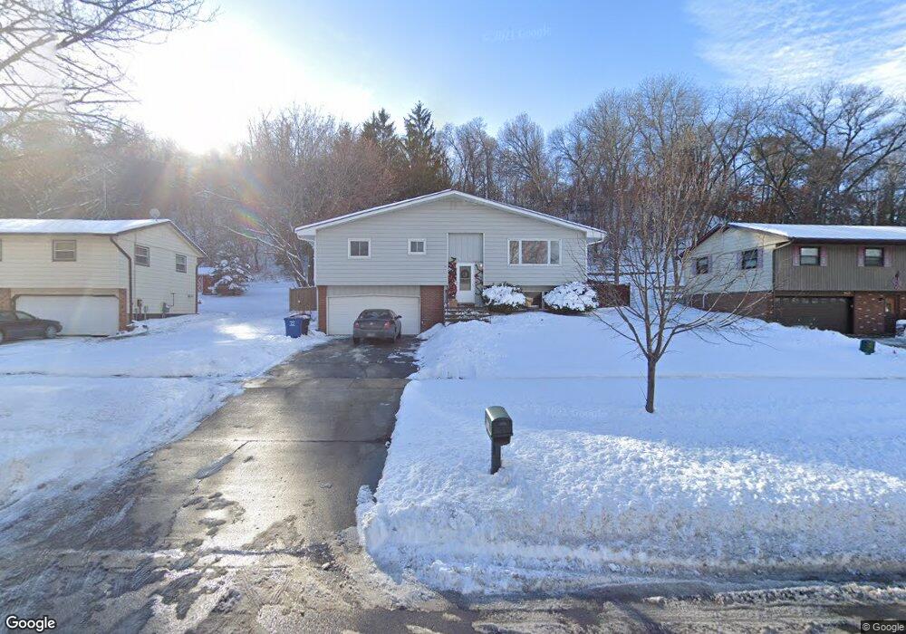
935 Pioneer Rd Red Wing, MN 55066
Estimated Value: $253,712 - $300,000
3
Beds
1
Bath
1,230
Sq Ft
$232/Sq Ft
Est. Value
About This Home
This home is located at 935 Pioneer Rd, Red Wing, MN 55066 and is currently estimated at $285,178, approximately $231 per square foot. 935 Pioneer Rd is a home located in Goodhue County with nearby schools including Sunnyside Elementary School, Burnside Elementary School, and Twin Bluff Middle School.
Ownership History
Date
Name
Owned For
Owner Type
Purchase Details
Closed on
Dec 1, 2022
Sold by
Hokanson Melroy J
Bought by
Hokanson Mark J and Hokanson Mitchell J
Current Estimated Value
Purchase Details
Closed on
Nov 30, 2016
Sold by
Bank Of New York Mellon
Bought by
Hokanson Melroy and Hokanson Leah Mae
Purchase Details
Closed on
Jul 21, 2005
Sold by
Mcmahon Ryan A and Mcmahon Carrie A
Bought by
Annis Michael and Annis Lisa A
Purchase Details
Closed on
Dec 22, 2000
Sold by
Books Effie A
Bought by
Mcmahon Ryan A and Mcmahon Carrie A
Create a Home Valuation Report for This Property
The Home Valuation Report is an in-depth analysis detailing your home's value as well as a comparison with similar homes in the area
Home Values in the Area
Average Home Value in this Area
Purchase History
| Date | Buyer | Sale Price | Title Company |
|---|---|---|---|
| Hokanson Mark J | -- | -- | |
| Hokanson Melroy | -- | None Available | |
| Annis Michael | $164,600 | -- | |
| Mcmahon Ryan A | $120,000 | -- |
Source: Public Records
Tax History Compared to Growth
Tax History
| Year | Tax Paid | Tax Assessment Tax Assessment Total Assessment is a certain percentage of the fair market value that is determined by local assessors to be the total taxable value of land and additions on the property. | Land | Improvement |
|---|---|---|---|---|
| 2025 | $3,172 | $241,100 | $55,700 | $185,400 |
| 2024 | -- | $234,200 | $55,700 | $178,500 |
| 2023 | $2,898 | $221,000 | $55,700 | $165,300 |
| 2022 | $2,760 | $213,700 | $49,700 | $164,000 |
| 2021 | $2,592 | $184,500 | $49,700 | $134,800 |
| 2020 | $2,606 | $175,600 | $49,700 | $125,900 |
| 2019 | $2,576 | $164,600 | $49,700 | $114,900 |
| 2018 | $2,156 | $164,600 | $47,700 | $116,900 |
| 2017 | $1,802 | $146,000 | $47,700 | $98,300 |
| 2016 | $1,652 | $145,000 | $47,700 | $97,300 |
| 2015 | $1,598 | $140,400 | $47,700 | $92,700 |
| 2014 | -- | $135,900 | $47,700 | $88,200 |
Source: Public Records
Map
Nearby Homes
- 1903 Lenore Ln
- 1927 Twin Bluff Rd
- 769 Pioneer Rd
- 1825 Twin Bluff Rd
- 1846 Twin Bluff Rd
- 732 Hi Park Ave
- 1838 Spruce Dr
- 672 Hi Park Ave
- 2345 S Oak Dr
- 676 Hi Park Ave
- 2351 Hallquist Ave
- 639 Hi Park Ave
- 1822 Bohmbach Dr
- 434 Fridell Crescent
- 1606 Reichert Ave
- 1940 Cherry St
- 611 Cherrywood Ct
- 2543 Sunny Meadow Ln
- 1224 Tee Up Ln
- 1164 Hawthorn St
- 943 Pioneer Rd
- 925 Pioneer Rd
- 917 Pioneer Rd
- 959 Pioneer Rd
- 909 Pioneer Rd
- 932 Pioneer Rd
- 940 Pioneer Rd
- 924 Pioneer Rd
- 948 Pioneer Rd
- 916 Pioneer Rd
- 967 Pioneer Rd
- 901 Pioneer Rd
- 956 Pioneer Rd
- 2126 Gernentz Fork
- 964 Pioneer Rd
- 975 Pioneer Rd
- 895 Pioneer Rd
- 972 Pioneer Rd
- 2237 Bevans Cir
- 2125 Gernentz Fork