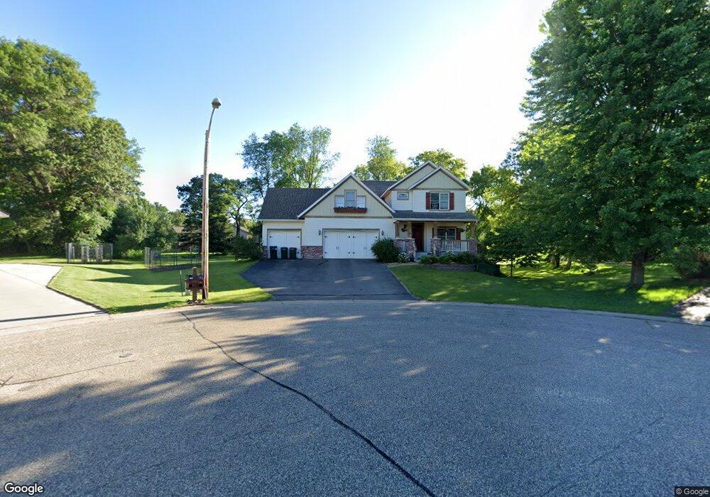
940 Crown Ct N Hudson, WI 54016
Estimated Value: $497,000 - $630,000
4
Beds
3
Baths
2,517
Sq Ft
$232/Sq Ft
Est. Value
About This Home
This home is located at 940 Crown Ct N, Hudson, WI 54016 and is currently estimated at $583,729, approximately $231 per square foot. 940 Crown Ct N is a home located in St. Croix County with nearby schools including North Hudson Elementary School, Hudson Middle School, and Hudson High School.
Ownership History
Date
Name
Owned For
Owner Type
Purchase Details
Closed on
Aug 25, 2008
Sold by
Mccoshen Kevin and Mccoshen Colleen
Bought by
Truso Paul C and Truso Sarah B
Current Estimated Value
Home Financials for this Owner
Home Financials are based on the most recent Mortgage that was taken out on this home.
Original Mortgage
$256,000
Outstanding Balance
$165,931
Interest Rate
6.42%
Mortgage Type
Purchase Money Mortgage
Estimated Equity
$417,798
Purchase Details
Closed on
Jun 1, 2006
Sold by
Symmetry Homes Inc
Bought by
Mccoslien Kevin and Mccoslien Colleen
Home Financials for this Owner
Home Financials are based on the most recent Mortgage that was taken out on this home.
Original Mortgage
$423,000
Interest Rate
8.99%
Mortgage Type
Adjustable Rate Mortgage/ARM
Create a Home Valuation Report for This Property
The Home Valuation Report is an in-depth analysis detailing your home's value as well as a comparison with similar homes in the area
Home Values in the Area
Average Home Value in this Area
Purchase History
| Date | Buyer | Sale Price | Title Company |
|---|---|---|---|
| Truso Paul C | $320,000 | Title One Premier Group | |
| Truso Paul C | $320,000 | Title One Premier Group | |
| Mccoslien Kevin | -- | None Available | |
| Mccoslien Kevin | -- | None Available |
Source: Public Records
Mortgage History
| Date | Status | Borrower | Loan Amount |
|---|---|---|---|
| Open | Truso Paul C | $256,000 | |
| Previous Owner | Mccoslien Kevin | $423,000 |
Source: Public Records
Tax History
| Year | Tax Paid | Tax Assessment Tax Assessment Total Assessment is a certain percentage of the fair market value that is determined by local assessors to be the total taxable value of land and additions on the property. | Land | Improvement |
|---|---|---|---|---|
| 2025 | $7,200 | $525,600 | $79,200 | $446,400 |
| 2024 | $69 | $525,600 | $79,200 | $446,400 |
| 2023 | $6,589 | $525,600 | $79,200 | $446,400 |
| 2022 | $7,583 | $525,600 | $79,200 | $446,400 |
| 2021 | $7,422 | $370,200 | $68,500 | $301,700 |
| 2020 | $7,170 | $370,200 | $68,500 | $301,700 |
| 2019 | $6,699 | $370,200 | $68,500 | $301,700 |
| 2018 | $6,647 | $370,200 | $68,500 | $301,700 |
| 2017 | $6,400 | $370,200 | $68,500 | $301,700 |
| 2016 | $6,400 | $370,200 | $68,500 | $301,700 |
| 2015 | $5,880 | $370,200 | $68,500 | $301,700 |
| 2014 | $5,832 | $370,200 | $68,500 | $301,700 |
| 2013 | $6,166 | $394,900 | $74,900 | $320,000 |
Source: Public Records
Map
Nearby Homes
- 241 Starrwood
- 811 Fox Tree Ln N
- 1029 Sommers St N
- 1031 Sommers St N
- 1110 Partridge Ln N
- 641 8th St N
- 1264 10th St N
- 214 Galahad Place N
- 612 4th St N Unit 15
- 1143 Sommers St N
- 1026 Monroe St N
- 1075 Autumn Oak Ln
- 1084 Autumn Oak Ln
- 403 7th St N
- 709 Saint Croix St N
- 418 4th St N
- 888 Bluebird Ct N
- 322 5th St N
- 312 Meadow Dr N
- 1205 Riverside Dr N
- 935 Crown Ct
- 930 Crown Ct
- 930 Crown Ct N
- 940 Crown Ct
- 935 Crown Ct
- 920 Crown Ct
- 925 Crown Ct
- 915 Crown Ct N
- 915 Crown Ct
- 937 937 10th-Street-n
- 937 10th St N
- 947 10th St N
- 927 10th St N
- 930 Keystone Ct N Unit 6
- 940 Keystone Ct N Unit 5
- 950 Keystone Ct N Unit 4
- 960 Keystone Ct N Unit 3
- 980 Keystone Ct N Unit 1
- 1000 10th St N Unit 22
- 1004 10th St N Unit 21
Your Personal Tour Guide
Ask me questions while you tour the home.