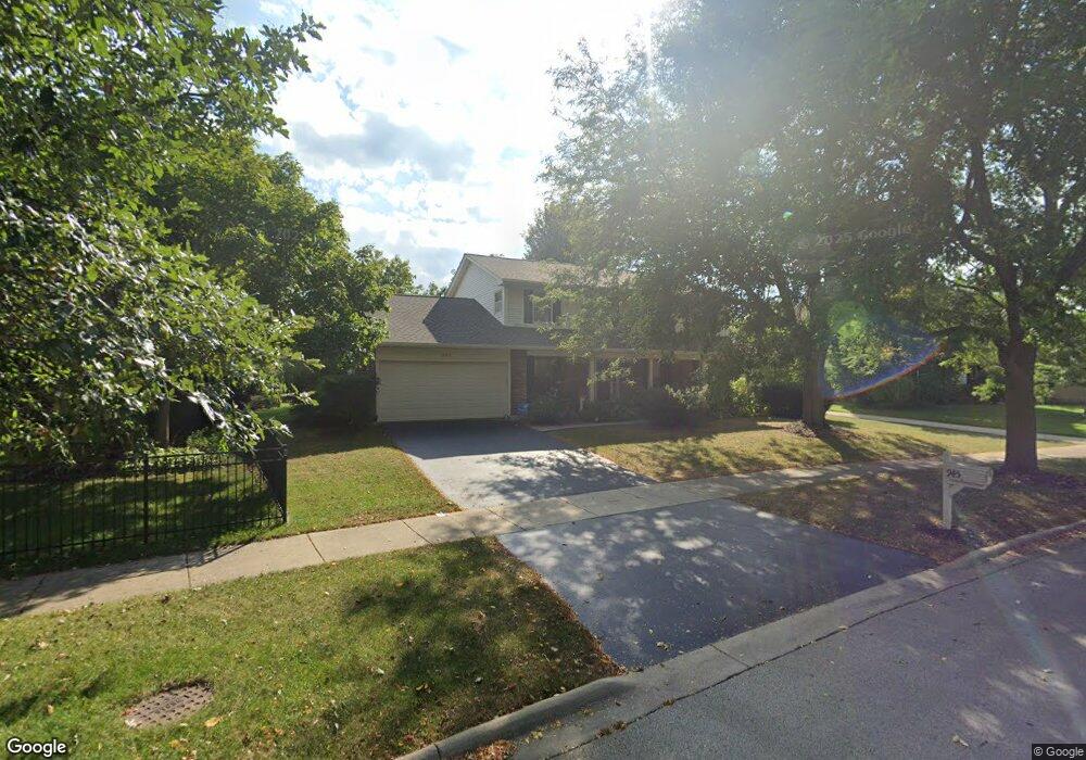
945 Appomattox Cir Naperville, IL 60540
Hobson West NeighborhoodEstimated Value: $697,826 - $811,000
4
Beds
3
Baths
2,871
Sq Ft
$263/Sq Ft
Est. Value
About This Home
This home is located at 945 Appomattox Cir, Naperville, IL 60540 and is currently estimated at $754,707, approximately $262 per square foot. 945 Appomattox Cir is a home located in DuPage County with nearby schools including Elmwood Elementary School, Lincoln Jr. High School, and Naperville Central High School.
Ownership History
Date
Name
Owned For
Owner Type
Purchase Details
Closed on
Aug 31, 1994
Sold by
Campbell Willis R and Campbell Barbara L
Bought by
Parker Michael and Parker Sally
Current Estimated Value
Home Financials for this Owner
Home Financials are based on the most recent Mortgage that was taken out on this home.
Original Mortgage
$125,000
Interest Rate
8.59%
Create a Home Valuation Report for This Property
The Home Valuation Report is an in-depth analysis detailing your home's value as well as a comparison with similar homes in the area
Home Values in the Area
Average Home Value in this Area
Purchase History
| Date | Buyer | Sale Price | Title Company |
|---|---|---|---|
| Parker Michael | $225,000 | Attorneys Title Guaranty Fun |
Source: Public Records
Mortgage History
| Date | Status | Borrower | Loan Amount |
|---|---|---|---|
| Closed | Parker Michael | $125,000 |
Source: Public Records
Tax History
| Year | Tax Paid | Tax Assessment Tax Assessment Total Assessment is a certain percentage of the fair market value that is determined by local assessors to be the total taxable value of land and additions on the property. | Land | Improvement |
|---|---|---|---|---|
| 2024 | $12,295 | $216,482 | $76,579 | $139,903 |
| 2023 | $11,583 | $194,520 | $68,810 | $125,710 |
| 2022 | $11,425 | $182,820 | $64,210 | $118,610 |
| 2021 | $11,024 | $176,300 | $61,920 | $114,380 |
| 2020 | $10,989 | $176,300 | $61,920 | $114,380 |
| 2019 | $10,598 | $167,680 | $58,890 | $108,790 |
| 2018 | $10,312 | $163,540 | $56,670 | $106,870 |
| 2017 | $10,102 | $158,000 | $54,750 | $103,250 |
| 2016 | $9,859 | $151,630 | $52,540 | $99,090 |
| 2015 | $9,874 | $143,970 | $49,890 | $94,080 |
| 2014 | $9,645 | $136,670 | $47,020 | $89,650 |
| 2013 | $9,579 | $137,620 | $47,350 | $90,270 |
Source: Public Records
Map
Nearby Homes
- 1033 Emerald Dr
- 316 Hemlock Ln
- 840 Mobile Ct
- 845 Tulip Ln
- 817 Cardiff Rd
- 534 Grimes Ave
- 1161 Banyon Ct
- 1447 Baldwin Ct
- 316 Sycamore Dr Unit 11
- 313 W Gartner Rd
- 854 Raintree Dr
- 7S410 Arbor Dr
- 816 S River Rd
- 308 Tamarack Ave
- 731 S River Rd
- 1095 Devonshire Ave
- 661 Willow Rd
- 289 Winding Creek Dr
- 1210 Lawnmeadow Ln
- 7S146 Wild Cherry Rd
- 1007 Williamsburg Dr
- 931 Appomattox Cir
- 1011 Williamsburg Dr
- 938 Appomattox Cir Unit 3
- 929 Appomattox Cir
- 1015 Kennesaw Ct
- 934 Appomattox Cir
- 1015 Williamsburg Dr
- 941 Williamsburg Dr
- 1016 Kennesaw Ct
- 930 Appomattox Cir
- 1019 Kennesaw Ct
- 1019 Williamsburg Dr
- 937 Williamsburg Dr
- 948 Merrimac Cir
- 944 Merrimac Cir
- 1008 Williamsburg Dr
- 630 Vicksburg Ct
- 1020 Kennesaw Ct
- 1023 Williamsburg Dr
Your Personal Tour Guide
Ask me questions while you tour the home.