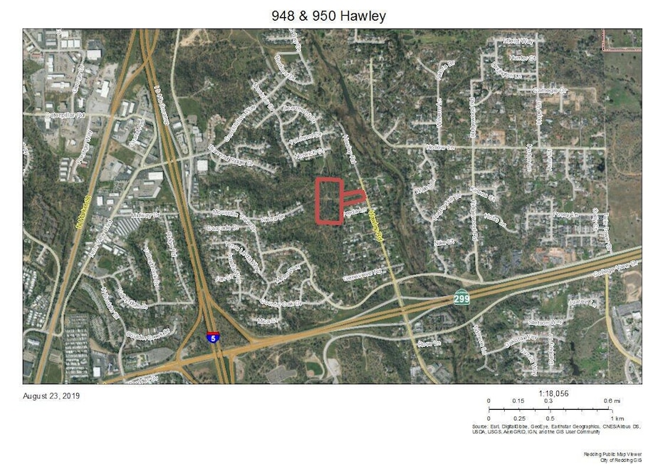
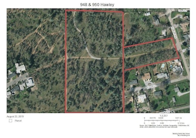
948 & 950 Hawley Redding, CA 96003
Midway NeighborhoodAbout This Lot
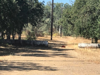
2 parcels totaling over 12 acres of land in North East Redding. This acreage is mostly flat and conveniently located close to Churn Creek Road, I-5 and HWY299. Shopping and area colleges are close by. Zoned residential. There was a tentative map at one point but it now expired. There are other connecting parcels listed for a larger subdivision opportunity. If you are looking for rural feeling acreage in city limits or a subdivision development opportunity, this could be the one!

Property Details
Property Type
- Land
Lot Details
- 12.1 Acre Lot
- Level Lot
Listing and Financial Details
- Assessor Parcel Number 116-280-001-000
Map
Home Values in the Area
Average Home Value in this Area
Tax History
| Year | Tax Paid | Tax Assessment Tax Assessment Total Assessment is a certain percentage of the fair market value that is determined by local assessors to be the total taxable value of land and additions on the property. | Land | Improvement |
|---|---|---|---|---|
| 2025 | $1,328 | $102,000 | $102,000 | -- |
| 2024 | $1,303 | $122,131 | $122,131 | -- |
| 2023 | $1,303 | $119,737 | $119,737 | $0 |
| 2022 | $1,268 | $117,390 | $117,390 | $0 |
| 2021 | $1,252 | $115,089 | $115,089 | $0 |
| 2020 | $1,247 | $113,909 | $113,909 | $0 |
| 2019 | $1,209 | $111,676 | $111,676 | $0 |
| 2018 | $1,209 | $109,487 | $109,487 | $0 |
| 2017 | $1,189 | $107,341 | $107,341 | $0 |
| 2016 | $1,137 | $105,237 | $105,237 | $0 |
| 2015 | $1,119 | $103,657 | $103,657 | $0 |
| 2014 | -- | $101,627 | $101,627 | $0 |
Property History
| Date | Event | Price | List to Sale | Price per Sq Ft |
|---|---|---|---|---|
| 01/19/2026 01/19/26 | Pending | -- | -- | -- |
| 09/09/2025 09/09/25 | Price Changed | $300,000 | 0.0% | -- |
| 09/09/2025 09/09/25 | For Sale | $300,000 | -7.7% | -- |
| 09/05/2025 09/05/25 | Off Market | $325,000 | -- | -- |
| 02/28/2025 02/28/25 | Price Changed | $325,000 | -16.7% | -- |
| 02/29/2024 02/29/24 | Price Changed | $390,000 | -1.5% | -- |
| 01/09/2024 01/09/24 | For Sale | $396,000 | -- | -- |
Source: Shasta Association of REALTORS®
MLS Number: 24-66
APN: 116-280-001-000
Disclaimer: Certain information contained herein is derived from information provided by parties other than Homes.com. All information provided is deemed reliable, but is not guaranteed to be accurate and should be independently verified.
![]() IDX information is provided exclusively for personal, non-commercial use, and may not be used for any purpose other than to identify prospective properties consumers may be interested in purchasing. Information is deemed reliable but not guaranteed.
IDX information is provided exclusively for personal, non-commercial use, and may not be used for any purpose other than to identify prospective properties consumers may be interested in purchasing. Information is deemed reliable but not guaranteed.
- 5961 Sierra Dr
- 5976 Sierra Dr
- 5663 Terra Linda Way
- 5890 Shadow Glen Dr
- 1050 Hillsdale Ct
- 5808 Constitution Way
- 5536 Trish Ct
- 19219 Nike Ct
- 6040 Constitution Way
- 5513 Diamond Ridge Dr
- 19226 Snowburst Ct
- 11632 Ridgewood Rd
- 846 Ridge Rd
- 61 Tidmore Ln
- 1102 Hope Ln
- 1672 Saint Andrews Dr
- 19424 Posey Ln
- 581 N Boulder Dr
- 6050 Gleneagles Ct
- 6260 Carmel Dr
Ask me questions while you tour the home.