
Seller's Agent in 2025
Amy Patterson
Crye-Leike Of MS-OB
(901) 604-0153
6 in this area
132 Total Sales

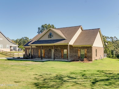
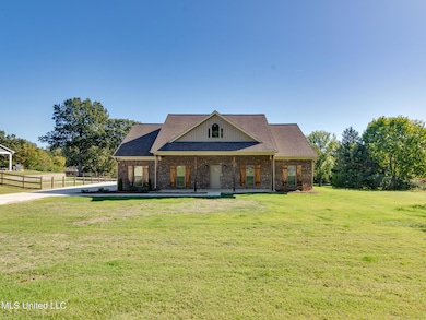
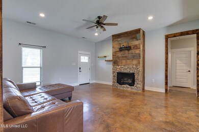
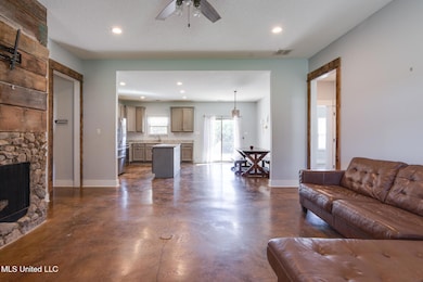
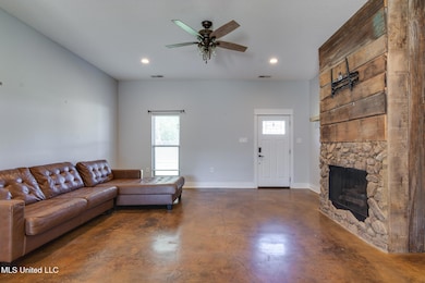
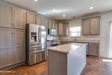
This Lewisburg beauty is the perfect blend of comfort, character, and countryside charm! Nestled on a peaceful 1-acre lot in the highly sought-after **Lewisburg School District**, this 3-bedroom, 2-bath home feels like the perfect mix of country quiet and modern comfort. Built in 2017 it's the kind of place that instantly feels like home. From the moment you step inside, you'll notice the **durable, polished concrete floors** that stretch throughout—stylish, low-maintenance, and perfect for busy days or barefoot mornings. The heart of the home is the open kitchen, featuring granite countertops, a large island for gathering, and even the **refrigerator included**. Mealtime feels special in the custom eat-in nook, complete with a custom bench table—a cozy spot for coffee, homework, or catching up after a long day. The primary suite is a true retreat with warm wood-plank cabinetry in the en suite, granite counters, and a luxurious bath featuring a huge tiled shower and separate tub. Every detail was thoughtfully chosen to create a space that's as functional as it is beautiful. You'll also love the extras—washer and dryer stay, an extra-long concrete driveway with plenty of parking, and a large covered patio out back, perfect for grilling, entertaining, or just watching the sunset over your own slice of Mississippi sky. Homes like this don't come around often—especially in Lewisburg. Come see why this one stands out from the rest.
Last Agent to Sell the Property
Crye-Leike Of MS-OB License #B22197 Listed on: 10/23/2025
| Date | Type | Sale Price | Title Company |
|---|---|---|---|
| Warranty Deed | -- | Realty Title | |
| Warranty Deed | -- | Select Title & Escrow | |
| Warranty Deed | -- | None Available |
| Date | Status | Loan Amount | Loan Type |
|---|---|---|---|
| Open | $300,000 | New Conventional | |
| Previous Owner | $291,000 | New Conventional | |
| Previous Owner | $201,286 | FHA |
| Date | Event | Price | List to Sale | Price per Sq Ft |
|---|---|---|---|---|
| 11/12/2025 11/12/25 | Sold | -- | -- | -- |
| 10/25/2025 10/25/25 | Pending | -- | -- | -- |
| 10/23/2025 10/23/25 | For Sale | $320,000 | -- | $188 / Sq Ft |
| Year | Tax Paid | Tax Assessment Tax Assessment Total Assessment is a certain percentage of the fair market value that is determined by local assessors to be the total taxable value of land and additions on the property. | Land | Improvement |
|---|---|---|---|---|
| 2025 | $1,539 | $18,654 | $1,000 | $17,654 |
| 2024 | $1,325 | $13,254 | $1,000 | $12,254 |
| 2023 | $1,325 | $13,254 | $0 | $0 |
| 2022 | $1,025 | $13,254 | $1,000 | $12,254 |
| 2021 | $1,025 | $13,254 | $1,000 | $12,254 |
| 2020 | $927 | $12,275 | $1,000 | $11,275 |
| 2019 | $927 | $12,275 | $1,000 | $11,275 |
| 2017 | $151 | $1,500 | $1,500 | $0 |
Seller's Agent in 2025
Amy Patterson
Crye-Leike Of MS-OB
(901) 604-0153
6 in this area
132 Total Sales
M
Buyer's Agent in 2025
McKeever Heun
Anton Realty & Appraisals
(901) 210-9669
9 in this area
56 Total Sales
Source: MLS United
MLS Number: 4129468
APN: 3071020000003702
Disclaimer: Certain information contained herein is derived from information provided by parties other than Homes.com. All information provided is deemed reliable, but is not guaranteed to be accurate and should be independently verified.
![]() Information is deemed to be reliable but not guaranteed. Copyright 2026 MLS United, LLC.
Information is deemed to be reliable but not guaranteed. Copyright 2026 MLS United, LLC.