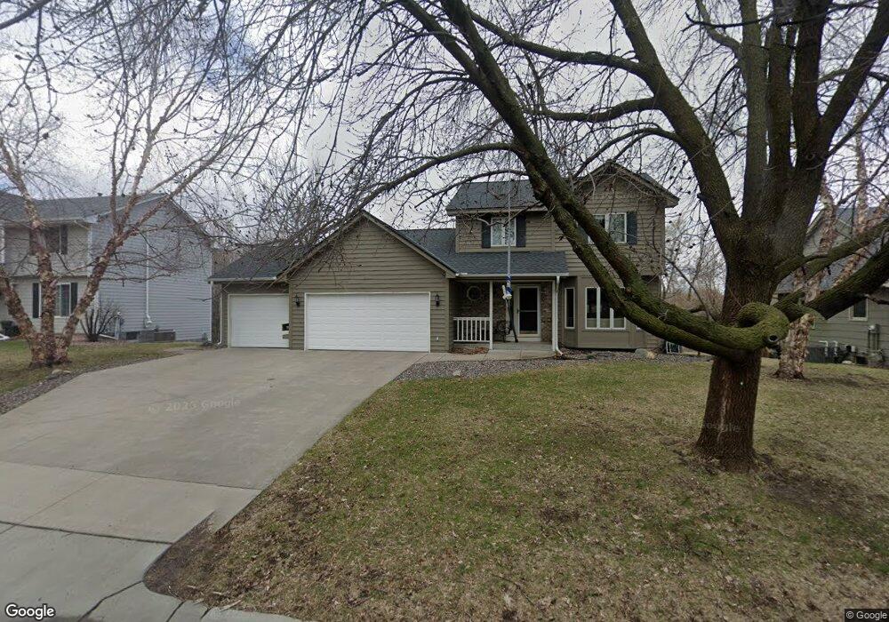
9529 Teakwood Ln N Maple Grove, MN 55369
Estimated Value: $522,000 - $554,000
4
Beds
3
Baths
1,666
Sq Ft
$322/Sq Ft
Est. Value
About This Home
This home is located at 9529 Teakwood Ln N, Maple Grove, MN 55369 and is currently estimated at $536,991, approximately $322 per square foot. 9529 Teakwood Ln N is a home located in Hennepin County with nearby schools including Fernbrook Elementary School, Osseo Middle School, and Maple Grove Senior High School.
Ownership History
Date
Name
Owned For
Owner Type
Purchase Details
Closed on
Aug 26, 2009
Sold by
Bertrand William
Bought by
White Stephen M and White Caroline L
Current Estimated Value
Purchase Details
Closed on
Jul 7, 2008
Sold by
Poppie David A and Poppie Kristine M
Bought by
Bertrand William G
Create a Home Valuation Report for This Property
The Home Valuation Report is an in-depth analysis detailing your home's value as well as a comparison with similar homes in the area
Home Values in the Area
Average Home Value in this Area
Purchase History
| Date | Buyer | Sale Price | Title Company |
|---|---|---|---|
| White Stephen M | $345,000 | -- | |
| Bertrand William G | $322,600 | -- |
Source: Public Records
Tax History Compared to Growth
Tax History
| Year | Tax Paid | Tax Assessment Tax Assessment Total Assessment is a certain percentage of the fair market value that is determined by local assessors to be the total taxable value of land and additions on the property. | Land | Improvement |
|---|---|---|---|---|
| 2024 | $6,321 | $490,000 | $143,800 | $346,200 |
| 2023 | $5,879 | $468,400 | $127,900 | $340,500 |
| 2022 | $4,917 | $460,600 | $113,200 | $347,400 |
| 2021 | $4,779 | $376,200 | $84,500 | $291,700 |
| 2020 | $4,972 | $359,900 | $74,500 | $285,400 |
| 2019 | $5,096 | $357,000 | $83,800 | $273,200 |
| 2018 | $4,638 | $346,900 | $87,900 | $259,000 |
| 2017 | $4,665 | $325,000 | $87,000 | $238,000 |
| 2016 | $4,483 | $309,400 | $80,000 | $229,400 |
| 2015 | $4,450 | $299,700 | $78,000 | $221,700 |
| 2014 | -- | $266,700 | $78,000 | $188,700 |
Source: Public Records
Map
Nearby Homes
- 12795 95th Ave N
- 13744 94th Ave N
- 9828 Zinnia Ln N
- 9323 Magnolia Ln N
- 13885 93rd Place N
- 9061 Underwood Ln N
- 12599 91st Place N
- 9323 Kirkwood Ln N
- 13391 Territorial Cir N
- 9421 Dallas Ln N
- 9311 Kirkwood Ln N
- 13434 Territorial Cir N
- 13485 Territorial Cir N
- 8949 Rosewood Ln N
- 9132 Kirkwood Ln N
- 13590 89th Ave N
- 14402 91st Place N
- 9201 Forestview Ln N
- 14661 94th Place N
- 14624 92nd Place N
- 9517 Teakwood Ln N
- 9541 Teakwood Ln N
- 9505 Teakwood Ln N
- 9514 Teakwood Ln N
- 9563 Teakwood Ln N
- 9501 Teakwood Ln N
- 9502 Teakwood Ln N
- 9526 Teakwood Ln N
- 9538 Teakwood Ln N
- 9550 Teakwood Ln N
- 9575 Teakwood Ln N
- 9562 Teakwood Ln N
- 9499 Teakwood Ln N
- 9574 Teakwood Ln N
- 9498 Teakwood Ln N
- 9587 Teakwood Ln N
- 9487 Teakwood Ln N
- 9486 Teakwood Ln N
- 9599 Teakwood Ln N
- 13025 96th Ave N