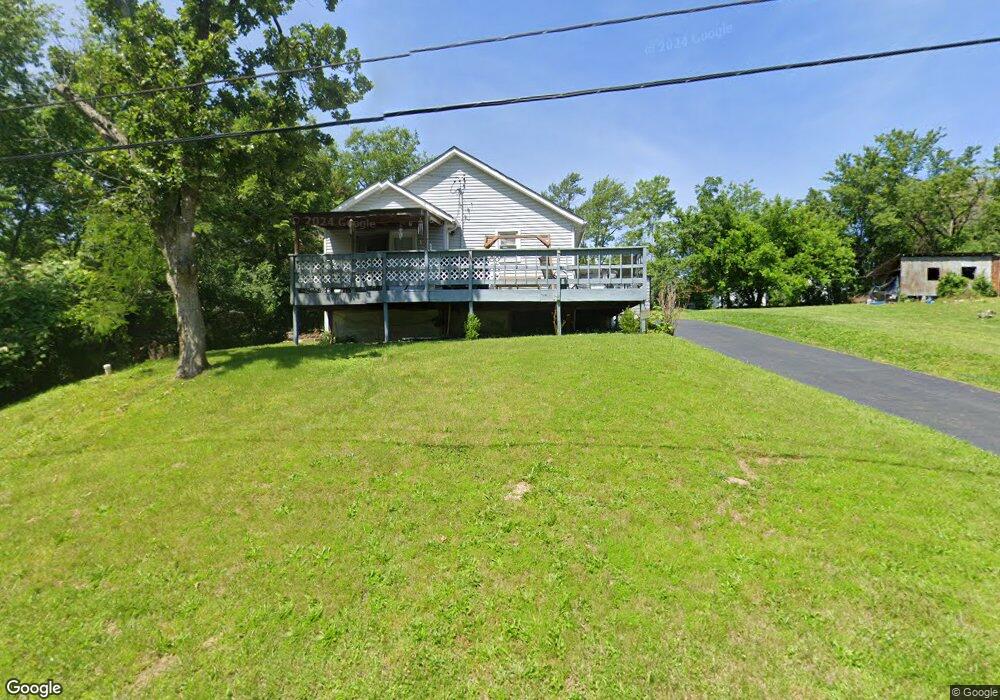
955 S Lay Ave Saint Clair, MO 63077
Estimated Value: $154,000 - $167,000
2
Beds
1
Bath
1,158
Sq Ft
$137/Sq Ft
Est. Value
About This Home
This home is located at 955 S Lay Ave, Saint Clair, MO 63077 and is currently estimated at $158,627, approximately $136 per square foot. 955 S Lay Ave is a home located in Franklin County with nearby schools including St. Clair Elementary School, Edgar Murray Elementary School, and St. Clair Junior High School.
Ownership History
Date
Name
Owned For
Owner Type
Purchase Details
Closed on
May 11, 2021
Sold by
Franklin Financial Corp
Bought by
Gooch Michael S and Gooch Nacole D
Current Estimated Value
Home Financials for this Owner
Home Financials are based on the most recent Mortgage that was taken out on this home.
Original Mortgage
$71,393
Outstanding Balance
$64,319
Interest Rate
3%
Mortgage Type
New Conventional
Estimated Equity
$94,308
Purchase Details
Closed on
Mar 7, 2011
Sold by
Marnin James Patrick and Marnin Carolyn Jean
Bought by
Franklin Financial Corp
Create a Home Valuation Report for This Property
The Home Valuation Report is an in-depth analysis detailing your home's value as well as a comparison with similar homes in the area
Home Values in the Area
Average Home Value in this Area
Purchase History
| Date | Buyer | Sale Price | Title Company |
|---|---|---|---|
| Gooch Michael S | -- | None Available | |
| Franklin Financial Corp | $34,489 | None Available |
Source: Public Records
Mortgage History
| Date | Status | Borrower | Loan Amount |
|---|---|---|---|
| Open | Gooch Michael S | $71,393 |
Source: Public Records
Tax History
| Year | Tax Paid | Tax Assessment Tax Assessment Total Assessment is a certain percentage of the fair market value that is determined by local assessors to be the total taxable value of land and additions on the property. | Land | Improvement |
|---|---|---|---|---|
| 2025 | $1,224 | $18,163 | $0 | $0 |
| 2024 | $1,224 | $15,138 | $0 | $0 |
| 2023 | $929 | $15,138 | $0 | $0 |
| 2022 | $857 | $13,903 | $0 | $0 |
| 2021 | $856 | $13,903 | $0 | $0 |
| 2020 | $827 | $12,881 | $0 | $0 |
| 2019 | $820 | $12,881 | $0 | $0 |
| 2018 | $814 | $12,628 | $0 | $0 |
| 2017 | $812 | $12,628 | $0 | $0 |
| 2016 | $868 | $13,486 | $0 | $0 |
| 2015 | $805 | $13,486 | $0 | $0 |
| 2014 | $806 | $13,513 | $0 | $0 |
Source: Public Records
Map
Nearby Homes
- 45 E Oak St
- 315 W Oak St
- 830 Walton St
- 330 Young St
- 235 E Oak St
- 208 Mosley Ave
- 5 Lots Mosley Ave
- 325 Iris Ct
- 0 Crescent Lake Rd Unit MIS25079528
- 347 Roller Rd
- 0 Oak Ridge Dr Unit MIS25078521
- 390 Highway Dr
- 605 N Main St
- 322 Cart Path Ln
- 445 Lakeshore Dr
- 555 Mulligan Ct
- 614 T-Box Dr
- 0 Gravois Rd Unit 11555468
- 440 Lake Shore Dr
- 111 Wrenwood Dr
- 935 S Lay Ave
- 975 S Lay Ave
- 925 S Lay Ave
- 1050 Hamilton St
- 1070 Hamilton St
- 1060 Hamilton St
- 1080 Hamilton St
- 1090 Hamilton St
- 985 S Lay Ave
- 1040 Hamilton St
- 1096 Hamilton St
- 35 E Lewis St
- 10 E Gravois Ave
- 1065 Hamilton St
- 1055 Hamilton St
- 1135 S Lay Ave
- 40 W Springfield Rd
- 25 E Lewis St
- 1075 Hamilton St
- 1085 Hamilton St
Your Personal Tour Guide
Ask me questions while you tour the home.