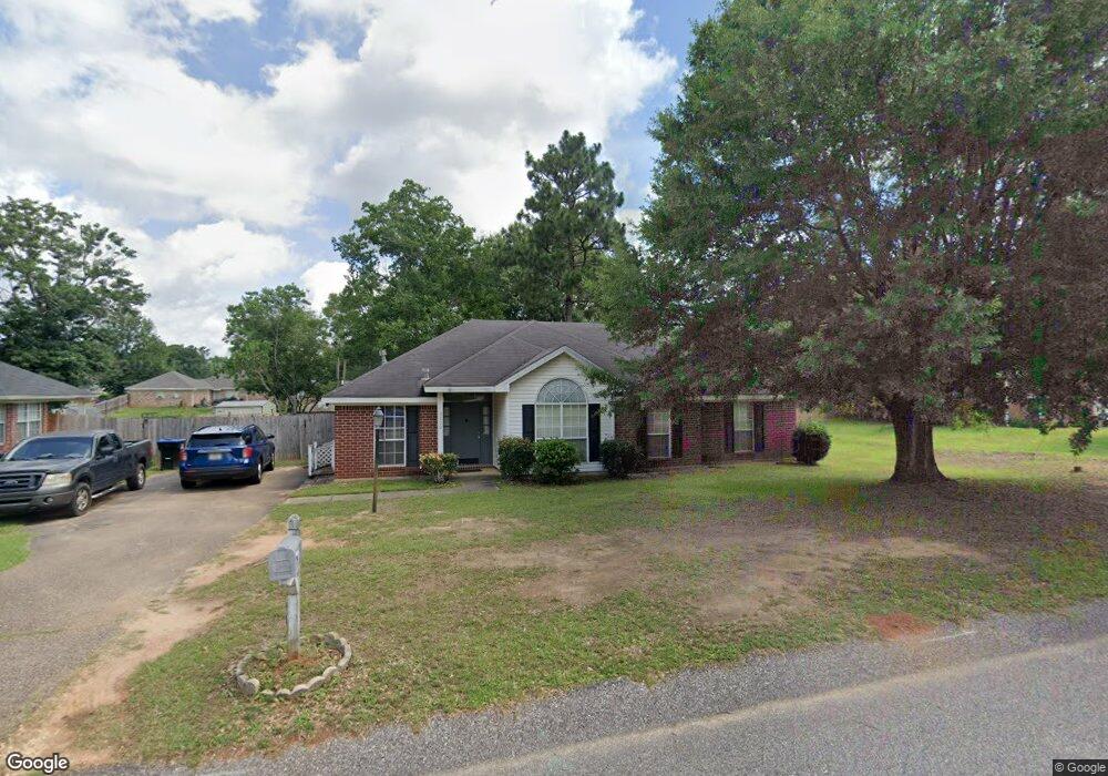
9550 Oak Forrest Dr Mobile, AL 36695
Baker NeighborhoodEstimated Value: $202,388 - $251,000
4
Beds
2
Baths
1,579
Sq Ft
$144/Sq Ft
Est. Value
About This Home
This home is located at 9550 Oak Forrest Dr, Mobile, AL 36695 and is currently estimated at $227,347, approximately $143 per square foot. 9550 Oak Forrest Dr is a home located in Mobile County with nearby schools including Elsie Collier Elementary School, Bernice J Causey Middle School, and Baker High School.
Ownership History
Date
Name
Owned For
Owner Type
Purchase Details
Closed on
Jul 18, 2000
Sold by
Robert Holding Company Inc
Bought by
Givens Stanley D and Givens Annette H
Current Estimated Value
Home Financials for this Owner
Home Financials are based on the most recent Mortgage that was taken out on this home.
Original Mortgage
$113,000
Outstanding Balance
$40,636
Interest Rate
8.3%
Estimated Equity
$186,711
Purchase Details
Closed on
May 18, 2000
Sold by
Myers Todd R
Bought by
Roberts Holding Company Inc
Create a Home Valuation Report for This Property
The Home Valuation Report is an in-depth analysis detailing your home's value as well as a comparison with similar homes in the area
Home Values in the Area
Average Home Value in this Area
Purchase History
| Date | Buyer | Sale Price | Title Company |
|---|---|---|---|
| Givens Stanley D | -- | -- | |
| Roberts Holding Company Inc | -- | -- |
Source: Public Records
Mortgage History
| Date | Status | Borrower | Loan Amount |
|---|---|---|---|
| Open | Givens Stanley D | $113,000 |
Source: Public Records
Tax History Compared to Growth
Tax History
| Year | Tax Paid | Tax Assessment Tax Assessment Total Assessment is a certain percentage of the fair market value that is determined by local assessors to be the total taxable value of land and additions on the property. | Land | Improvement |
|---|---|---|---|---|
| 2024 | $770 | $15,810 | $4,000 | $11,810 |
| 2023 | $770 | $15,410 | $4,000 | $11,410 |
| 2022 | $674 | $13,830 | $4,000 | $9,830 |
| 2021 | $664 | $13,610 | $4,000 | $9,610 |
| 2020 | $619 | $14,120 | $3,200 | $10,920 |
| 2019 | $612 | $14,000 | $0 | $0 |
| 2018 | $624 | $14,240 | $0 | $0 |
| 2017 | $602 | $12,360 | $0 | $0 |
| 2016 | $538 | $12,480 | $0 | $0 |
| 2013 | $621 | $13,220 | $0 | $0 |
Source: Public Records
Map
Nearby Homes
- 1120 Colonial Hills Dr
- 9665 Oak Forrest Dr
- 9556 Bridgeton Ct
- 9410 Ashwood Ct
- 9510 Gaslight Ct
- 960 Abilene Dr W
- 9601 Royal Woods Dr S
- 1261 Comstock Ct
- 1081 Hillside Ct
- 811 Royal Woods Dr W
- 1100 Wellington Ct S
- 9751 Pine Knoll Rd
- 789 Royal Woods Dr W Unit 7
- 791 Copperfield Dr W
- 1151 Seven Hills Curve S
- 11900 Airport Blvd
- 790 Trailwood Dr E
- 1345 Camden Ct
- 750 Hale Rd
- 9841 Shadow Wood Dr
- 9560 Oak Forrest Dr
- 9540 Oak Forrest Dr
- 9555 Seymour Ct
- 9545 Seymour Ct
- 9565 Seymour Ct
- 9551 Oak Forrest Dr
- 9530 Oak Forrest Dr
- 1165 Colonial Hills Dr
- 9541 Oak Forrest Dr
- 1130 Colonial Hills Dr
- 9535 Seymour Ct
- 9531 Oak Forrest Dr
- 1150 Colonial Hills Dr
- 1175 Colonial Hills Dr
- 1110 Colonial Hills Dr
- 9521 Oak Forrest Dr
- 9521 Ashwood Dr
- 9550 Seymour Ct
- 9510 Oak Forrest Dr
- 9511 Ashwood Dr