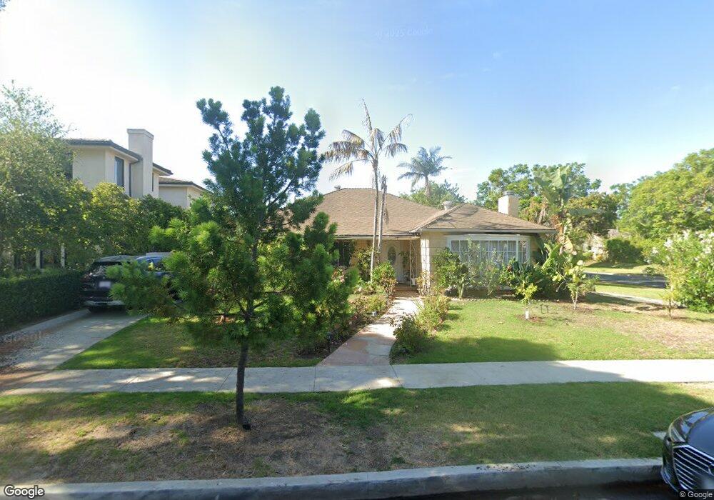
9632 Kirkside Rd Los Angeles, CA 90035
Beverlywood NeighborhoodEstimated Value: $2,683,000 - $2,994,000
3
Beds
3
Baths
2,311
Sq Ft
$1,252/Sq Ft
Est. Value
About This Home
This home is located at 9632 Kirkside Rd, Los Angeles, CA 90035 and is currently estimated at $2,893,834, approximately $1,252 per square foot. 9632 Kirkside Rd is a home located in Los Angeles County with nearby schools including Canfield Avenue Elementary, Palms Middle School, and Alexander Hamilton Senior High School.
Ownership History
Date
Name
Owned For
Owner Type
Purchase Details
Closed on
Jul 30, 2002
Sold by
Koyghadoush Ashraf
Bought by
Koyghadoush Ashraf and The Ashraf Koyghadoush Trust
Current Estimated Value
Purchase Details
Closed on
May 21, 2001
Sold by
Azizi Robert
Bought by
Koyghadoush Ashraf
Purchase Details
Closed on
Mar 12, 2001
Sold by
Eastman Henri M and Eastman Clarisse
Bought by
Azizi Robert
Home Financials for this Owner
Home Financials are based on the most recent Mortgage that was taken out on this home.
Original Mortgage
$480,000
Interest Rate
7.25%
Create a Home Valuation Report for This Property
The Home Valuation Report is an in-depth analysis detailing your home's value as well as a comparison with similar homes in the area
Home Values in the Area
Average Home Value in this Area
Purchase History
| Date | Buyer | Sale Price | Title Company |
|---|---|---|---|
| Koyghadoush Ashraf | -- | -- | |
| Koyghadoush Ashraf | -- | -- | |
| Azizi Robert | $600,000 | Commonwealth Land Title Co |
Source: Public Records
Mortgage History
| Date | Status | Borrower | Loan Amount |
|---|---|---|---|
| Previous Owner | Azizi Robert | $480,000 |
Source: Public Records
Tax History Compared to Growth
Tax History
| Year | Tax Paid | Tax Assessment Tax Assessment Total Assessment is a certain percentage of the fair market value that is determined by local assessors to be the total taxable value of land and additions on the property. | Land | Improvement |
|---|---|---|---|---|
| 2025 | $11,018 | $904,085 | $723,276 | $180,809 |
| 2024 | $11,018 | $886,359 | $709,095 | $177,264 |
| 2023 | $10,811 | $868,981 | $695,192 | $173,789 |
| 2022 | $10,318 | $851,943 | $681,561 | $170,382 |
| 2021 | $10,183 | $835,240 | $668,198 | $167,042 |
| 2019 | $9,882 | $810,469 | $648,380 | $162,089 |
| 2018 | $9,741 | $794,578 | $635,667 | $158,911 |
| 2016 | $9,306 | $763,726 | $610,984 | $152,742 |
| 2015 | $9,170 | $752,255 | $601,807 | $150,448 |
| 2014 | $9,203 | $737,520 | $590,019 | $147,501 |
Source: Public Records
Map
Nearby Homes
- 9730 Cresta Dr
- 1601 S Beverly Dr
- 1625 Rexford Dr
- 2299 Beverwil Dr
- 9313 Bolton Rd
- 1450 S Beverly Dr Unit 105
- 2671 Anchor Ave
- 2700 Anchor Ave
- 2714 Forrester Dr
- 2718 Forrester Dr
- 9142 Monte Mar Dr
- 1333 Beverly Green Dr Unit 301
- 1318 S Roxbury Dr Unit 118
- 2775 Motor Ave
- 1618 S Durango Ave
- 1220 Smithwood Dr
- 1115 S Elm Dr Unit 401
- 1115 S Elm Dr Unit 207
- 1115 S Elm Dr Unit 301
- 1115 S Elm Dr Unit 417
- 9626 Kirkside Rd
- 9622 Kirkside Rd
- 9635 Oakmore Rd
- 9631 Oakmore Rd
- 9616 Kirkside Rd
- 9625 Oakmore Rd
- 9635 Kirkside Rd
- 9700 Kirkside Rd
- 9629 Kirkside Rd
- 9623 Kirkside Rd
- 9701 Oakmore Rd
- 9619 Oakmore Rd
- 9610 Kirkside Rd
- 9617 Kirkside Rd
- 9706 Kirkside Rd
- 9707 Oakmore Rd
- 9701 Kirkside Rd
- 9613 Oakmore Rd
- 9613 Kirkside Rd
- 9606 Kirkside Rd