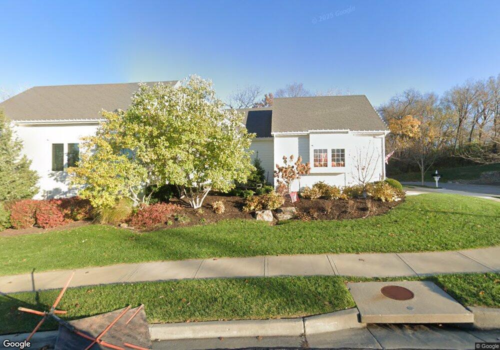
9657 Lime Stone Rd Unit 17-2 Kansas City, MO 64152
Estimated Value: $343,000 - $643,000
3
Beds
3
Baths
1,858
Sq Ft
$280/Sq Ft
Est. Value
About This Home
This home is located at 9657 Lime Stone Rd Unit 17-2, Kansas City, MO 64152 and is currently estimated at $519,478, approximately $279 per square foot. 9657 Lime Stone Rd Unit 17-2 is a home located in Platte County with nearby schools including Graden Elementary School, Lakeview Middle School, and Plaza Middle School.
Ownership History
Date
Name
Owned For
Owner Type
Purchase Details
Closed on
Apr 22, 2011
Sold by
National Residential Development Co Llc
Bought by
Gutshall Harry
Current Estimated Value
Home Financials for this Owner
Home Financials are based on the most recent Mortgage that was taken out on this home.
Original Mortgage
$200,000
Outstanding Balance
$138,194
Interest Rate
4.91%
Mortgage Type
New Conventional
Estimated Equity
$381,284
Create a Home Valuation Report for This Property
The Home Valuation Report is an in-depth analysis detailing your home's value as well as a comparison with similar homes in the area
Home Values in the Area
Average Home Value in this Area
Purchase History
| Date | Buyer | Sale Price | Title Company |
|---|---|---|---|
| Gutshall Harry | -- | -- |
Source: Public Records
Mortgage History
| Date | Status | Borrower | Loan Amount |
|---|---|---|---|
| Open | Gutshall Harry | $200,000 |
Source: Public Records
Tax History Compared to Growth
Tax History
| Year | Tax Paid | Tax Assessment Tax Assessment Total Assessment is a certain percentage of the fair market value that is determined by local assessors to be the total taxable value of land and additions on the property. | Land | Improvement |
|---|---|---|---|---|
| 2025 | $7,159 | $80,438 | $10,450 | $69,988 |
| 2024 | $7,168 | $80,438 | $10,450 | $69,988 |
| 2023 | $7,168 | $80,438 | $10,450 | $69,988 |
| 2022 | $6,768 | $74,480 | $10,450 | $64,030 |
| 2021 | $6,785 | $74,480 | $10,450 | $64,030 |
| 2020 | $6,988 | $74,480 | $10,450 | $64,030 |
| 2019 | $6,988 | $74,480 | $10,450 | $64,030 |
| 2018 | $7,139 | $74,480 | $10,450 | $64,030 |
| 2017 | $7,114 | $74,480 | $10,450 | $64,030 |
| 2016 | $7,215 | $74,480 | $10,450 | $64,030 |
| 2015 | $7,246 | $74,480 | $10,450 | $64,030 |
| 2013 | $4,182 | $74,480 | $0 | $0 |
Source: Public Records
Map
Nearby Homes
- 5920 S National Dr
- 6130 S National Dr
- 9785 S Ambrosia Ln
- 9815 S Ambrosia Ln
- 10013 NW Crooked Rd
- 6122 Persimmon Ct
- 10105 NW River Hills Dr
- 6448 NW Cross Rd
- 10600 Overlook Ln
- Madison IV Plan at Riss Lake - The Sanctuary
- Courtland Reverse Plan at Riss Lake - The Sanctuary
- Brookridge IV Plan at Riss Lake - The Sanctuary
- 10119 River Hills Dr
- 6006 W Shore Ct
- 5831 Lentz Dr
- 5826 Lentz Dr
- 10755 Genesis Dr
- 10600 Genesis Dr
- 10563 Genesis Dr
- 5751 Lentz Dr
- 9657 Lime Stone Rd
- 9633 Lime Stone Rd Unit 17-1
- 6047 S National Dr
- 6039 S National Dr Unit 18-2
- 6039 S National Dr
- 6033 S National Dr
- 9549 Lime Stone Rd Unit 15-2
- 6027 S National Dr
- 9561 Lime Stone Rd Unit 15-3
- 9573 Lime Stone Rd Unit 15-1
- 9573 Lime Stone Rd
- 9537 Lime Stone Rd Unit 15-1
- 9525 Lime Stone Rd Unit 14-4
- 9513 Lime Stone Rd Unit 14-3
- 9513 Lime Stone Rd
- 6203 Heathery Way
- 9489 Lime Stone Rd Unit 14-1
- 6102 Double Eagle Ct
- 6102 Double Eagle Ct
- 9501 Lime Stone Rd Unit 14-2