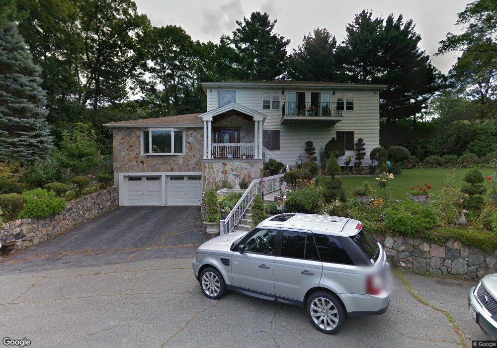
97 Leslie Rd Waltham, MA 02451
North Waltham NeighborhoodEstimated Value: $1,138,000 - $1,554,000
3
Beds
3
Baths
2,743
Sq Ft
$455/Sq Ft
Est. Value
About This Home
This home is located at 97 Leslie Rd, Waltham, MA 02451 and is currently estimated at $1,246,734, approximately $454 per square foot. 97 Leslie Rd is a home located in Middlesex County with nearby schools including Douglas Macarthur Elementary School, John F Kennedy Middle School, and Waltham Sr High School.
Ownership History
Date
Name
Owned For
Owner Type
Purchase Details
Closed on
Apr 13, 2022
Sold by
Swenson Daniel F
Bought by
Swenson Daniel F and Swenson Abby
Current Estimated Value
Purchase Details
Closed on
Jul 14, 2017
Sold by
Swenson Daniel F and Dunne Adrienne D
Bought by
Swenson Daniel F
Purchase Details
Closed on
Apr 29, 1993
Sold by
Casalinova Ronald P and Casalinova Janice
Bought by
Swenson Daniel F
Home Financials for this Owner
Home Financials are based on the most recent Mortgage that was taken out on this home.
Original Mortgage
$220,000
Interest Rate
7.51%
Mortgage Type
Purchase Money Mortgage
Create a Home Valuation Report for This Property
The Home Valuation Report is an in-depth analysis detailing your home's value as well as a comparison with similar homes in the area
Home Values in the Area
Average Home Value in this Area
Purchase History
| Date | Buyer | Sale Price | Title Company |
|---|---|---|---|
| Swenson Daniel F | -- | None Available | |
| Swenson Daniel F | -- | -- | |
| Swenson Daniel F | $260,000 | -- |
Source: Public Records
Mortgage History
| Date | Status | Borrower | Loan Amount |
|---|---|---|---|
| Previous Owner | Swenson Daniel F | $187,700 | |
| Previous Owner | Swenson Daniel F | $220,000 |
Source: Public Records
Tax History
| Year | Tax Paid | Tax Assessment Tax Assessment Total Assessment is a certain percentage of the fair market value that is determined by local assessors to be the total taxable value of land and additions on the property. | Land | Improvement |
|---|---|---|---|---|
| 2025 | $9,756 | $993,500 | $530,600 | $462,900 |
| 2024 | $9,265 | $961,100 | $505,600 | $455,500 |
| 2023 | $9,213 | $892,700 | $460,600 | $432,100 |
| 2022 | $9,369 | $841,000 | $440,600 | $400,400 |
| 2021 | $9,282 | $820,000 | $440,600 | $379,400 |
| 2020 | $9,184 | $768,500 | $410,600 | $357,900 |
| 2019 | $9,679 | $764,500 | $406,600 | $357,900 |
| 2018 | $8,814 | $699,000 | $376,600 | $322,400 |
| 2017 | $8,264 | $658,000 | $335,600 | $322,400 |
| 2016 | $7,442 | $608,000 | $285,600 | $322,400 |
| 2015 | $7,517 | $572,500 | $285,600 | $286,900 |
Source: Public Records
Map
Nearby Homes
- 77 Old County Rd
- 69 Page Rd
- 84 Davison Dr
- 45 Winter St
- 167 Lexington Rd N
- 7 Field Rd
- 14 Benjamin Rd
- 89 Lexington Rd
- 10 Reiling Pond Rd
- 22 Fairbanks Rd
- 11 Autumn Ln
- 44 Lakeview Terrace
- 89 Hardy Pond Rd
- 8 Phinney Rd
- 8 Silver Hill Rd
- 8 Dobbins St
- 21 Lakeview Ave
- 28 Tufts Rd
- 183 Kings Grant Rd
- 15 Cedarcroft Ln
- 95 Leslie Rd
- 105 Leslie Rd
- 31 Woodchester Cir
- 41 Agrillo Cir
- 36 Woodchester Cir
- 91 Leslie Rd
- 91 Leslie Rd
- 29 Agrillo Cir
- 60 Woodchester Rd
- 47 Agrillo Cir
- 15 Agrillo Cir
- 1776 Trapelo Rd
- 15 Woodchester Cir
- 100 Leslie Rd
- 90 Leslie Rd
- 110 Leslie Rd
- 30 Woodchester Cir
- 26 Agrillo Cir
- 45 Leslie Rd
- 80 Leslie Rd
Your Personal Tour Guide
Ask me questions while you tour the home.