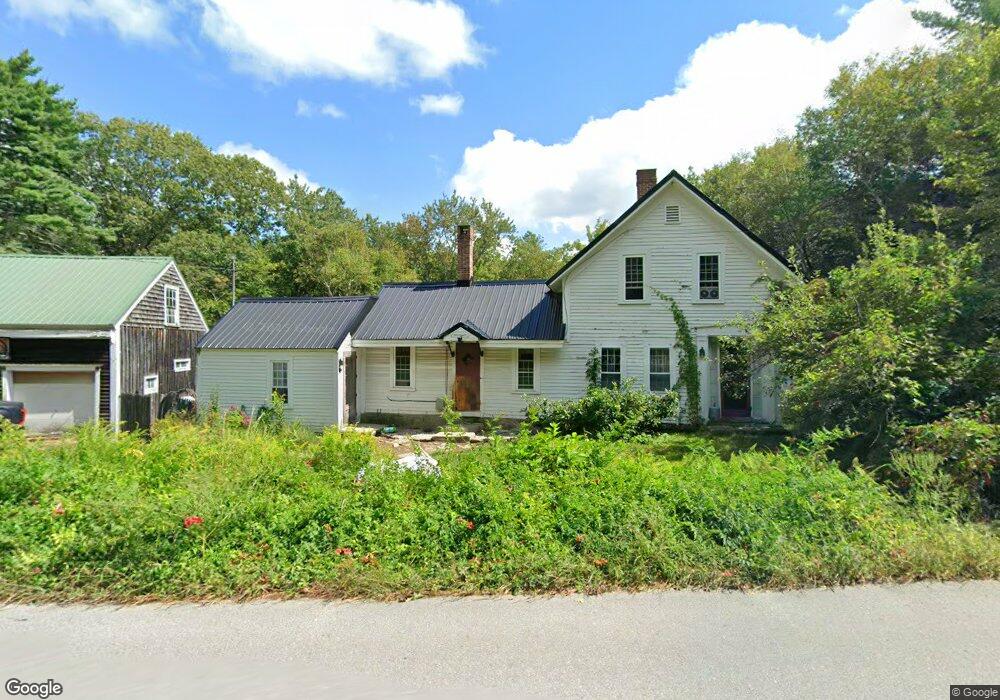
970 Center Rd Lyndeborough, NH 03082
Estimated Value: $380,000 - $562,000
3
Beds
1
Bath
1,790
Sq Ft
$265/Sq Ft
Est. Value
About This Home
This home is located at 970 Center Rd, Lyndeborough, NH 03082 and is currently estimated at $474,276, approximately $264 per square foot. 970 Center Rd is a home located in Hillsborough County with nearby schools including Lyndeborough Central School, Wilton-Lyndeborough Cooperative Middle School, and Wilton-Lyndeborough Cooperative High School.
Ownership History
Date
Name
Owned For
Owner Type
Purchase Details
Closed on
Jul 24, 2019
Sold by
Carson George J and Carson Jessica L
Bought by
Carson George J and Carson Jessica L
Current Estimated Value
Home Financials for this Owner
Home Financials are based on the most recent Mortgage that was taken out on this home.
Original Mortgage
$186,700
Interest Rate
3.73%
Mortgage Type
New Conventional
Purchase Details
Closed on
Aug 24, 2010
Sold by
Kelczewski Barbara A
Bought by
Carson George J and Liperti Jessica L
Home Financials for this Owner
Home Financials are based on the most recent Mortgage that was taken out on this home.
Original Mortgage
$222,872
Interest Rate
4.63%
Mortgage Type
Purchase Money Mortgage
Create a Home Valuation Report for This Property
The Home Valuation Report is an in-depth analysis detailing your home's value as well as a comparison with similar homes in the area
Home Values in the Area
Average Home Value in this Area
Purchase History
| Date | Buyer | Sale Price | Title Company |
|---|---|---|---|
| Carson George J | -- | -- | |
| Carson George J | -- | -- | |
| Carson George J | $232,500 | -- |
Source: Public Records
Mortgage History
| Date | Status | Borrower | Loan Amount |
|---|---|---|---|
| Previous Owner | Carson George J | $186,700 | |
| Previous Owner | Carson George J | $222,872 |
Source: Public Records
Tax History
| Year | Tax Paid | Tax Assessment Tax Assessment Total Assessment is a certain percentage of the fair market value that is determined by local assessors to be the total taxable value of land and additions on the property. | Land | Improvement |
|---|---|---|---|---|
| 2025 | $5,955 | $350,900 | $153,200 | $197,700 |
| 2024 | $6,175 | $238,800 | $89,600 | $149,200 |
| 2023 | $5,676 | $238,800 | $89,600 | $149,200 |
| 2022 | $5,277 | $238,800 | $89,600 | $149,200 |
| 2021 | $5,260 | $238,000 | $89,600 | $148,400 |
| 2020 | $5,079 | $238,000 | $89,600 | $148,400 |
| 2019 | $6,175 | $211,900 | $89,900 | $122,000 |
| 2018 | $5,978 | $211,900 | $89,900 | $122,000 |
| 2017 | $5,878 | $211,900 | $89,900 | $122,000 |
| 2016 | $5,878 | $211,900 | $89,900 | $122,000 |
| 2015 | $5,359 | $211,900 | $89,900 | $122,000 |
| 2013 | $5,028 | $209,500 | $91,600 | $117,900 |
Source: Public Records
Map
Nearby Homes
- 6 Mottau Dr
- 144 Putnam Hill Rd
- Lot 3-70 Locust Ln
- 41 Cooper Ln
- 77 Salisbury Rd
- 116 Beech Hill Rd
- A 66 Burton Hwy
- 371 Burton Hwy
- 374 Burton Hwy
- 58-6-2 Duggin Rd
- 25 Burns Hill Rd
- 7 Dow Rd
- 10 Whiting Hill Rd
- 44 Pearson Ln
- 4 Trow Rd
- 171 S Hill Rd
- 33 Falcon Ridge Rd Unit 33
- 23 Falcon Ridge Rd Unit 23
- 24 Falcon Ridge Rd Unit 24
- 2-47 Old Amherst Rd
Your Personal Tour Guide
Ask me questions while you tour the home.