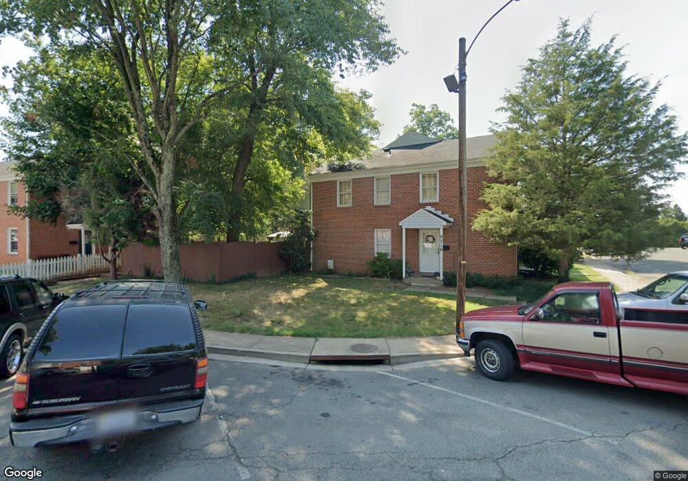
9710 Bragg Ln Manassas, VA 20110
Old Town Manassas NeighborhoodEstimated Value: $337,000 - $351,000
3
Beds
3
Baths
1,188
Sq Ft
$289/Sq Ft
Est. Value
About This Home
This home is located at 9710 Bragg Ln, Manassas, VA 20110 and is currently estimated at $343,130, approximately $288 per square foot. 9710 Bragg Ln is a home located in Manassas City with nearby schools including Jennie Dean Elementary School, Mayfield Intermediate School, and Grace E. Metz Middle School.
Ownership History
Date
Name
Owned For
Owner Type
Purchase Details
Closed on
Nov 13, 2017
Sold by
Hempen Mark A and Hempen Ann K
Bought by
Bragg Incestments Llc
Current Estimated Value
Purchase Details
Closed on
Jul 26, 1999
Sold by
Taggart Anne L
Bought by
Planes Gene
Home Financials for this Owner
Home Financials are based on the most recent Mortgage that was taken out on this home.
Original Mortgage
$55,920
Interest Rate
7.49%
Create a Home Valuation Report for This Property
The Home Valuation Report is an in-depth analysis detailing your home's value as well as a comparison with similar homes in the area
Home Values in the Area
Average Home Value in this Area
Purchase History
| Date | Buyer | Sale Price | Title Company |
|---|---|---|---|
| Bragg Incestments Llc | -- | None Available | |
| Planes Gene | $69,900 | -- |
Source: Public Records
Mortgage History
| Date | Status | Borrower | Loan Amount |
|---|---|---|---|
| Previous Owner | Planes Gene | $55,920 |
Source: Public Records
Tax History Compared to Growth
Tax History
| Year | Tax Paid | Tax Assessment Tax Assessment Total Assessment is a certain percentage of the fair market value that is determined by local assessors to be the total taxable value of land and additions on the property. | Land | Improvement |
|---|---|---|---|---|
| 2024 | $3,362 | $266,800 | $88,000 | $178,800 |
| 2023 | $3,079 | $244,400 | $83,000 | $161,400 |
| 2022 | $2,868 | $213,700 | $72,000 | $141,700 |
| 2021 | $2,664 | $186,400 | $64,500 | $121,900 |
| 2020 | $2,523 | $172,800 | $62,500 | $110,300 |
| 2019 | $2,364 | $159,700 | $61,000 | $98,700 |
| 2018 | $2,241 | $153,500 | $58,000 | $95,500 |
| 2017 | -- | $150,300 | $58,000 | $92,300 |
| 2016 | $1,974 | $140,700 | $0 | $0 |
| 2015 | -- | $140,700 | $58,000 | $82,700 |
| 2014 | -- | $0 | $0 | $0 |
Source: Public Records
Map
Nearby Homes
- 9269 George St
- 9319 Woodlea Ct
- 9332 Wax Myrtle Way
- 9278 Taney Rd
- 9305 Gooseberry Dr
- 9352 Wax Myrtle Way
- 9524 Barnes Loop
- 9008 Coriander Cir
- 9520 Barnes Loop
- 9229 Prince William St
- 9204 Douglas St
- 9563 Jefferson St
- 9781 Mock Orange Ct
- 9623 Grant Ave
- 9639 Grant Ave
- 9718 Pickett Ln
- 9669 Swallowtail Ln
- 9671 Swallowtail Ln
- Harrington Plan at Ashberry
- Wentworth Plan at Ashberry