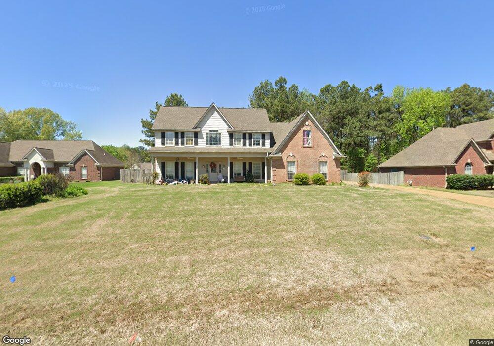
9774 Leslie Ln Olive Branch, MS 38654
Estimated Value: $347,000 - $381,247
3
Beds
3
Baths
2,351
Sq Ft
$154/Sq Ft
Est. Value
About This Home
This home is located at 9774 Leslie Ln, Olive Branch, MS 38654 and is currently estimated at $363,062, approximately $154 per square foot. 9774 Leslie Ln is a home located in DeSoto County with nearby schools including Chickasaw Elementary School, Olive Branch Middle School, and Olive Branch High School.
Ownership History
Date
Name
Owned For
Owner Type
Purchase Details
Closed on
Sep 29, 2008
Sold by
Warren Gwendolyn and Warren William C
Bought by
Molasky Aaron B
Current Estimated Value
Home Financials for this Owner
Home Financials are based on the most recent Mortgage that was taken out on this home.
Original Mortgage
$193,500
Outstanding Balance
$127,215
Interest Rate
6.45%
Mortgage Type
Purchase Money Mortgage
Estimated Equity
$235,847
Create a Home Valuation Report for This Property
The Home Valuation Report is an in-depth analysis detailing your home's value as well as a comparison with similar homes in the area
Home Values in the Area
Average Home Value in this Area
Purchase History
| Date | Buyer | Sale Price | Title Company |
|---|---|---|---|
| Molasky Aaron B | -- | None Available |
Source: Public Records
Mortgage History
| Date | Status | Borrower | Loan Amount |
|---|---|---|---|
| Open | Molasky Aaron B | $193,500 |
Source: Public Records
Tax History Compared to Growth
Tax History
| Year | Tax Paid | Tax Assessment Tax Assessment Total Assessment is a certain percentage of the fair market value that is determined by local assessors to be the total taxable value of land and additions on the property. | Land | Improvement |
|---|---|---|---|---|
| 2024 | $2,410 | $19,857 | $3,500 | $16,357 |
| 2023 | $2,410 | $19,857 | $0 | $0 |
| 2022 | $2,410 | $19,857 | $3,500 | $16,357 |
| 2021 | $2,410 | $19,857 | $3,500 | $16,357 |
| 2020 | $2,232 | $18,550 | $3,500 | $15,050 |
| 2019 | $2,066 | $17,338 | $3,500 | $13,838 |
| 2017 | $2,030 | $30,460 | $16,980 | $13,480 |
| 2016 | $2,030 | $16,980 | $3,500 | $13,480 |
| 2015 | $2,330 | $30,460 | $16,980 | $13,480 |
| 2014 | $2,030 | $16,980 | $0 | $0 |
| 2013 | $2,018 | $16,980 | $0 | $0 |
Source: Public Records
Map
Nearby Homes
- 10321 Loftin Dr
- 10262 March Meadows Way
- 10640 Mississippi 178
- 10719 Highway 178
- 9598 Nielsen Dr
- 10369 French Fort Dr
- 9653 Trenton Trail
- 4630 Alexander Rd
- 9635 Austin Dr
- 5195 Mary Ln N
- 5806 Southbend Ln
- 5619 Eagleston Dr
- 10488 Parker Dr Dr Unit Ext
- 8754 Ln
- 0 Hacks Rd Unit 4132565
- 2914 Cypress Lake Dr S
- 6032 Robby Cove
- 5155 Rolling Pine Cir
- 6144 Magnolia Lakes Dr
- 4213 Sidlehill Dr