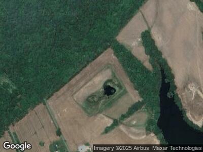
9799 Fairview Point Ln Easton, MD 21601
Estimated Value: $1,027,343 - $3,717,000
3
Beds
1
Bath
1,825
Sq Ft
$1,105/Sq Ft
Est. Value
About This Home
This home is located at 9799 Fairview Point Ln, Easton, MD 21601 and is currently estimated at $2,016,114, approximately $1,104 per square foot. 9799 Fairview Point Ln is a home located in Talbot County with nearby schools including St. Michaels Elementary School, St. Michaels Middle/High School, and Easton High School.
Ownership History
Date
Name
Owned For
Owner Type
Purchase Details
Closed on
Feb 12, 2021
Sold by
Leds Creek Holdings Llc
Bought by
9799 Fairview Llc
Current Estimated Value
Home Financials for this Owner
Home Financials are based on the most recent Mortgage that was taken out on this home.
Original Mortgage
$1,987,500
Outstanding Balance
$1,804,417
Interest Rate
2.65%
Mortgage Type
New Conventional
Estimated Equity
$157,404
Purchase Details
Closed on
Sep 6, 2008
Sold by
Thompson Peter S
Bought by
Leeds Creek Holdings Llc
Create a Home Valuation Report for This Property
The Home Valuation Report is an in-depth analysis detailing your home's value as well as a comparison with similar homes in the area
Home Values in the Area
Average Home Value in this Area
Purchase History
| Date | Buyer | Sale Price | Title Company |
|---|---|---|---|
| 9799 Fairview Llc | $3,300,000 | Chicago Title Insurance Co | |
| Leeds Creek Holdings Llc | $2,050,000 | -- |
Source: Public Records
Mortgage History
| Date | Status | Borrower | Loan Amount |
|---|---|---|---|
| Open | 9799 Fairview Llc | $1,987,500 |
Source: Public Records
Tax History Compared to Growth
Tax History
| Year | Tax Paid | Tax Assessment Tax Assessment Total Assessment is a certain percentage of the fair market value that is determined by local assessors to be the total taxable value of land and additions on the property. | Land | Improvement |
|---|---|---|---|---|
| 2024 | $3,279 | $359,600 | $98,000 | $261,600 |
| 2023 | $3,056 | $353,300 | $0 | $0 |
| 2022 | $2,792 | $347,000 | $0 | $0 |
| 2021 | $2,656 | $340,700 | $98,000 | $242,700 |
| 2020 | $2,497 | $328,100 | $0 | $0 |
| 2019 | $2,404 | $315,500 | $0 | $0 |
| 2018 | $2,217 | $302,900 | $98,000 | $204,900 |
| 2017 | $2,050 | $302,433 | $0 | $0 |
| 2016 | $1,175 | $301,967 | $0 | $0 |
| 2015 | $1,262 | $182,800 | $0 | $0 |
| 2014 | $1,262 | $182,800 | $0 | $0 |
Source: Public Records
Map
Nearby Homes
- 9501 Unionville Rd
- 0 Unionville Rd Unit MDTA2008824
- 24749 Swan Rd
- 8543 Ingleton Rd
- 9783 Unionville Rd
- 27029 Miles River Rd
- 9191 Deepwater Point Rd
- 24580 Deepwater Point Dr Unit 4
- 8419 Ingleton Rd
- 24560 Deepwater Point Dr Unit 1
- 8320 Ingleton Cir
- 27168 Anchorage Rd
- 9531 Quail Hollow Dr Unit 403
- 9171 Deepwater Point Rd
- 9545 Quail Hollow Dr Unit 206
- 9529 Quail Hollow Dr Unit 503
- 1026 Riverview Terrace
- 0 Radcliff Ave Unit MDTA2007626
- 110 Lee St
- 402 N Talbot St
- 9799 Fairview Point Ln
- 9729 Fairview Point Ln
- 9672 Leeds Landing Cir
- 9711 Fairview Point Ln
- 9668 Leeds Landing Cir
- 9684 Leeds Landing Cir
- 9702 Leeds Landing Cir
- 9664 Leeds Landing Cir
- 9704 Leeds Landing Cir
- 9660 Leeds Landing Cir
- 9800 Mill Point Rd
- 9798 Mill Point Rd
- 9380 Gregory Rd
- 9656 Leeds Landing Cir
- 9810 Mill Point Rd
- 9698 Leeds Landing Rd
- 9652 Leeds Landing Cir
- 9796 Mill Point Rd
- 9790 Mill Point Rd
- 9795 Mill Point Rd
