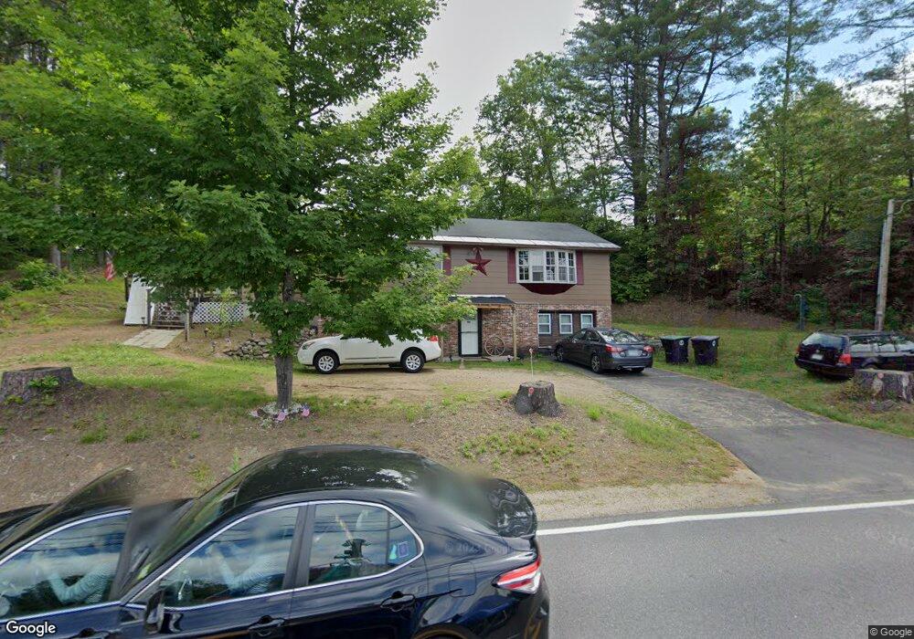
99 New Hampton Rd Franklin, NH 03235
Estimated Value: $360,000 - $402,000
2
Beds
2
Baths
1,559
Sq Ft
$241/Sq Ft
Est. Value
About This Home
This home is located at 99 New Hampton Rd, Franklin, NH 03235 and is currently estimated at $375,422, approximately $240 per square foot. 99 New Hampton Rd is a home located in Merrimack County with nearby schools including Paul A. Smith School, Franklin Middle School, and Franklin High School.
Ownership History
Date
Name
Owned For
Owner Type
Purchase Details
Closed on
Dec 5, 2016
Sold by
Dow Raymond A
Bought by
Dow Edward B and Dow Paula P
Current Estimated Value
Home Financials for this Owner
Home Financials are based on the most recent Mortgage that was taken out on this home.
Original Mortgage
$141,432
Outstanding Balance
$113,241
Interest Rate
3.25%
Mortgage Type
FHA
Estimated Equity
$262,181
Create a Home Valuation Report for This Property
The Home Valuation Report is an in-depth analysis detailing your home's value as well as a comparison with similar homes in the area
Home Values in the Area
Average Home Value in this Area
Purchase History
| Date | Buyer | Sale Price | Title Company |
|---|---|---|---|
| Dow Edward B | $145,000 | -- |
Source: Public Records
Mortgage History
| Date | Status | Borrower | Loan Amount |
|---|---|---|---|
| Open | Dow Edward B | $141,432 |
Source: Public Records
Tax History Compared to Growth
Tax History
| Year | Tax Paid | Tax Assessment Tax Assessment Total Assessment is a certain percentage of the fair market value that is determined by local assessors to be the total taxable value of land and additions on the property. | Land | Improvement |
|---|---|---|---|---|
| 2024 | $4,342 | $253,200 | $80,600 | $172,600 |
| 2023 | $4,117 | $253,200 | $80,600 | $172,600 |
| 2022 | $3,978 | $163,100 | $67,100 | $96,000 |
| 2021 | $3,786 | $163,100 | $67,100 | $96,000 |
| 2020 | $3,725 | $163,100 | $67,100 | $96,000 |
| 2019 | $3,676 | $163,600 | $67,100 | $96,500 |
| 2018 | $3,593 | $163,600 | $67,100 | $96,500 |
| 2017 | $3,525 | $137,900 | $29,000 | $108,900 |
| 2016 | $3,477 | $137,800 | $29,000 | $108,800 |
| 2015 | $2,407 | $96,460 | $20,300 | $76,160 |
| 2011 | $3,342 | $155,300 | $29,000 | $126,300 |
Source: Public Records
Map
Nearby Homes
- 104 New Hampton Rd
- 21 Mountain View Dr
- 251 Hill Rd
- 319 Victory Dr
- 00 Finch and Kidder Ave
- Lot 4 Piper St
- 208 Sanborn St
- 9 Hunt Ave
- 8 Smiling Hill Rd
- 0 Rowell Dr Unit 406 5043422
- 42 Woodrow Ave
- 69 Lake Ave
- 225 Kendall St
- 21 Lake Ave
- 693 Hill Rd
- 193 Kendall St
- 11 Racine St
- 180 Kendall St
- 28 Pine Colony Rd
- 53 Lark St
- 7 Madeline St
- 9 Madeline St
- 5 Madeline St
- 0 Madeline St Unit 2825871
- 0 Madeline St Unit Lot 113 -18 4855092
- 109 New Hampton Rd
- 108 New Hampton Rd
- 18 Madeline St
- 3 Jeannette St
- 4 Jeannette St
- 92 New Hampton Rd
- 3 Madeline St
- 6 Madeline St
- 1 Frances St
- 83 New Hampton Rd
- 3 Frances St
- 4 Madeline St
- 7 Robert St
- 5 Robert St
- 2 Jeannette St