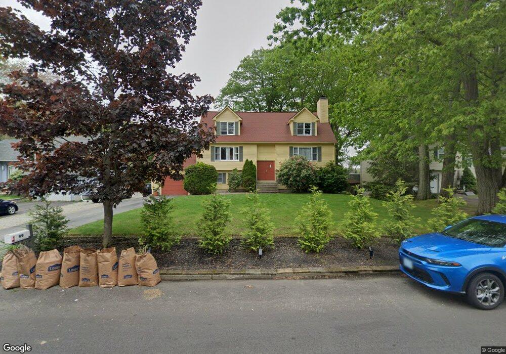
99 Tomahawk Trail Cranston, RI 02921
Western Cranston NeighborhoodEstimated Value: $604,137 - $662,000
3
Beds
2
Baths
1,806
Sq Ft
$352/Sq Ft
Est. Value
About This Home
This home is located at 99 Tomahawk Trail, Cranston, RI 02921 and is currently estimated at $636,534, approximately $352 per square foot. 99 Tomahawk Trail is a home located in Providence County with nearby schools including Orchard Farms El. School, Hope Highlands Middle School, and Cranston High School West.
Ownership History
Date
Name
Owned For
Owner Type
Purchase Details
Closed on
May 2, 2007
Sold by
Montminy Nancy
Bought by
Ben-Porat Anat Feniger and Nadar Nadav
Current Estimated Value
Create a Home Valuation Report for This Property
The Home Valuation Report is an in-depth analysis detailing your home's value as well as a comparison with similar homes in the area
Home Values in the Area
Average Home Value in this Area
Purchase History
| Date | Buyer | Sale Price | Title Company |
|---|---|---|---|
| Ben-Porat Anat Feniger | $315,000 | -- |
Source: Public Records
Mortgage History
| Date | Status | Borrower | Loan Amount |
|---|---|---|---|
| Open | Ben-Porat Anat Feniger | $38,700 | |
| Open | Ben-Porat Anat Feniger | $218,648 | |
| Closed | Ben-Porat Anat Feniger | $34,400 |
Source: Public Records
Tax History Compared to Growth
Tax History
| Year | Tax Paid | Tax Assessment Tax Assessment Total Assessment is a certain percentage of the fair market value that is determined by local assessors to be the total taxable value of land and additions on the property. | Land | Improvement |
|---|---|---|---|---|
| 2025 | $6,543 | $471,400 | $138,400 | $333,000 |
| 2024 | $6,416 | $471,400 | $138,400 | $333,000 |
| 2023 | $6,337 | $335,300 | $99,000 | $236,300 |
| 2022 | $6,206 | $335,300 | $99,000 | $236,300 |
| 2021 | $6,035 | $335,300 | $99,000 | $236,300 |
| 2020 | $5,809 | $279,700 | $99,000 | $180,700 |
| 2019 | $5,809 | $279,700 | $99,000 | $180,700 |
| 2018 | $5,675 | $279,700 | $99,000 | $180,700 |
| 2017 | $5,425 | $236,500 | $84,900 | $151,600 |
| 2016 | $5,309 | $236,500 | $84,900 | $151,600 |
| 2015 | $5,309 | $236,500 | $84,900 | $151,600 |
| 2014 | $4,869 | $213,200 | $70,700 | $142,500 |
Source: Public Records
Map
Nearby Homes
- 80 Tomahawk Trail
- 102 Moccasin Trail
- 68 Fox Run
- 0 Anthony Dr Unit 1394338
- 2 Mulberry Dr
- 10 Honey Lou Ct
- 18 Quail Ridge Rd
- 121 Ashbrook Dr
- 311 Hope Rd
- 9 Gray Coach E
- 02 Paula Ln
- 01 Paula Ln
- 3 Equestrian Ln
- 12 Beechwood Dr
- 1213 Phenix Ave
- 105 Amy Dr
- 20 Doreen Ct
- 53 Charcalee Dr
- 95 Amy Dr
- 40 Phenix Ridge Dr
- 101 Tomahawk Trail
- 89 Tomahawk Trail
- 56 Indian Trail
- 100 Tomahawk Trail
- 96 Tomahawk Trail
- 111 Tomahawk Trail
- 85 Tomahawk Trail
- 108 Tomahawk Trail
- 90 Tomahawk Trail
- 60 Indian Trail
- 44 Indian Trail
- 137 Canonchet Trail
- 75 Tomahawk Trail
- 129 Canonchet Trail
- 10 Agawam Trail
- 123 Canonchet Trail
- 118 Tomahawk Trail
- 107 Canonchet Trail
- 36 Indian Trail
- 72 Tomahawk Trail