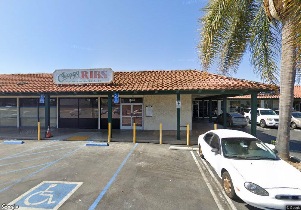
9901 Yorktown Ave Huntington Beach, CA 92646
Adams Neighborhood
--
Bed
--
Bath
21,477
Sq Ft
2.23
Acres
About This Home
This home is located at 9901 Yorktown Ave, Huntington Beach, CA 92646. 9901 Yorktown Ave is a home located in Orange County with nearby schools including Isojiro Oka Elementary, Talbert Middle School, and Huntington Beach High School.
Ownership History
Date
Name
Owned For
Owner Type
Purchase Details
Closed on
Aug 29, 2005
Sold by
Soos Cheryl S
Bought by
Jc Family Property Group Inc
Home Financials for this Owner
Home Financials are based on the most recent Mortgage that was taken out on this home.
Original Mortgage
$4,200,000
Outstanding Balance
$2,225,788
Interest Rate
5.7%
Mortgage Type
Commercial
Purchase Details
Closed on
Aug 16, 2000
Sold by
Southwell Grace H Trust
Bought by
Soos Cheryl S
Create a Home Valuation Report for This Property
The Home Valuation Report is an in-depth analysis detailing your home's value as well as a comparison with similar homes in the area
Home Values in the Area
Average Home Value in this Area
Purchase History
| Date | Buyer | Sale Price | Title Company |
|---|---|---|---|
| Jc Family Property Group Inc | -- | Chicago Title Co | |
| Soos Cheryl S | -- | -- |
Source: Public Records
Mortgage History
| Date | Status | Borrower | Loan Amount |
|---|---|---|---|
| Open | Jc Family Property Group Inc | $4,200,000 |
Source: Public Records
Tax History Compared to Growth
Tax History
| Year | Tax Paid | Tax Assessment Tax Assessment Total Assessment is a certain percentage of the fair market value that is determined by local assessors to be the total taxable value of land and additions on the property. | Land | Improvement |
|---|---|---|---|---|
| 2025 | $118,092 | $9,379,328 | $6,627,953 | $2,751,375 |
| 2024 | $118,092 | $9,151,666 | $6,497,994 | $2,653,672 |
| 2023 | $115,184 | $8,972,222 | $6,370,582 | $2,601,640 |
| 2022 | $113,584 | $8,821,194 | $6,245,669 | $2,575,525 |
| 2021 | $111,493 | $8,648,230 | $6,123,205 | $2,525,025 |
| 2020 | $110,769 | $8,559,554 | $6,060,420 | $2,499,134 |
| 2019 | $108,738 | $8,391,720 | $5,941,588 | $2,450,132 |
| 2018 | $106,744 | $8,227,177 | $5,825,086 | $2,402,091 |
| 2017 | $105,108 | $8,065,860 | $5,710,868 | $2,354,992 |
| 2016 | $100,951 | $7,907,706 | $5,598,890 | $2,308,816 |
| 2015 | $99,422 | $7,788,925 | $5,514,789 | $2,274,136 |
| 2014 | $97,493 | $7,636,351 | $5,406,762 | $2,229,589 |
Source: Public Records
Map
Nearby Homes
- 19361 Brookhurst St Unit 159
- 19361 Brookhurst St Unit 87
- 19361 Brookhurst St Unit 50
- 19361 Brookhurst St Unit 143
- 19361 Brookhurst St Unit 21
- 19361 Brookhurst St Unit 22
- 19361 Brookhurst St Unit 184
- 19361 Brookhurst St Unit 33
- 19251 Brookhurst St Unit 13
- 19251 Brookhurst St Unit 48
- 19251 Brookhurst St Unit 11
- 19251 Brookhurst St Unit 22
- 19251 Brookhurst St Unit 38
- 19251 Brookhurst St Unit 137
- 19251 Brookhurst St Unit 69
- 19774 Cambridge Ln
- 9831 Continental Dr
- 10151 Kukui Dr
- 19847 Kingswood Ln
- 9850 Garfield Ave Unit 129
- 9921 Frederick Cir
- 9931 Frederick Cir
- 9911 Frederick Cir
- 9951 Frederick Cir
- 9901 Frederick Cir
- 9891 Frederick Cir
- 9961 Frederick Cir
- 9871 Frederick Cir
- 9861 Frederick Cir
- 9922 Frederick Cir
- 9932 Frederick Cir
- 9912 Frederick Cir
- 9962 Frederick Cir
- 9841 Fair Tide Cir
- 9902 Frederick Cir
- 9842 Fair Tide Cir
- 9952 Frederick Cir
- 19452 Brookhurst St
- 19462 Brookhurst St
- 9892 Frederick Cir