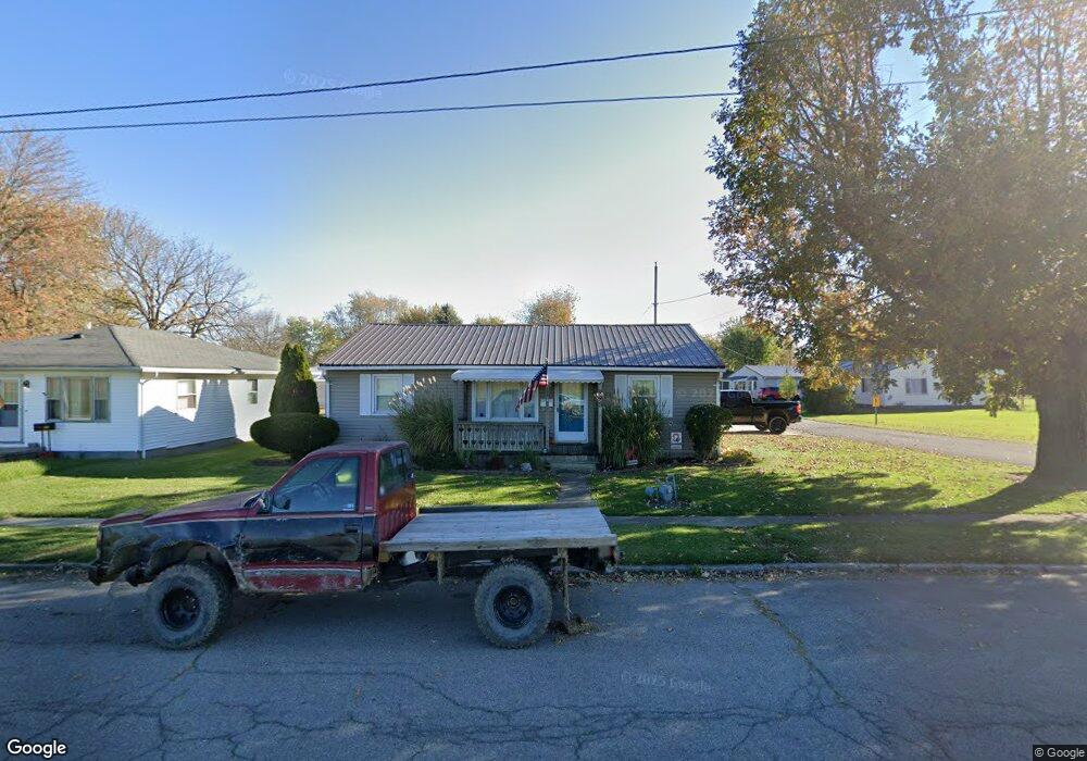
995 Steiner Ave Kenton, OH 43326
Estimated Value: $75,000 - $129,000
3
Beds
2
Baths
1,040
Sq Ft
$100/Sq Ft
Est. Value
About This Home
This home is located at 995 Steiner Ave, Kenton, OH 43326 and is currently estimated at $104,200, approximately $100 per square foot. 995 Steiner Ave is a home located in Hardin County with nearby schools including Kenton Elementary School, Kenton Middle School, and Kenton High School.
Ownership History
Date
Name
Owned For
Owner Type
Purchase Details
Closed on
Dec 4, 2003
Bought by
Moore Cynthia Kay
Current Estimated Value
Purchase Details
Closed on
Aug 27, 2003
Bought by
Bank One Na
Purchase Details
Closed on
May 13, 1994
Bought by
Oldham Maretta
Purchase Details
Closed on
Feb 1, 1993
Bought by
Brim Freda L
Purchase Details
Closed on
Jul 20, 1992
Purchase Details
Closed on
Feb 24, 1988
Purchase Details
Closed on
Aug 19, 1987
Create a Home Valuation Report for This Property
The Home Valuation Report is an in-depth analysis detailing your home's value as well as a comparison with similar homes in the area
Home Values in the Area
Average Home Value in this Area
Purchase History
| Date | Buyer | Sale Price | Title Company |
|---|---|---|---|
| Moore Cynthia Kay | $51,000 | -- | |
| Bank One Na | $36,000 | -- | |
| Oldham Maretta | $35,000 | -- | |
| Brim Freda L | $30,000 | -- | |
| -- | $14,500 | -- | |
| -- | -- | -- | |
| -- | -- | -- |
Source: Public Records
Tax History Compared to Growth
Tax History
| Year | Tax Paid | Tax Assessment Tax Assessment Total Assessment is a certain percentage of the fair market value that is determined by local assessors to be the total taxable value of land and additions on the property. | Land | Improvement |
|---|---|---|---|---|
| 2024 | $1,057 | $23,850 | $2,240 | $21,610 |
| 2023 | $1,057 | $23,850 | $2,240 | $21,610 |
| 2022 | $1,010 | $21,390 | $1,550 | $19,840 |
| 2021 | $1,013 | $21,390 | $1,550 | $19,840 |
| 2020 | $881 | $21,390 | $1,550 | $19,840 |
| 2019 | $688 | $17,380 | $1,480 | $15,900 |
| 2018 | $689 | $17,380 | $1,480 | $15,900 |
| 2017 | $664 | $17,380 | $1,480 | $15,900 |
| 2016 | $650 | $17,420 | $1,630 | $15,790 |
| 2015 | $628 | $17,420 | $1,630 | $15,790 |
| 2014 | $647 | $17,420 | $1,630 | $15,790 |
| 2013 | $739 | $19,180 | $1,630 | $17,550 |
Source: Public Records
Map
Nearby Homes
- 320 Letson Ave
- 727 S Detroit St
- 639 S Main St
- 414 Robinson Ave
- 508 Decatur St
- 510 Decatur St
- 13450 State Route 292
- 920 Cooper St
- 121 S High St
- 530 E Franklin St
- 513 E Franklin St
- 115 Scioto St
- 726 Tracy St
- 39 Grape St
- 219 W Carrol St
- 702 W Franklin St Unit 702 1/2
- 215 N Main St
- 79 Broadway St
- 0 Ohio 309
- 509 E Carrol St