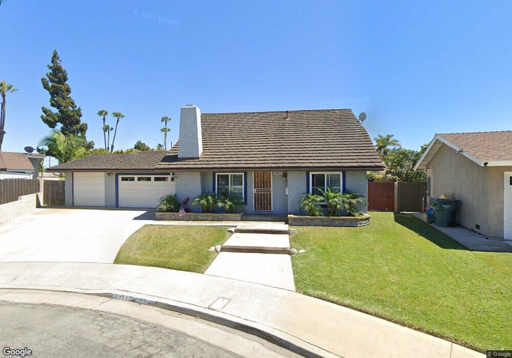
9952 Moore Cir Huntington Beach, CA 92646
Adams NeighborhoodEstimated Value: $1,038,000 - $1,401,000
2
Beds
2
Baths
1,608
Sq Ft
$773/Sq Ft
Est. Value
About This Home
This home is located at 9952 Moore Cir, Huntington Beach, CA 92646 and is currently estimated at $1,242,240, approximately $772 per square foot. 9952 Moore Cir is a home located in Orange County with nearby schools including Isojiro Oka Elementary, Talbert Middle School, and Huntington Beach High School.
Ownership History
Date
Name
Owned For
Owner Type
Purchase Details
Closed on
May 4, 2016
Sold by
Toledo Daniel Lee
Bought by
Toledo Daniel Lee and Daniel Lee Toledo Trust
Current Estimated Value
Purchase Details
Closed on
May 9, 1995
Sold by
Hart Elaine N
Bought by
Toledo Daniel L
Home Financials for this Owner
Home Financials are based on the most recent Mortgage that was taken out on this home.
Original Mortgage
$179,920
Interest Rate
8.37%
Purchase Details
Closed on
May 13, 1994
Sold by
Hart Thurman William
Bought by
Hart Elaine N
Create a Home Valuation Report for This Property
The Home Valuation Report is an in-depth analysis detailing your home's value as well as a comparison with similar homes in the area
Home Values in the Area
Average Home Value in this Area
Purchase History
| Date | Buyer | Sale Price | Title Company |
|---|---|---|---|
| Toledo Daniel Lee | -- | None Available | |
| Toledo Daniel L | $225,000 | Benefit Land Title Co | |
| Hart Elaine N | -- | -- |
Source: Public Records
Mortgage History
| Date | Status | Borrower | Loan Amount |
|---|---|---|---|
| Closed | Toledo Daniel L | $179,920 |
Source: Public Records
Tax History Compared to Growth
Tax History
| Year | Tax Paid | Tax Assessment Tax Assessment Total Assessment is a certain percentage of the fair market value that is determined by local assessors to be the total taxable value of land and additions on the property. | Land | Improvement |
|---|---|---|---|---|
| 2025 | $4,362 | $377,749 | $247,644 | $130,105 |
| 2024 | $4,362 | $370,343 | $242,789 | $127,554 |
| 2023 | $4,257 | $363,082 | $238,029 | $125,053 |
| 2022 | $4,191 | $355,963 | $233,362 | $122,601 |
| 2021 | $4,110 | $348,984 | $228,786 | $120,198 |
| 2020 | $4,085 | $345,406 | $226,440 | $118,966 |
| 2019 | $4,003 | $338,634 | $222,000 | $116,634 |
| 2018 | $3,926 | $331,995 | $217,647 | $114,348 |
| 2017 | $3,863 | $325,486 | $213,380 | $112,106 |
| 2016 | $3,701 | $319,104 | $209,196 | $109,908 |
| 2015 | $3,644 | $314,311 | $206,053 | $108,258 |
| 2014 | $3,571 | $308,155 | $202,017 | $106,138 |
Source: Public Records
Map
Nearby Homes
- 19774 Cambridge Ln
- 19361 Brookhurst St Unit 159
- 19361 Brookhurst St Unit 87
- 19361 Brookhurst St Unit 50
- 19361 Brookhurst St Unit 143
- 19361 Brookhurst St Unit 21
- 19361 Brookhurst St Unit 22
- 19361 Brookhurst St Unit 184
- 19361 Brookhurst St Unit 33
- 9831 Continental Dr
- 19880 Berkshire Ln
- 19860 Claremont Ln
- 19843 Coventry Ln
- 9745 Cornwall Dr
- 19854 Leighton Ln
- 19251 Brookhurst St Unit 13
- 19251 Brookhurst St Unit 48
- 19251 Brookhurst St Unit 11
- 19251 Brookhurst St Unit 22
- 19251 Brookhurst St Unit 38