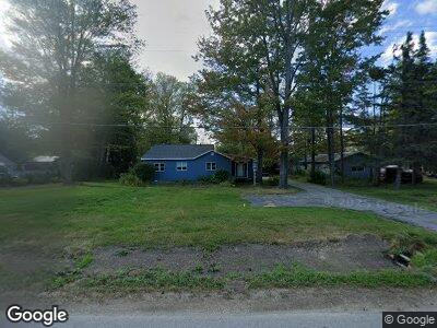
N1155 State Highway M35 Menominee, MI 49858
Estimated Value: $158,926 - $245,000
--
Bed
--
Bath
1,680
Sq Ft
$120/Sq Ft
Est. Value
About This Home
This home is located at N1155 State Highway M35, Menominee, MI 49858 and is currently estimated at $202,232, approximately $120 per square foot. N1155 State Highway M35 is a home located in Menominee County with nearby schools including Central Elementary School, Blesch Intermediate School, and Menominee Junior High School.
Ownership History
Date
Name
Owned For
Owner Type
Purchase Details
Closed on
Jun 11, 2019
Sold by
Federal National Mortgage
Bought by
Leclaire Casey A
Current Estimated Value
Purchase Details
Closed on
Jun 11, 2014
Sold by
Seid Kip
Bought by
Seid Kip
Purchase Details
Closed on
Oct 24, 2007
Sold by
Seid Kip and Seid Marlene
Bought by
Seid Kip
Purchase Details
Closed on
Oct 14, 2007
Sold by
Seid Kip and Seid Marlene
Bought by
Seid Kip
Purchase Details
Closed on
Jul 24, 1997
Sold by
Peterson Melody
Bought by
Seid Kip and Seid Marlene
Purchase Details
Closed on
Jul 1, 1997
Create a Home Valuation Report for This Property
The Home Valuation Report is an in-depth analysis detailing your home's value as well as a comparison with similar homes in the area
Home Values in the Area
Average Home Value in this Area
Purchase History
| Date | Buyer | Sale Price | Title Company |
|---|---|---|---|
| Leclaire Casey A | $31,235 | -- | |
| Seid Kip | -- | -- | |
| Seid Kip | -- | -- | |
| Seid Kip | -- | -- | |
| Seid Kip | $50,000 | -- | |
| -- | $45,500 | -- |
Source: Public Records
Tax History Compared to Growth
Tax History
| Year | Tax Paid | Tax Assessment Tax Assessment Total Assessment is a certain percentage of the fair market value that is determined by local assessors to be the total taxable value of land and additions on the property. | Land | Improvement |
|---|---|---|---|---|
| 2024 | $1,198 | $54,800 | $4,300 | $50,500 |
| 2023 | $356 | $57,300 | $57,300 | $0 |
| 2022 | $356 | $57,300 | $57,300 | $0 |
| 2021 | $356 | $55,300 | $55,300 | $0 |
| 2020 | $356 | $55,200 | $0 | $0 |
| 2019 | -- | $47,900 | $0 | $0 |
| 2018 | -- | $43,500 | $43,500 | $0 |
| 2017 | -- | $43,900 | $43,900 | $0 |
| 2016 | -- | $43,200 | $0 | $0 |
| 2015 | -- | $43,200 | $0 | $0 |
| 2014 | -- | $39,800 | $39,800 | $0 |
| 2013 | $356 | $46,200 | $0 | $0 |
Source: Public Records
Map
Nearby Homes
- n1055 Michigan 35
- N6804 E State Highway M35
- TBD E State Highway M35
- 0 E State Highway M35
- 519 47th Ave
- 4304 8th St
- 4103 Michigan Shores Dr
- 4017 N Shore Dr
- 901 39th Ave
- 0 Sn3 Dr Unit 50297266
- 3213 13th St
- 1704 32nd Ave
- 3012 16th St
- 1600 26th Ave
- 1612 22nd Ave
- 0 11th St
- 2300 19th St
- 1100 18th Ave
- 1616 7th St
- 1905 16th St
- N1155 State Highway M35
- N1159 State Highway M35
- N1167 State Highway M35
- N1173 State Highway M35
- N1168 State Highway M35
- N1152 State Highway M35
- N1180 State Highway M35
- N1180 State Highway M35
- N1194 State Highway M35
- N1204 State Highway M35
- N1156 State Highway M35
- N1160 State Highway M35
- N1149 State Highway M35
- N1143 State Highway M35
- 1128 10th St
- N1140 State Highway M35
- N1138 State Highway M35
- N1136 State Highway M35
- N1215 State Highway M35
- N1215 State Highway M35