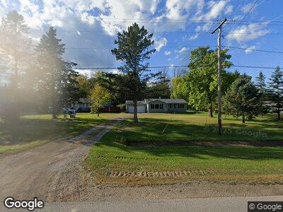
N1233 State Highway M35 Menominee, MI 49858
Estimated Value: $190,798 - $307,000
2
Beds
1
Bath
2,130
Sq Ft
$116/Sq Ft
Est. Value
About This Home
This home is located at N1233 State Highway M35, Menominee, MI 49858 and is currently estimated at $246,700, approximately $115 per square foot. N1233 State Highway M35 is a home located in Menominee County with nearby schools including Central Elementary School, Blesch Intermediate School, and Menominee Junior High School.
Ownership History
Date
Name
Owned For
Owner Type
Purchase Details
Closed on
Oct 31, 2017
Sold by
Schultz Steven M
Bought by
Kitzerow Patrick J
Current Estimated Value
Purchase Details
Closed on
Apr 15, 2015
Sold by
Richard Hintz and Richard Melinie
Bought by
Kitzerow Patrick J
Purchase Details
Closed on
Apr 8, 2010
Sold by
Hintz Richard and Hintz Melinie
Bought by
Hintz Richard and Hintz Melinie
Purchase Details
Closed on
Oct 1, 2008
Sold by
Buelteman William and Buelteman Donna
Bought by
Buelteman Donna
Purchase Details
Closed on
Sep 29, 2008
Sold by
Buelteman Donna
Bought by
Hintz Richard and Hintz Melinie
Create a Home Valuation Report for This Property
The Home Valuation Report is an in-depth analysis detailing your home's value as well as a comparison with similar homes in the area
Home Values in the Area
Average Home Value in this Area
Purchase History
| Date | Buyer | Sale Price | Title Company |
|---|---|---|---|
| Kitzerow Patrick J | $111,000 | -- | |
| Kitzerow Patrick J | $97,300 | -- | |
| Hintz Richard | -- | -- | |
| Buelteman Donna | -- | -- | |
| Hintz Richard | -- | -- |
Source: Public Records
Tax History Compared to Growth
Tax History
| Year | Tax Paid | Tax Assessment Tax Assessment Total Assessment is a certain percentage of the fair market value that is determined by local assessors to be the total taxable value of land and additions on the property. | Land | Improvement |
|---|---|---|---|---|
| 2024 | $2,114 | $60,400 | $3,100 | $57,300 |
| 2023 | $523 | $60,900 | $60,900 | $0 |
| 2022 | $523 | $60,900 | $60,900 | $0 |
| 2021 | $523 | $52,700 | $3,600 | $49,100 |
| 2020 | $523 | $57,600 | $0 | $0 |
| 2019 | -- | $49,400 | $0 | $0 |
| 2018 | -- | $46,200 | $46,200 | $0 |
| 2017 | -- | $46,800 | $46,800 | $0 |
| 2016 | -- | $51,500 | $0 | $0 |
| 2015 | -- | $51,500 | $0 | $0 |
| 2014 | -- | $50,000 | $50,000 | $0 |
| 2013 | $523 | $52,300 | $0 | $0 |
Source: Public Records
Map
Nearby Homes
- n1055 Michigan 35
- N6804 E State Highway M35
- TBD E State Highway M35
- 0 E State Highway M35
- 519 47th Ave
- 0 Sn3 Dr Unit 50297266
- 4103 Michigan Shores Dr
- 4017 N Shore Dr
- 901 39th Ave
- 3213 13th St
- 1704 32nd Ave
- 3012 16th St
- 1606 29th Ave
- 1600 26th Ave
- 0 11th St
- 2300 19th St
- 1100 18th Ave
- 1616 7th St
- 1905 16th St
- 714 14th Ave
- N1233 State Highway M35
- N1243 State Highway M35
- N1215 State Highway M35
- N1215 State Highway M35
- N1249 State Highway M35
- N1232 State Highway M35
- N1236 State Highway M35
- N1240 State Highway M35
- N1240 State Highway M35
- N1224 State Highway M35
- N1257 State Highway M35
- N1260 State Highway M35
- N1250 State Highway M35
- N1278 State Highway M35
- N1268 State Highway M35
- N1271 State Highway M35
- N1271 State Highway M35
- N1204 State Highway M35
- N1173 State Highway M35
- N1302 State Highway M35